UTAH FALL COLORS LOOP: Eyrie
Peak (8,136'), Lewis Peak (8,031'), Ben Lomond (9,712'), Chilly
Peak (8,600'), and Brianhead (11,307'), North Rim of the Grand
Canyon, and Zion National Park
September 28 to October 5, 2006
 Monet never had as fine or grand a landscape as
the Utah Rocky Mountains! A splendid palette of color worthy of
any artist's greatness also greeted me on my fall tour around
the Great Basin, this year. Having little else to do this early
fall, with reasonable room rates obtainable on the Internet, I
left home Thursday morning, the 28th of September.
Monet never had as fine or grand a landscape as
the Utah Rocky Mountains! A splendid palette of color worthy of
any artist's greatness also greeted me on my fall tour around
the Great Basin, this year. Having little else to do this early
fall, with reasonable room rates obtainable on the Internet, I
left home Thursday morning, the 28th of September.
Gas was down locally to 2.519. Zooming eastbound on Interstate
80, I made my first big photo
stop at the Ruby Mountains, up Lamoille Canyon. This time,
the aspen were in the middle of the fall transition, and the colors
were good. Being later in the afternoon, shadows had fallen over
most of the canyon slopes, diminishing the photography. I went
about shooting anyway, doing the best I could. Motoring to the
Road's End, I wondered about a peak hike, maybe to Liberty Peak,
the next day. Well, been there, done that, twice already. If I
could travel quickly enough the next morning, new peaks were waiting
in nearby Utah.
Lodging cheaply in Wendover, I woke up
early Friday, and sped across the Salt Flats. In North Salt Lake
City by about 8 a.m., I gassed up, with some easier peaks in mind.
Fuel was higher out here, most about 2.869, and up to 3.099, later,
for me.
Coming to Ogden,
UT, I stopped at the USFS visitor center to get maps and information.
Finding the way to North Ogden Divide (elevation 6,184'), this
trailhead would serve me for two consecutive peak hikes.
Starting up the marked
trail to the south, I switchbacked through glorious reds of
the maples, and tans of the oaks. I soon reached the higher slopes,
and shortly gained my first summit, Eyrie Peak. No sign marked
this highpoint, and my maps weren't very detailed. I hiked three
bumps in the vicinity to ascertain touching the top. Cairns or
rocks marked all bumps, and I was confident this peak had been
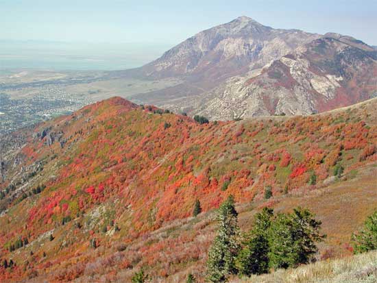
bagged. Signs directed me further to top Lewis Peak, a slightly
lower mountain to the west. Some ups and downs on trail led me
to this bonus peak, and I gained the fine vista of Ogden, below.
Ben Lomond (top photo) was seen to the north, my main peak goal
for this trip.
 I
retraced my route back, catching a bump that I missed on my ascent.
Most bumps had trails going around them, as well as to their tops.
Plenty of good color was seen on the ranges in all directions,
with the Great Salt Lake to the west.
I
retraced my route back, catching a bump that I missed on my ascent.
Most bumps had trails going around them, as well as to their tops.
Plenty of good color was seen on the ranges in all directions,
with the Great Salt Lake to the west.
Back to my car, I motored off to get my
reserved motel room at a fair rate, although I saw much lower
rates were to be gotten elsewhere, if I had known. Travel here,
this time of year, is very accomodating, with the sights of nature
to be affordably reached. I managed a quick walk of the historic
part of Ogden as magic hour
passed.
Saturday was my biggest hike day. I motored
up again to North Ogden Divide to start my second peak
hike by 7:45 a.m. The Skyline Trail leads to Ben Lomond, the
prominent peak as seen to the north, from Ogden. Nearby Willard
Peak is a bit higher, and also is the highpoint of Weber County,
but is a drive-up, with 4WD. I had hoped to bag three peaks, but
reality set in, as I am just too slow.
Motorbikes, some with bow hunters, puttered
up this trail. This area is not wilderness, but I thought of such
noisy and fuming machines as a possible savior in the event of
a freak accident. Luckily, as always, no such turn in my luck
was to plague me today. Mountain bikes also use this trail. My
hiking was fast. I gained the high ridge after about two hours,
and enjoyed the views of the civilized valley below. You'll have
to like the sight of sprawling towns to enjoy the Wasatch Mountains!
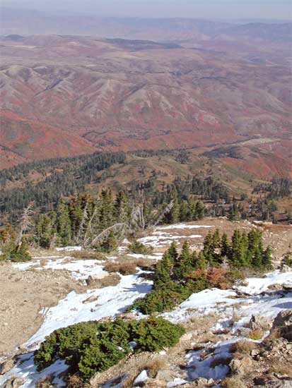
 Seeing
other hikers who had started ahead of me, I stopped to chat with
a few. I encountered some snow, and captured the beauty of this
early winter sight, here (second photo). Topping
out after some five hours of hiking, more hikers also stood
about the summit. They reported some mountain goats on the way
along to Willard Peak. I chose to rest, and forgo the extra hike
to the highest peak, and contented myself with Ben Lomond. This
was signed as a 8.2 mile hike, each way, with the 5.5 miles, each
way, yesterday.
Seeing
other hikers who had started ahead of me, I stopped to chat with
a few. I encountered some snow, and captured the beauty of this
early winter sight, here (second photo). Topping
out after some five hours of hiking, more hikers also stood
about the summit. They reported some mountain goats on the way
along to Willard Peak. I chose to rest, and forgo the extra hike
to the highest peak, and contented myself with Ben Lomond. This
was signed as a 8.2 mile hike, each way, with the 5.5 miles, each
way, yesterday.
There is a register, with a book 2/3's
filled with this year's entries. Hundreds of people sign in.
After water and a rest, I started back
down. Chilly Peak, a bump along the ridge, awaited me. Back
to the use trail that leads up this secondary bump, I contemplated
my chances. It looked to be short, but with some scrambling. I
decided to bag it, with it's funny name, and the short climb proved
to be a snap. No register, but with a lone rock as cairn, I snapped
photos of my trivial, 15-20 minute, off trail, venture. It has
an easy, gentle, slope to the south, so I took that back to the
trail.
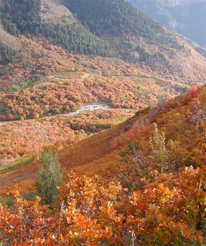
With the late afternoon, I slowed to photograph
the colors and light. This will do, for finishing my long-term,
state-wide tour of Utah fall color ops. The North Wasatch is different
from the rest of the range, and state.
Back to my car, I drove down the scenic
and also colorful highway, and came back to town and my motel.
Washing up, I sought to get a nice meal. I tried to lose weight
on this trip, as advised by my medical professionals, since I
may have some coming, serious, issues, now, from being so overweight.
Next
BACK TO PETE'S
THOUSAND PEAKS HOME PAGE