A SOUTHWESTERN
DESERT ROAD TRIP: Valencia Peak (1,347'), Sandstone Peak (3,111'),
Mt. Ajo (4,808'), Sugarloaf Mountain (7,310'), Wasson Peak (4,687'),
Picacho Peak (3,382'), and More
December 16,
1998 to January 3, 1999
I
planned to attend a joint, HPS/DPS, peak section, Angeles Chapter,
Sierra Club activity to Southern Arizona over the week of Christmas
1998 and New Year's, 1999. This was called the "Arizona Snowbirds"
activity. The extended weather forecast was very good the week before
this trip, scheduled to start on December 23, 1998. I had my personal
business taken care of, so off I went.
Driving first to Pinnacles
National Monument, I hiked a High Peaks Trail loop. This is
a five mile hike through some of the most spectacular portions
of the park. One winds along, using rock carved steps and handrails,
in some places, through a panoply of rock formations. This hike
I took from the Visitor Center, approached from the east side
of the park, via Highway 25. I had tried to climb Scout Peak,
the highest point along this trail, but it was apparently a difficult
rock climb.
Taking back
roads to King City, CA, on U.S. 101, I secured a motel
room. I like to camp. But with the long, colder nights this
time of year, the prospects of leisurely, nearby, restaurant meals,
with an inexpensive room coming with a bed, shower, and television,
proved too much to resist. The town was done in Christmas lights,
as many towns I visited, and I did some library reading to pass
the time.
 Moving
southward the next day, I drove on U.S. 101, then Highway 41,
to Morro Bay. Morro Rock loomed over the landscape as I drove
to it (photo, right). This is a pleasant, quiet, coastal town.
Taking plenty of pictures of
the seaside businesses, I enjoyed a short walk about the seafront.
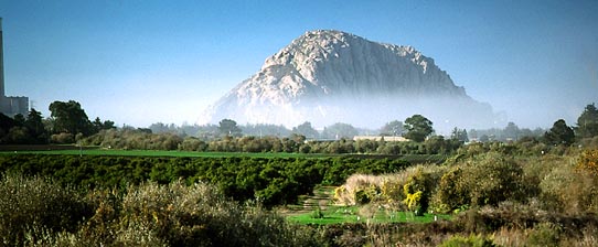
Moving
southward the next day, I drove on U.S. 101, then Highway 41,
to Morro Bay. Morro Rock loomed over the landscape as I drove
to it (photo, right). This is a pleasant, quiet, coastal town.
Taking plenty of pictures of
the seaside businesses, I enjoyed a short walk about the seafront.
Motoring on, I drove southward to Montana
Del Oro State Park. I hiked to the top of Valencia
Peak (1,347'). A good trail, winding through seaside ecology,
leads to the summit. I had read about this hike in a travel section
of a major paper. This was the first of many points on this trip
which I define as a peak ascent. This hike took me about two hours
round trip. Some schoolchildren were being led to the top by two
teachers, so it is an easy peak.
Driving on to Avila Beach, then Pismo Beach,
I took in more views and photos.
If I had the resources, these would be nice places to live. Passing
through Guadalupe, CA, I came
to Lompoc, CA, and took another motel room.
December 18th, Friday, I headed for Santa Barbara. At the visitor center
along the oceanfront, I discovered a map for a historical walk
about the downtown area. I hiked about the nice, Early California-motifed
buildings, and visited some shops.
Stopping in Ventura, CA, I snapped a few
more photos. Taking U.
S. 101, by lunch, I came to Thousand Oaks and chose there,
at the SMMNRA visitor center, to hike Sandstone
Peak (3,111'). This is the highest point in the Santa Monica
Mountains National Recreation Area. This is another easy hike,
but I had limited visibility and cold wind. I didn't get much
of a view, but through the clouds, I gained a few glimpses. My
time to the top was about one hour, again.
Discerning that there was a Sierra Club
night hike nearby about Tarzana, I had a good dinner, and drove
to the meeting place at Caballero Canyon. Several hikers appeared.
We were taken by the leaders, up into the hills, to the unpaved
Mulholland Road. I took a night photo of the city lights in the
distance. They don't use flashlights, saying the lights of the
San Fernando Valley below would be enough to see by. This took
about two hours, and was excellent exercise.
I decided to splurge, and got another motel
room in Van Nuys. Next door was a famous, Southern California
burger joint, which had a very good cheeseburger.
December 19th, Saturday, I just had time to spend before the all
night hike, "L.A. Christmas by Night," led by the Hundred
Peaks Section. After a cloudy view and photo
of Santa Monica Bay, I motored about, visiting Santa
Monica, Venice, the L.A. County
Museums, and even seeing an IMAX movie, "Everest."
I had cups of soda and coffee to prepare me for staying up all
night.
Meeting the HPS group in downtown Los Angeles
at midnight, we hiked over to the nearby, run-down area, and passed
out food and clothes to the homeless persons. I had bought considerable
amounts of groceries and had taken old ski clothes to hand out.
This charity hike has been run for several years. Almost a hundred
hikers started out tonight to do this.
After our gifts were given out, we were
taken by the leaders about the downtown business district. We
viewed wonderful Christmas lights and displays. One security guard
was very gracious to allow the group in a store to see these.
We also toured Little Tokyo,
Union Station and Chinatown.
After an early breakfast, we hiked back to our cars.
I drove east on I-10 to sleep at Harwood
Lodge. This is run by the Angeles Chapter, Sierra Club. I
was tired, and appreciated the inexpensive bunk. Spending three
nights here, I watched videos and just relaxed. Aside from the
overseers, I had the place to myself. My main activity was to
drive down once into Claremont to tour that town.
 On
December 23rd, I woke up early, and met the HPS/DPS group at one
of their meeting places in Pomona. There were six of us total.
We headed east, and down, to Yuma,
Arizona. We visited the Territorial
Prison, now an historic park. Moving on, we lodged in Gila Bend, AZ.
On
December 23rd, I woke up early, and met the HPS/DPS group at one
of their meeting places in Pomona. There were six of us total.
We headed east, and down, to Yuma,
Arizona. We visited the Territorial
Prison, now an historic park. Moving on, we lodged in Gila Bend, AZ.
The next day, we sought to visit more museums.
The one in Gila Bend was austere. The mining museum in the town
of Ajo, near the big copper mine,
was closed. Reaching Organ Pipe National Monument, we took the
53 mile, Puerto Blanco Loop road. This is a wonderful, self-guided,
auto tour with many stops for natural history interest.
Three of us rode in the leader's van, sparing our own cars from
the washboarded dirt road. A nice camp was made in the Monument
campground.
On Christmas Day, the plan was to climb
Mt. Ajo (4,808'), a DPS peak. It was
the most beautiful December 25th that I have ever had! Hiking
upward on trail, the views were spectacular! I took plenty of
photos, and we reached the top, with nice vistas,
after 3.5 hours. The descent made for photos
as well.
We had a holiday meal in the town of Ajo,
and then camped nearby at an RV park.
On the 26th, after a quick walk about Ajo, AZ, we toured the Tohono
O'odham Reservation, which is the home of the Papago Tribe.
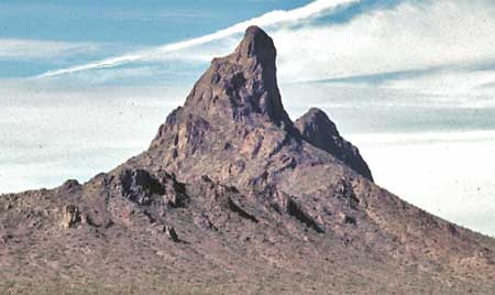
I left the group temporarily to visit Picture Rock, on the road
approach to Baboquivari Peak (second photo right). There are petroglyphs here. Motoring east
on AZ 86, I joined the group again at Mountain
Park near Tucson, AZ, where we camped for two nights.
Sunday, we went to the Arizona-Sonora
Desert Museum, where a large, open-area, wildlife zoo was
the main attraction. I am philosophically opposed to zoos, but
the animals here had extensive spaces to wander, and were not
penned up in small cages. They looked happy, and healthy. Spending
much of the day here, we also visited the nearby Saguaro National
Park's western unit. We hiked to another petroglyph
site. We spent the evening with a nice restaurant dinner in
Tucson.
Monday, the 28th, we hiked in the east
unit of Saguaro National Park. I left the group, again, to
hike in Sabino Canyon, a popular
recreation area on the outskirts of town. Phoning some local peak
climbing associates that I knew, we met for an evening walk, and
then a light dinner at a Southwestern restaurant.
Tuesday, I woke up early and drove to Nogales, AZ, to meet the group again.
We motored on AZ 82 to Patagonia,
AZ, which I had been curious about for a long time. Further
east on AZ 82, going into Sierra
Vista, we visited the Fort Huachuca military museum. Then, in
Bisbee, I chose finally to leave the
group. There were too many things to see and do, and I have a
"rush" attitude. I wanted to do more hiking, since the
weather was excellent, and there were peaks to climb. I passed
through Tombstone, AZ, to see what sights
there.
 After
another motel stay, in Willcox,
AZ, I drove, with a nice
sunrise, to Chiricahua National
Monument to climb Sugarloaf Mountain (7,310'). The vista
from the top was superbly desolate. I loved seeing the sights
on the popular trails. There are balanced rocks, and I shot many
of them, and other unusual formations. I hiked about a dozen miles
to see the best of these.
After
another motel stay, in Willcox,
AZ, I drove, with a nice
sunrise, to Chiricahua National
Monument to climb Sugarloaf Mountain (7,310'). The vista
from the top was superbly desolate. I loved seeing the sights
on the popular trails. There are balanced rocks, and I shot many
of them, and other unusual formations. I hiked about a dozen miles
to see the best of these.
There were nice sights
on the way back to the Interstate. I drove back to Tucson and
readied for a two peak climb the next day.
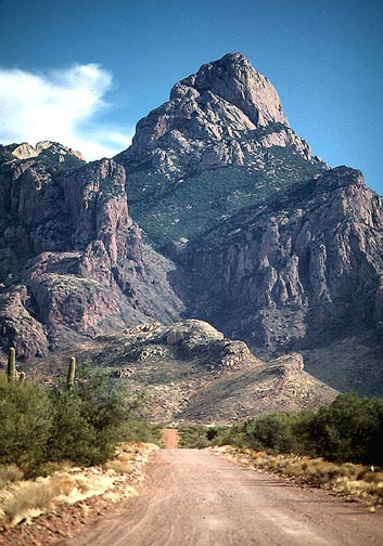
I woke up early, and started my trail hike/climb
of Wasson Peak (4,687'), the highest
point in the west segment of Saguaro National Park, as well as
a range highpoint. This took all morning. Then, I motored to Picacho
State Park to climb Picacho Peak (3,382', photo left). A trail
leads to the top, with handrails and cables to assist on steep
sections. This took me about three hours, total, round trip. The
views were O.K. It felt nice
to be climbing and cruising about the desert. I was really enjoying
it.
Celebrating the New Year in Phoenix
quietly, I drove north, on the first, to visit Montezuma's
Castle, Sedona, Oak
Creek Canyon, Flagstaff, see Humphreys
Peak, and the Grand Canyon. This
was great! I snapped many photos, but the light wasn't so dramatic.
Coming to Kingman, AZ, I wondered about heading home. I decided
to spend a couple more days out.
Spending the next morning walking and touring
in Las Vegas, I went to the Stratosphere
Tower for a few views. In the
afternoon, I motored north on U.S.
93 to see remote parts of Southern Nevada. The Extra-Terrestrial
Highway (NV 375) proved mildly scenic.
I'd love to explore the peaks around here. I wound up in Tonopah,
NV, that night.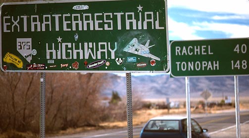
My last day, January the 3rd, 1999, was
spent driving north along U.S. 95, then to Reno. I came home to
cold, thick fog, by 1:42 p.m.
I had spent roughly $800, much on lodging.
I ate in restaurants almost every meal, and purchased postcards,
a travel book, and souvenirs. I had purchased a National Park
System Golden Eagle Pass, at $50, for the parks and monuments.
This came in very handy, also, for my 1999 Northwest Loop. My
total driving came to 3,571 miles. My hiking stats were about
70 miles with 13,000 feet gain. My fuel efficiency was about 50
miles to the gallon. If I can get a hiking partner, I know now
of several more peaks and hikes to do. For me, this is living!
BACK TO PETE'S
THOUSAND PEAKS HOME PAGE