FEATHER FALLS AND TABLE MOUNTAIN
April 22, 2001
My buddy Rex thought of repeating this beautiful hike and drive. We carpooled out to Oroville, CA, and took Highway 162 east, through town, then to a view of Lake Oroville. The reservoir was considerably down, due to the drought, I would presume. We searched for the paved side road to the developed trailhead, and had to backtrack a bit, not sure of ourselves. I had done this hike many times, but memory can be wrong.
Briefly, after going through town, take Forbestown Road to Lumpkin Road, then to the well signed turnoff in lovely foothill country. A large parking lot with a stone restroom and plenty of signs, with a mapboard, welcomes the hiker.
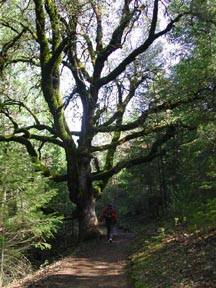
Starting at 9:50 a.m., we took a new loop fork trail, and crossed a new bridge over a beautiful cascade. One fork is 3.3 miles, and the one we took first was 4.5 miles, although more level.
I kept thinking we would be there soon,
but the mile markers showed it was yet a ways. After views of
Bald Rock Dome, we came to the final ridge and then to the handrailed
cliff trail to the massive observation deck. Some 20-25 hikers
were already there, standing about. I waited till they all left
before taking out my camera to shoot photos and movies of the
falls. This is the third highest fall in California.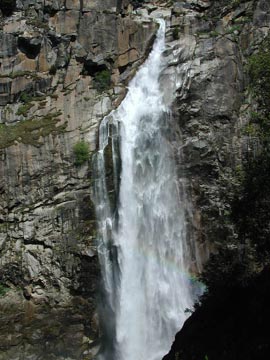
Plenty of water was gushing over the edge, for about an eight hundred foot drop. I have seen this many times, now, so only wished for another photo record. Several people have been swept over the falls, since playing carelessly on rocks at the top of the falls could result in a slip into the rushing water. Such force of water is tremendous, and not realized by inexperienced people till it is too late. Foolish games and feats of daring might result in tragedy.
We stayed for lunch, then headed back on the shorter but more "difficult" fork. There was a noticable absence of flowers this year. I remembered from my photos that the bloom was far better in another year. We saw mainly lupine and red maids, with a few wallflowers and paintbrush. It is all past the peak, apparently.
Back to the parking lot at 2:06 p.m., we
organized our gear quickly, and then headed back to Oroville to
the normally spectacular Table Mountain
flower show. 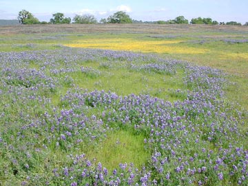 From
the freeway, take Grand Avenue east, to Table Mountain Boulevard,
and then right on Cherokee Road. A winding, narrow, backroad leads
in several miles to the top of the volcanic plateau, with the
rocky fields interspersed with the carpets of flowers. I knew
the poppies were normally far more profuse, but this year, none
were to be seen. Fields of blue lupine and some goldfields made
a mediocre display. Families played near a large parking lot,
with kites flown, and some walking about. This may be a place
known mainly only to locals, but for photography clubs. We left
quickly, and had burgers in Marysville before getting home.
From
the freeway, take Grand Avenue east, to Table Mountain Boulevard,
and then right on Cherokee Road. A winding, narrow, backroad leads
in several miles to the top of the volcanic plateau, with the
rocky fields interspersed with the carpets of flowers. I knew
the poppies were normally far more profuse, but this year, none
were to be seen. Fields of blue lupine and some goldfields made
a mediocre display. Families played near a large parking lot,
with kites flown, and some walking about. This may be a place
known mainly only to locals, but for photography clubs. We left
quickly, and had burgers in Marysville before getting home.
The falls loop hike is nine miles, with maybe 1,000' gain, round trip. While I have seen the falls running better, we have some serious water shortage problems this season.
BACK TO PETE'S THOUSAND PEAKS HOME PAGE