FISKE (2,868') 8X AFTERNOON CONDITIONER March 1, 2003
Waking
up late, as I often stay up into the wee hours of the morning
working on my computer and watching TV, I had some weak plans
to hike this Saturday. Checking the news and updating some software,
I made breakfast, then charged up a digital camera battery in
preparation of a hike today.
I left home, finally, at about noon. Motoring out on Interstate 5, I passed through Woodland, CA, and took Highway 16 northwest. I was of the mind to do this small peak as a speed climb. I know from my notes that it takes me less than 2 hours to ascend, if I'm moving.
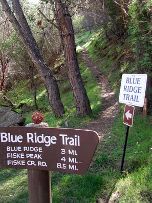
Arriving at Cache Creek Regional Park, the paved parking lot was still "closed for winter." I parked under a pine tree, and began my hike at 1:29 p.m. The road gate sign stated "bridge is out," but taking a quick look, it was fine for hiking.
Taking the signed trail, I pushed to make some good time. Usually I do this hike in the dead of winter or late fall. This day, however, the flowers were blooming. Plenty of paintbrush, shooting stars, Indian warriors, red maids, tiny white and blue flowers, some bigger yellow ones, and then even a few poppies graced the path upwards.
I have a problem with my digital camera
for focus. It tends to be sharp for the flower background, not
the flower itself. I can close focus to 1.6", but if it doesn't
register to focus on the subject, the photo is no good. The smaller
the flower, the worse the focus.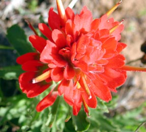 There must be some override settings, but I'll have to study my
manual.
There must be some override settings, but I'll have to study my
manual.
The trail was mostly damp, but never muddy. I hurried to have some good quality time on the summit. A point, on a ridge, to rest about halfway up, with a view of the Highway 16 bridge below, I reached in about an hour. Slaking from my single liter canteen of water, I saw it was going to be a cool day, so knew not to bring too much.
The trail goes up at a good angle, twisting and turning. I'd describe this as a "rough" trail for beginners. Rocks have to be stepped up on, and good footwork is needed not to slip or slide.
Doing some wishful thinking as I grew close to the main ridge, I pushed ever onward. Getting there by 3:06 p.m., I knew the summit of Fiske was only 20 minutes or so away. Surprised I didn't see anyone else on this trail this whole day, I topped out at 3:23 p.m.
My 1998 register jar and book were still there beside the elevation sign, "2868." Some water had condensed on the inside of the glass jar, so I opened it and let the damp pages of the register book dry out. I was of the mind to wipe out the dew on the inside of the jar, but I let it dry out in the wind and sun.
I started my usual round of picture-taking,
with fairly clear views. Much of the usually smoggy Central Valley
was laid out to the east. Sutter Buttes stood out as a dark, low
mass. The Sierra Nevada and Lassen Peak were visible. I couldn't
tell if it was clouds or Mt. Shasta, but there was something big
and white, faraway, in that direction. Other register entries
report seeing Shasta, and I did see it, once years ago. The hazy
view to the Capay Valley was nice and green, at least. I snapped
a record of the pages since my last visit, nice to do without
using expensive film. I did a self-portraiture, and enjoyed my
summit stay with a cold can of soda.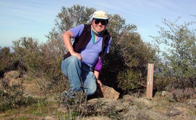
Wrapping it up and heading down at 4:00 p.m., I knew I was O.K. on time. I allowed 2 hours to hike each way, although my time down was some 97 minutes on this fine day. Passing another nice view, I needed a good shot for my newsletter cover, lest I didn't do another peak photo this month.
Figuring no one would be climbing up at this late hour, I assumed I will be the only hiker on this peak this day. I love the late afternoon light. Snapping more pictures as I could "see" them, I felt so safe and comfortable now, with warm sun lighting parts of the traversing trail. I almost ran down some parts, and soon could hear the highway traffic. Then, knowing this trail well, I anticipated the end of the hike.
To the end of the actual trail at 5:30 p.m., I walked along the dirt road over the low water bridge. I was at my car by 5:37 p.m. I had taken a picture of the deepening sunset light on the peak. I soon packed up and motored off, after noting a family finish with some fishing in the creek.
I rate this as 8 miles with some 2,400' gain, round trip. I shot some 80 digital photos. I saw only one tick. Some small trees and branches have fallen across the trail at points. The brush needs some clipping at the higher elevations, too. It's good to have some gain fairly close by to my home, and get a piece of the sunlight on this, again, fair day.
BACK TO PETE'S THOUSAND PEAKS HOME PAGE