EAGLE MOUNTAIN #2 (3,806'), BROWN
PEAK (4,947'), AND SMITH MOUNTAIN (5,913') February 17-19, 1996
 For another desert holiday weekend, we carpooled
to do this collection of peaks on the eastern side of Death Valley
National Park. Meeting in the town of Shoshone, CA, we drove north
on CA 127 to gain our view of Eagle Mountain #2. Again, the DPS
style is to give peaks with duplicate names a number. There is
another Eagle Mountain to the south, in Joshua Tree National Park.
For another desert holiday weekend, we carpooled
to do this collection of peaks on the eastern side of Death Valley
National Park. Meeting in the town of Shoshone, CA, we drove north
on CA 127 to gain our view of Eagle Mountain #2. Again, the DPS
style is to give peaks with duplicate names a number. There is
another Eagle Mountain to the south, in Joshua Tree National Park.
I had personally done Eagle #2 twice then,
now four times. It is a challenging peak, however only 1,800 feet
gain with a couple miles one way. But it is the only class 3 rated
peak in the Death Valley area. I am pleased to recollect that
I soloed the harder route in 1983. The standard DPS route goes
a different way, with a use trail and easier climbing.
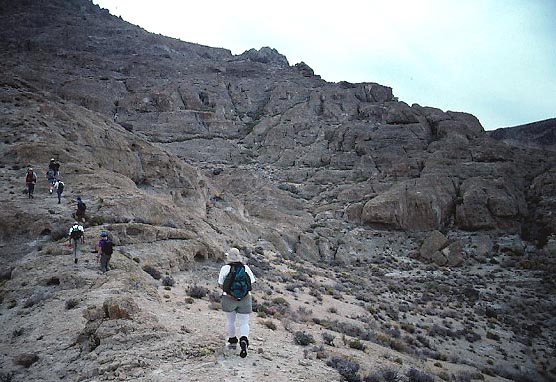
We took a broad
chute to the left (north) of the summit crags, which are visible
from the road. As you climb, some short traverses can be done
for easier climbing. Nearly to the top of the main ridge, an improbable
use trail is picked up and leads through otherwise difficult terrain
to the base of the summit crags. A short bit of vertical class
3, with good holds, is done to get to the summit. Having started
at 8:22 a.m., I topped out at 10:35 a.m.
The weather was sunny
and nice. My 3X was to me, somewhat strange, but reflects
my love for these mountains. Few people would ever reclimb a peak
like this.
We ambled back down the same
route, and a look back at the peak reveals the broad chute
and the rocky route, looking so difficult or impossible to the
untrained eye.
A low wash on the opposite side of the
paved highway provided us with a car
campsite. Some of the group went north to Death Valley Junction
to enjoy the opera by Marta Beckett, which is a must see for some.
I guarded camp, and read maps or books.
The next day, several trucks motored onward
up the Deadmans Pass Road to park off the sandy road and begin
our hike up Brown Peak.
We crossed a big stretch of desert pavement, which consisted of
a uniformly flat area almost as if it were deliberately cobbled
with small rocks. We ascended up sandstone cliffs (photo, top)
with wind formations, in a seemingly roundabout way to the top.
Sometimes, it appears as if the leader doesn't know what he's
doing. Have faith in the DPS, however!
My time was two hours and forty-five minutes.
The light was overcast, so didn't lend for any great photos.
The summit area is big and flat, and the participants formed a
line for a photo that appeared in the DPS newsletter. Taking a
slightly different way back,
it was a weekend wrap for several who came back to their cars.
 Five
of us stayed over another night
to get Smith Mountain, the second attempt for Rich and me. The
poor roads, with inadequate directions from the Guide, led us
to a start point nonetheless. This peak is really
easy if you can drive there.
Five
of us stayed over another night
to get Smith Mountain, the second attempt for Rich and me. The
poor roads, with inadequate directions from the Guide, led us
to a start point nonetheless. This peak is really
easy if you can drive there.
We followed the guide climbing directions,
and these were good. Going up a wash, we climbed onto a ridge,
then along it to a high bump. We continued along this ridge to
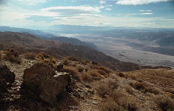
a lower bump to the west, and there was the summit register. I
was taken by the view, especially
to the south. We were some 6,000 feet above the Death Valley floor.
The clouds and light were really, "desert."
Getting
back to the trucks in 65 minutes,
we motored out together and began another long drive home. Although,
we stopped at a museum
for a photo or two.
BACK TO PETE'S
THOUSAND PEAKS HOME PAGE