 My attempts to find a partner to hike and climb failed once again. Having to get some exercise, I decided to do a local hike. I haven't been to this state park for 28 years.
 UNDER CONSTRUCTION
My attempts to find a partner to hike and climb failed once again. Having to get some exercise, I decided to do a local hike. I haven't been to this state park for 28 years.
So this Sunday, getting up early, I took Interstate 80 eastbound. Not getting enough sleep lately, it was a bit of an agony to have to drive. I went to Old Town Auburn to park and walk about, taking pictures in the early morning light. Having a hearty breakfast, I chatted with a friendly waitress. Making sure to leave a good tip, I headed northbound on CA 49.
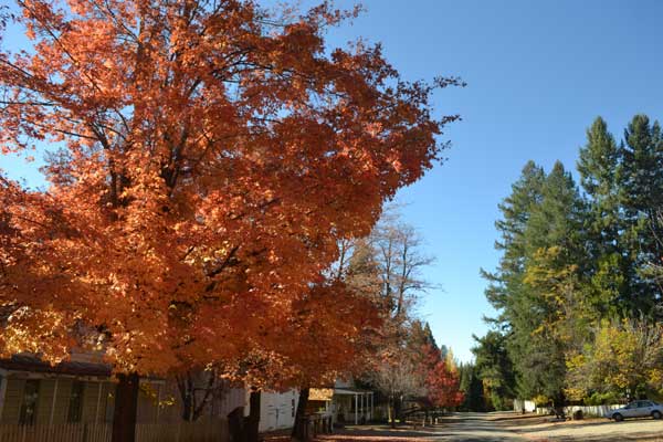
Passing through Grass Valley, then Nevada City, CA, I then was coming to the South Yuba River State Park. Using the restroom, I strolled out onto the old bridge to take video and photos. Then it was about 9 miles north to the signed turnoff for the state park. Taking the narrow, paved road eastward, I shortly came to junctions that were signed to lead me to the park. Coming then to North Bloomfield, CA, I parked my car and started with pictures of some fall colors. I saw no one else there, but then the ranger came out to chat with me.
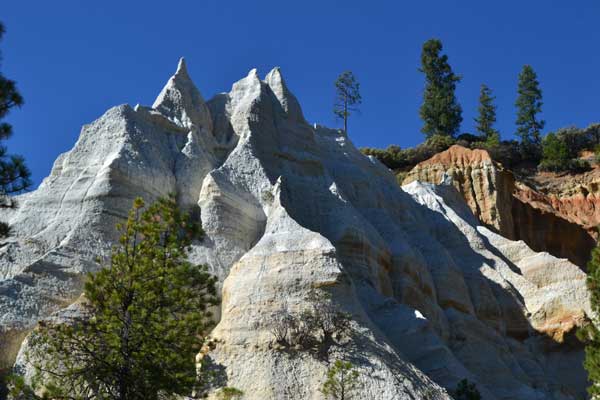
Finally getting to pay the $8 day use fee, I got my pack and started my hike. Heading south on the paved road past the historic buildings, I headed for the Diggins Trail. This would have the best sight of the eroded cliffs that were caused by the hydraulic mining in the 1880’s. Walking about a mile to the trail start, I did video of the falling leaves and pine needles.
Taking the south trail first, I soon was enjoying a nice, scenic hike, with the trail all to myself. Starting with photos of the rocky trail, meandering up-and-down for a bit, I took more pictures of the scenic cliffs. Doing a short side trip to see the Hiller Tunnel, I wondered if we had hiked through it in years long ago. There was a pond, and a boardwalk, and then I came to another trail junction.
The trail heading on the north side makes a loop back to the start. It runs directly under the eroded cliffs. I took lots of pictures, and the way was marked by posts with a yellow tip. The trail ran on and on, and a sign remarked that it was similar to Bryce Canyon in Utah. Finally, I had to cross a shallow creek, which was not to drink from, since this area is probably heavily polluted with mercury. The trail started to loop back to where I could see that I had started, as I kept my bearings.
 Completing the loop, I headed back for my car, but then I came to a sign indicating, “town site and cemetery.” Game to explore, I took this side trail to an intersection with a dirt road. With no sign there, I turned left. Believing by my bearings that I was headed in about the right direction, I started to climb up a hill. It then began to seem that I was hiking too far, but I continued.
Finally coming to a deserted campground, I checked my tablet. Turning on the cellular, I got one bar, but my maps refused to load. I waited for a few minutes, but there was nothing to tell me where I was exactly. I decided to follow the paved road, knowing it would lead me somewhere. It came to a main paved road where I saw cars going by. Believing that I had to head north still, I turned left on this road and hiked up the hill. After a while, I passed a sign which seemed to indicate that I was headed in the wrong direction. I continued to a sign marking the park entrance, so then I turned around and headed back. Of course now, I knew where I was.
A car stopped as I stepped off the road to let it pass, and they wondered if I was in trouble. I replied no, and walked about a mile back southward to North Bloomfield where my car was parked. Still good on time for things that I wanted to do, I came back, and the ranger came out to chat a bit more.
Going to use the restroom, the fall colors had largely disappeared by fallen leaves of the bright reds. I now motored back south on the paved road to the cemetery where I wandered about to look for a particular grave marker. One long ago deceased had the same name as a hike leader in the old hiking club. There may have been some vandalism as I recall the grave marker was historic, and now it was a simple one.
Good on time, I motored back to Highway 49 and headed south to Nevada City. Putting in a quarter at the public parking lot, I spoke with some fellow coming out of a restaurant. He advised me about Sugarloaf, which was a hill with a view of the town. Giving me the site at Coyote Street and North Bloomfield Road, I looked at my tablet to get the directions. It wasn't too far away, so I motored over there in a flash.
 I found the intersection, and looked for good parking. There was one space by a historic marker that wasn't blocking private driveways. Taking pictures, I found the road that leads to the top. Getting my pack out of my car, I went around a gate, and came to a sign marking the area as friendly to hikers. Excellent! I took more pictures as I hiked up this road which circled around the peak. The town wasn't much to be viewed from up here, but the sun was setting and I had a nice feeling. Coming to the top after about 10 to 15 minutes, I started with more pictures and enjoyed this little bump. It was pretty windy, but I did some video and a clump of cut branches seemed to be the highest point. I thought that I'd count this as a peak, since it is a worthy, short hike, that people should know about.
I shortly started hiking back down, and then came back to my car which had not been ticketed or towed. Two other hikers had parked at a shoulder further down Coyote Street, which seemed to be a better spot. I motored off, and went back to historic Nevada City. Paying another quarter to park again in the public lot, I went about Broad Street, taking pictures of the beautiful window fronts, during magic hour. Fall and Halloween motifs. Some of the most artistic displays that I have ever seen.
Making sure to give a big tip to the restaurant worker that informed me about the peak bump, I got a table at that highly rated eatery. Relaxing with a non-alcoholic beer and a gourmet salad, this was certainly nice. I told the waitress that I wanted $10 to go to the guy who had given me the hiking information. Finally finished with my meal, I wandered about the streets doing more photos of the window displays. It was getting to be late, but I knew the drive back home wasn't very long.
Taking 49 south, I was shortly to Interstate 80, and then stopped for a quick drink break and rest. I was pretty tired and sleepy, but thankfully made it safely back home.
Hiking then maybe 9 miles with 1,300 feet of gain, I had driven 188 miles. Spending about $72 in cash, I had captured 676 images and movie clips (644.6 MB, 720p HD, 14:46). I had used about a half tank of gas, maybe 5 gallons.
With some cool new software, I don't have to type up my notes, instead able now to use some incredibly fast dictation. I had given my contact information to the ranger as he said that he was interested in possibly teaming up. In a few days, I should have received a PLB, which I got online for a low price. Some new snow is due, but I will have a good time hiking this fall, wherever that may be. Still needing to have to shed some 20 pounds, I hope to get that done. Hopefully too, I'll have the best cellular phone to make my travels even better and more convenient. Tech wise, things are really looking up!
BACK TO PETE'S THOUSAND PEAKS HOME PAGE