UNDER CONSTRUCTION
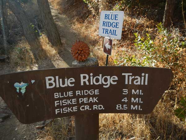
FISKE (2,868') 15X December 1, 2013
 Still wishing more exercise, I was feeling O.K. when I awoke this Sunday morning. Notifying my contacts of my plan, I headed out by about 8:20 a.m. to Interstate 5 northbound. Being a holiday weekend, there might be other hikers on the trail to the top of Blue Ridge. It may be a bit safer with some friendly company.
Passing through Woodland, CA, I took CA 16 north. I started running video of the drive, with fall colors in the oaks, to pass my time. Coming to the casino, I entered, and took a few photos of the decorations. Walking to the cafe for breakfast, I ordered steak and eggs. No fooling around with a forced diet when I may need the energy on this peak. The casino has upgraded since the last time that I was here, and with more time, I might have played some cards.
Doing more video as I passed from Brooks, CA, through Guinda, then Rumsey, I entered the Cache Creek Canyon. This is a nice display of color when the time is right, but it looked pretty dry. Several cars were parked at the Lower Site of the Cache Creek Canyon Regional Park, and I used the restroom. Putting my car outside the gate, there was no fee receptacle secured, anyway.
Starting then at about 10:50 a.m., I crossed over the low water bridge. The road now has a concrete barrier to block all cars. With two bottles of juice, and one liter of water, I sped up the trail, feeling great. In my old hiking days, I summited in 1:40, as I timed it. I’d be happy now just to do this safely. Not taking time to shoot many photos or much video, I shortly came to the halfway point overlook, and used my pee bottle. No pollution! Resting a bit, I wasn’t able to get any signal. Two hikers passed by, and then I started up again.
Figuring that luck had been with me, as when I led a hiking club group up this trail, decades ago, there was no incident, I sought to achieve the same safety, today. There were clippings on the pathway, and you have to watch your footing so carefully. I did well, keeping my balance, and knew that once I reached the high ridge, the trail was better. There were still the short, steep, sections, with rocks to step up or down, but my boots held well, and I never slipped.
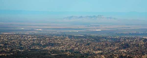
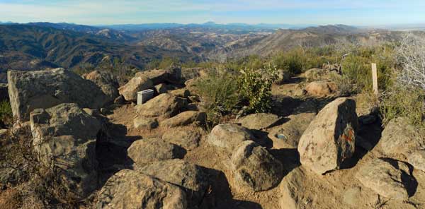 On the high ridge, I took it as some twenty minutes to the top. I sped along again, then topped out after some 2:31. Two other hikers rested to the side, and I went to the toprocks, doing then some drink, then camera work. With no flashlight, I determined to start back at 2 p.m. I did video and looked at the nice register book. Perhaps the dim mass in the distance was Mt. Shasta, and the Sutter Buttes made for a nice vista. One of my cameras had not had the batteries charged up, so I didn’t shoot good telephotos.
Time then to go down, I felt well, and thought of other hikers. Many would not like any of this. I warned of this trail as a “leg-breaker,” and a trip or slip might cause a bad tumble. Terrible rescue scenario, with it looking like an aerial operation needed to extract anybody. I enjoyed the hiking on down, with moves to connect the steps, then did well on time coming back to the rest overlook. Using my bottle once again, I rested and savored the moment. Maybe an hour back.
Doing video selfies as I hiked down some narrow sections, facing the low sun, I felt that I might be improving. If I can only shuck some major weight! I had a few days to stick about town, then maybe another short trip for more peaks. The stream beds were so dry, and the leaves were the same way. Coming to the end of the trail, I ran some video, then hiked back over the low water bridge, and arrived to my car in about two hours from the top.
 Quickly motoring off, I didn’t have much juice left in my camera batteries for more running video. The sun was now setting, and I stopped quickly at the casino mini-mart for drink and to use the restroom. Straight home, I looked in my mirror to see a fair sunset, no stopping, though.
Doing then 8 miles with 2,400 feet of gain, I drove 122 miles. Spending about $23, I captured 176 images and movie clips. Probably used 3 gallons of gas.
It might be really nice if they had bus service to stop at the trailheads, as I saw many buses going to the casino. Though with the lack of interest and support for hiking fitness, it would be a waste. Most people will drive their cars, and whomever without transportation probably wouldn’t be too interested in hiking.
With the hiking club, I started going with them to secure rides to the trails in the Sierra, then found out about other carpooling ops. They claim to base the ride-sharing on reciprocity, with drivers switching off. I believe in fuel efficiency and stopping pollution and waste, so wound up driving most of the time, once I started to be refused rides. There were some to give rides, but most of them didn’t do the thousand mile drives to go to parks or peaks, for hiking and all. I initiated the long range trips after failures on the leadership to attain simple peak goals.
There were a few to truly go far for exploration with me, but most do not care for travel, and like to do short days and not to stray too far away from home. While I camped, doing a lot of sleeping in my car, or by it, that got old quickly for most, and to help along the travel economy, started mostly on my own with economy motels. Progressing then to five diamond lodging, so went my dining. From camp food, to fast food, and now luxury gourmet, I’d wish that my hiking would have gone similarly. The peaks have been getting lesser and lower. But now, maybe things will all change for the better!
BACK TO PETE'S
THOUSAND PEAKS HOME PAGE