 Being a week since I had last driven my car, I figured to do something on this fine Saturday. I had breakfast, up early, and got to various items. Making up my mind to travel far, I made reservations and set out in mid-afternoon.
Being a week since I had last driven my car, I figured to do something on this fine Saturday. I had breakfast, up early, and got to various items. Making up my mind to travel far, I made reservations and set out in mid-afternoon.
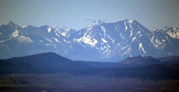
Taking Interstate 80 eastbound, I stopped in Nyack for a snack, then zoomed along the freeway. My usual stop at the enviro clothing store netted me some more bargains, and then it was to the interchange to U.S. 395 south. I wished to again complete driving all of the Nevada federal highways, as a new section, I-580, had been opened recently. I figured how to set my camera to do video as I drove along, safely enough, and went over Northern Nevada’s highest bridge. Back to the old freeway, I soon came to Carson City, NV, and drove to my motel.
I lounged in my room, figuring what to do. I soon got it in my head to try Mt. Whitney, as the trail is now open. I’d need to get acclimated and in some kind of shape. First, then, I’d see how I did on Mt. Dana, an easier, 13,000 foot peak by Tioga Pass in Yosemite National Park. Initially, I figured to bag Sonora Peak and Tioga Peak, but Dana sounded like a better bag. If I did this, would I be ready for a great summer of peaks in the High Sierra, as in years past! I had a Cobb salad, and retired giddy, with thoughts of a big comeback.
Up early, I had some drink, then motored off south on U.S. 395. I captured the dawn sights motoring along, with new things to see. Seeing later that the Eastern Sierra is roaring into the future, and retaining its cherished connection with the past, I had a small breakfast in Minden, then, enjoying the familiar sights, made another stop in Bridgeport, CA. I took photos of my old favorite haunts, then went into the historic restaurant for a fruit plate and more coffee.
It was Sunday, so the USFS ranger station was closed. There were views at the photo stop before Conway Summit. I stopped at the Mono Lake vistapoint for more photos of the peaks, then went to the Mono Lake USFS visitor center. I took many photos of the exhibits. The well staffed information desk helped on my peak plans, with some research on their computer. Yes, the quotas for the Mt. Whitney Trail were near empty, so if I did that, the permit would be no problem. So, it depended on how well I did on Mt. Dana. I went by the Mono Lake Committee store and picked up a free calendar and a gold ornament. With a coming, possible, 40% discount sale back in Reno, this would be a productive shopping trip!
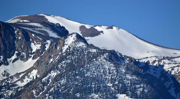
 Motoring up CA 120 to Tioga Pass, I parked at the gravel area just east of the park entrance station, and readied for my climb. I spoke with the rangers and they confirmed what I had been told, that an entrance fee was not necessary for hiking to the top of Mt. Dana. I took the use trail, and soon ran into snow. I knew the way, so navigated along the hike, keeping mostly to the trail or over the snow, mindful of not creating any new use trails. I took many photos as I hiked up, with extremely slippery mud in spots, water on the trail, and then ice, up higher. I shortly was out of the trees, and onto the steep, rubbly, use trail up. There were snowfields to connect up, and then I was kicking steps, even doing some chopping with my ice ax.
I had allowed some 4 hours for my ascent, being that the last time, on my 8X, it took me 3. This would get me to the summit by about 3:30 p.m. The days are long, and I can descend quickly on snow.
After about a thousand feet of gain, I began to feel the altitude. I haven’t been up high for quite the time, and started to feel that I might be overdoing it. I hiked Ralston Peak last summer, with about as much gain, but looking back at my winter, saw that I had been pretty inactive on summits. A Whitney summit now looked improbable. I might reach Trail Crest, but that is not the top, and it’d be the same old thing.
Taking a rest, and drinking water, two other hikers came down, one reporting 19 summits on this peak. They were well clad, and I had my jeans, no gaitors or crampons, trail runners for boots, and my typical heavy pack. I continued on up, doing some snow work, and then achieved roughly 12,000 feet elevation by about 2 p.m. With some rock structures, I took a rest. I figured to call it, and just enjoy the perfect weather. It was starting to get cold and windy, and I didn’t wish to dig into my pack for my parka. I relaxed, then thought to do some self video. Two skiers then came on down, and I spoke with them for awhile. Some more hikers seemed to be descending, and I took off down to get back to my car.
The skiers had left the snow and seemed to be hiking off to the ridge. I did my standing glissades, with plunge stepping, then came back to the bare trail. I warily hiked down, mindful of the slippery mud. I declined to snap more photos, much, and wondered why those people declined to take the trail down. In past times, we had skied the entire route, with snow to summit from the car. Not so this season, with a drier winter and spring. I stepped carefully down the trail and navigated on the snow in the trees.
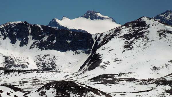
Back to the highway, I chatted with the ranger, and gave a brief trail report. They let me use the restroom, and I got back to my car. I did more video as I drove down the highway, winding up at the lower Mono Lake vistapoint. Going to the deli, I had two fish tacos. I needed energy. It was a good, old feeling, cruising on my favorite highway. I stopped at the viewpoint of the peaks with the snow chutes. I came to Mammoth Lakes, CA, and got my motel room. So, no Mt. Whitney for now. I rested and recharged my batteries, then went for salad and soup. After a few night photos, with a slight headache now, I’d head home.
 Monday, I got up early and went for coffee. Looking for breakfast, I had a fruit pastry, then motored off north. Taking more photos ahead on U.S. 395, Mono Lake vistapoint made another photo op again, then I stopped at the ranger station by Bridgeport. The view of the Sawtooth always makes for good telephotos. They didn’t advise to take the dirt road to Lobdell Lake with my passenger car, although in the deep past, I had made it easily with my Datsun wagon. So, no climb of Mt. Patterson, the highest peak of the Sweetwater Range.
I stopped at Topaz Lake Lodge for some more food, then passed through Minden/Gardnerville, taking Highway 88 westbound. With a quick photo stop for the vista of Red Lake, then stopping at Carson Pass, I checked for a peak hike to do, but Sno-Park is still in operation. I made some more photo stops, then took the now open Mormon-Emigrant Road to let my camera run as I sped along. After checking the new trailhead by Jenkinson Lake, Placerville, CA, made for more food and drink, then I detoured to Kalithea Park for a fast photo op. Shortly home, I got to my computer business, and savored a short trip, albeit with no peaks.
Hiking some 4 miles with 2,000 feet of gain, I drove about 600 miles. Capturing 966 images and movie clips, I spent about $175 cash and charged some $102 for lodging. Getting gas enroute at 3.499/gal., I used about 15 gallons.
Well, with a fair start to the peak climbing season, I am ready to restart my hobby, and it will depend somewhat if anyone will come forward to join me, or if it’s the usual solo travel, and then the lessened safety op, still with no cell phone or PLB.
BACK TO PETE'S THOUSAND PEAKS HOME PAGE