WINTER 2012 SOUTHWEST LOOP February 18-March 1, 2012
With the price of gas shortly to go up, and a nice forecast at my destinations, I figured that it was time for another adventure. I made my reservations online, and packed up my gear.
February 18 Saturday
 Leaving home in the mid-afternoon after a walk about town, I took Interstate 80 eastbound after deciding to leave a bit ahead of time. Some snow was due, so I had to beat the weather going over Donner Summit. I never had or needed chains, knowing the highway conditions, and what to expect. I made my first photo stop at Yuba Gap. Next came the rest stop at Donner Summit. I had some sights of the Mt. Rose massif along the way, then passed through Reno with a stop to get an organic cotton T at a low holiday sale price.
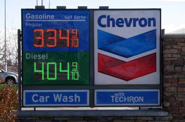
I enjoyed a nice sunset from a vista point along the Truckee River, then zoomed east with a food stop in Lovelock, NV, then with light snow passing by the Humboldt Range. I made it to Winnemucca, NV, and was greeted by the motel desk help, assuring me that I was now deep into Nevada. I had filled up in town with regular at 3.839, but out here, gas was as low as 2.999. I had my Wi-Fi connection, and liked being back on the road.
February 19 Sunday
Up at an early hour, I took off east on the Interstate, and had most of the road to myself. Sights of snowy Nevada ranges and dry powder on the road kept me occupied. Making a photo stop at Halleck, then with more photos on the road, I again stopped at Pilot Peak. With even more photos, I then came to Wendover. A stop at the rest area on the Salt Flats provided a photo op, then it was more sights ahead on the Interstate. Into Utah, I had snowy ranges ahead, like the Oquirrh, and then the Wasatch. Parking at the visitor center, I walked over to the Utah State Capitol, which has been beautifully renovated, took many photos, then motored to the nearby trailhead for Ensign Peak. I kept my boots from getting muddy by keeping to the paved trail to the lower overlook, rather than bag the peak 2X. This made for nice photos and video, once again.
Then, it was to Interstate 15 south. A ways south, I could legally go 80 miles per hour, and there was a nice cloudy sunset. Driving on U.S. 50 east in the dusk light, I came to Richfield, UT, where I had a salad and some bargain lodging. The low this night was 9 degrees.
February 20 Monday
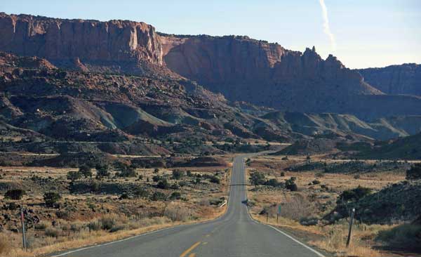 After breakfast, I took Utah Highway 119 east, to UT 24 east. There was powder snow on the roadway, but traction was fine. I crossed over some snowy passes, with a view from one, then continued south, then east to Capitol Reef National Park. Taking the Chimney Rock Trail, I hiked up to a slight pass, then turned back after a view. Then, I took a short dirt road to the Goosenecks overlook. There was another short trail to a Sunset Point, and back. I stopped at Panorama Point on my way back to the highway, then made photo stops at Fluted Wall and The Castle. I saw the visitor center was closed.
I paid a $5 fee (credited later) at the start for the Scenic Drive, and snapped plenty of photos as I motored south. I had done this once before in 2000, but with Kodachrome film. I reached the end of the paved road at Capitol Gorge, and declined to go further. It is beautiful, but I have seen it already, and had other new things to do. I drove back north.
Back to UT 24, I made a quick stop at the petroglyphs, then headed east. I took some photos of Factory Butte, then passed through Hanksville, UT. North on UT 24, I took the side road to Goblin Valley State Park. I paid the fee, then came to the overlook. I hiked into the rocks, and took plenty more photos. Making a loop about an indistinct trail, I climbed a hill for more vistas. Hiking back to the parking lot, I shortly motored off, with a few more photos of more sights.
Back to the main highway, I had some sights of the San Rafael Swell to the west. Coming to Interstate 70, I headed east to Green River, UT. I secured quiet lodging, then some fine dining.
February 21 Tuesday
 Up at about 4 a.m., I had breakfast, then drove east on I-70 to U.S. 191, which I took south. Bound for Canyonlands National Park, I hit a patch of ice on UT 313 at a 20 mph curve. Skidding, I regained control, and past the ice, zoomed on, in the freezing cold night. The roads were fine from here.
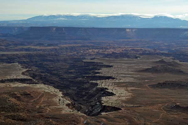
Seeking to catch the sunrise at Grandview Point, I arrived just in time, and started with hundreds of photos. I had the sight and spot to myself, with the snowbound La Sals in the distance. I did panoramas and telephotos. Finished, I stopped at Buck Canyon Overlook, then took a short hike to Mesa Arch. There, I shot many more panoramas and telephotos, and took the icy trail back. I made a quick stop at the Shafer Trail view, then went to the visitor center to get my 2012 park pass, and chat with the ranger.
Motoring on, I took the side road to Dead Horse Point State Park. I made a stop at the visitor center, and took the short walk there. I didn’t have time, so just went to the main point, and started with panoramas and telephotos. The sun had emerged from behind clouds, so I was lucky with the light. A nearby hill offered a slight op.
With time, I headed back to Grandview Point, and took more photos. Going to the Green River Overlook, then after another Shafer Trail view, I then did a short walk past a pinnacle on a plateau. Able to catch some videos of some bighorn sheep grazing along the roadside by the visitor center, I headed out of the park.
With more stops along the highway, there was an area with potholes, then a view of Monitor and Merrimac, two large rock formations. Making another stop at a view of U.S. 191, then entering Arches National Park, I took a quick stop at the Moab Fault view. I captured the sunset at La Sal Mountains overlook in Arches National Park, with some faint glow on some red rocks, with a telephoto lens.
To my quite bargain lodging in Moab, UT, I was to stay here for three nights. I had some fine dining, with a night overlook of the town.
February 22 Wednesday
 With a grey sky in the morning, I motored south on U.S. 191. My goal today was the Needles District of Canyonlands. Taking UT 211 west, I made a quick stop at Newspaper Rock, then leisurely motored along the road to the park. I had many sights of the Sixshooter Peaks. Coming to the park entrance, I took a few photos of the needles, then stopped at the visitor center. I’d spend the whole day here. Next was a stop at Wooden Shoe Arch view. First for hiking was a hike about the Pothole Point trail, which is a scenic vista and petroglyphs. Some birds made for videos. With a quick stop at a pullout, I drove to the end of the road which was scenic. Then, it was to the Slick Rock Trail. I did this hike with multiple viewpoints, 1,2,3,4, and 5, then took the half hour hike back to the car. Nice to get some exercise.
The ranger recommended the Cave Springs trail. I passed the cowboy camp, and then came to the spring. There are two ladders, then I got more views. Telephoto panoramas of the distant Needles. Back to the visitor center at closing time, I left with a few more photos of the drive out.
Back to U.S. 191, it was about 40 miles back north to Moab. I got some nice shots of the La Sals, then Wilson Arch. The sunset was quite spectacular. Dining well again, I retired to my motel.
February 23 Thursday
After a southwest breakfast, I went to the Arches National Park visitor center where the ranger apprised me of what I could do, that was new to me. I made some reservations for the Fiery Furnace tour ($10), then left for a new hike to Tower Arch. Taking a washboarded 7.2 mile dirt road to the trailhead, I made use of the facility there. I had to hurry. With the reserved hike at 1 p.m., I didn’t want to miss it. I hiked on the trail over a small ridge, and gained sights of the Watchmen. Following ducks, I navigated through rocks, and then came to a 4WD road in 50 minutes. I had to look at my map. I missed the arch. Turning back, I then saw Tower Arch. I then took a side trail to the base of it, and declined to go through it. I hurried back to my car, and then motored more slowly back to the paved park road.
I had time, so drove to the Devils Garden trailhead to wash up. Getting to the Fiery Furnace trailhead in good time, I was greeted by the ranger who was to conduct the hike. He explained what to expect on the three hour tour, with no facilities and some strenuous scrambling. Starting off, I began with my photos. Not wishing to get the people in my pictures, most of my shots are looking back the way we had been led. There are narrow slots with some chimneying to negotiate some sections, and small arches. Two hikers without packs dropped their water bottles, and other hikers had to retrieve them. There were more slots and ledges, then we came to an arch. This was the final good one, and the ranger gave a good lecture. Updated, you get to know this national park. We had more steps and slots to get back, and then the tour finished. Quite worth the time!
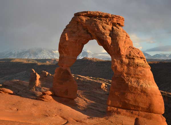 I drove to the Delicate Arch trailhead for another crack at the sunset photography, my 3X. With a side trip to the petroglyphs, I completed the half hour hike, for me, and arrived to the view at the optimal time. Many photographers were there, with some professional looking people. The light soon dimmed as the sun descended behind low clouds, and the fiery red alpenglow was not to be. I hiked back with red clouds in the sky, and never needed a flashlight. Driving out of the park, I did some more fine dining in Moab, then enjoyed my free motel Wi-Fi connection.
February 24 Friday
I had a long driving day ahead. Taking U.S. 191 south again, I passed through Monticello, UT, with a sunrise, then south to Bluff, UT. I had sights ahead, then came to Arizona. I was on Navajo and Hopi land. It is still desolate country, with some beauty, and then I came to Chinle, AZ. Canyon de Chelly National Monument is a short way east, and I stopped at the visitor center. There is no fee. I took the recommended North Rim drive to make stops at the two vista points. There is Antelope House Overlook and Mummy Cave and Massacre Cave Overlooks. I bought some artwork displayed by an Native American vendor.
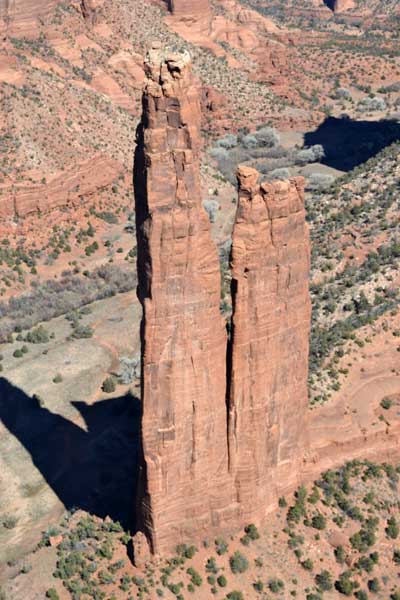
Then, it was to the South Rim drive. I made all of the stops at every vista point, picking up more artwork by other vendors. Good views at Tunnel View, Tseyi, Junction, Sliding House, and Face Rock. The best stop is with a view of Spider Rock, a holy site. I did my panoramas, then went back to the White House Overlook. I declined the trail, as I was tired, and you can see the white house well, with a telephoto lens.
 Back into Chinle, I had some food and drink, then continued south on U.S. 191. I arrived at Hubbell Trading Post National Historic Site just before closing, and went inside into the still operating store. There was more to see, then I stopped at the visitor center. Driving through rolling grasslands, I came to Interstate 40. Coming to Holbrook, AZ, I got to my motel, and had some more dining.
February 25 Saturday
Opting to see Petrified Forest National Park 2X, then coming to the south entrance, I set my camera to a lower setting. There were hundreds of specimens of petrified wood to capture. Behind the visitor center, I took the Giant Logs trail. Then it was to the Crystal Forest trail, then the Jasper Forest. Skipping the Blue Mesa, I stopped at the Tepees view, then to Newspaper Rock. There is a marker for Route 66, then there are more views of the Painted Desert to the north, with Pintado Point, and the best view at Chinde Point. After a stop at Tawa Point, I stopped at the impressive north visitor center, then came back to the Interstate.
Another busy day. I was running low on memory. I found that I had packed away another sizable card, so I was saved. I took AZ 87 north to Little Painted Desert County Park to see what was there. Backtracking south to Homolovi Ruins State Park, I went to the visitor center to pay, and then hiked at Homolovi II. I made some exploratory hiking at a stop, then took a quick hike to Homolovi I.
To the Interstate, I headed west. My next stop was at Walnut Canyon National Monument. I had looked for this site in 1978, but never then found it. I had good directions this time. I had arrived with an hour to spare for the trail hike. Passing through the visitor center, I started the loop hike. You get distant views of the early dwellings, then right past by some more dwellings. There are more views nicely captured with my telephoto lens, then it is up the stairs back to the visitor center. I barely had time to do the Rim Trail, saw some ruins, then exited the park.
Passing through Flagstaff, AZ, I headed north on AZ 180. You can still drive the roads after hours, so I got some photos of Sunset Crater, although the Sunset Crater National Monument visitor center was closed. There is an overlook at the Lava Flows. Making a loop drive, I entered Wupatki National Monument. I hiked to Wukoki Pueblo, where I waited for the sunset. I saw how native man liked this spot.
Back to AZ 180, I sought dining in Flagstaff, but was heavily confused by the streets, looking for some good dining. No good, quick, free Wi-Fi access, or good map. After wandering wastefully, I gave up and headed west on the Interstate. I got to Williams, AZ, where I had a simple burger meal. I rested at my motel, and had some slight sleep.
 February 26 Sunday
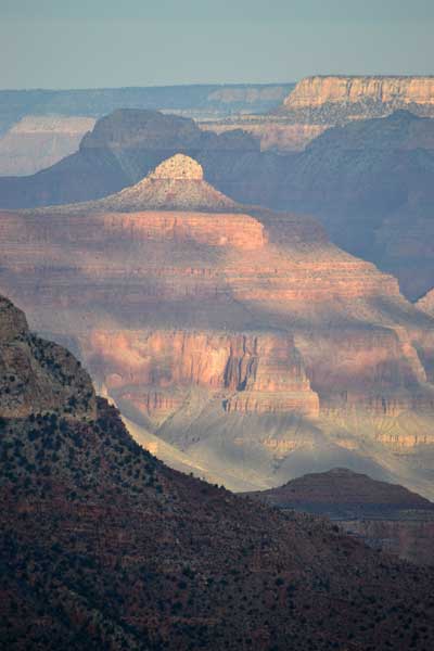
Up too late to catch the sunrise at Grand Canyon National Park, I headed north on AZ 64. Coming to the park entry, I started eastward to get photos of the major viewpoints. Grandview Point is said to be the best, so I spent awhile there. There is Moran Point, Lipan Point, and Navajo Point. From the big parking lot, I spent awhile at Desert View, going up the tower, doing some video and photos, and buying a souvenir. Backtracking west, I went to park my car at Mather Point, then doing a short hike loop on the Rim Trail, went by the visitor center and going inside, by the village.
Motoring on to the Bright Angel trailhead, I had a burger at the lodge, and then strolled over to the Kolb Studio House where I took the free hour long tour, as clouds had come over. It cleared, so I made more stops at another point, then took a short hike down the Hermit Trail to a primitive viewpoint. I couldn’t wait for the sunset, so took off back to exit the park. I had drink at a eatery, then motored south on AZ 64 back to Interstate 40.
Pretty tired, I made a stop in Seligman, AZ, for a sandwich, then made it to my motel in Kingman, AZ.
February 27 Monday
Getting up early, I headed north on U.S. 93. I stopped at a viewpoint, then passed over the Mike O'Callaghan-Pat Tillman Memorial Bridge. I stopped at the Lakeview vista point on the old Hoover Dam highway, then got back on the Interstate to complete my driving on all Nevada Federal highways by doing the Interstate 215 stretch between Boulder City and Interstate 15. Headed for Red Rock Canyon National Conservation Area, I took a quick stroll at the visitor center, with some sights either new, or what I didn’t remember.
Taking the scenic loop, I stopped quickly at Calico Hills, then to the highpoint of the loop. It was due to rain this day, but it looked O.K. for the weather, for now. I did the short hike to Lost Creek falls, then took the Pine Creek trail. Looking for more falls, I did some scrambling with a dry streambed, then turned back after ten minutes. I couldn’t hear any water.
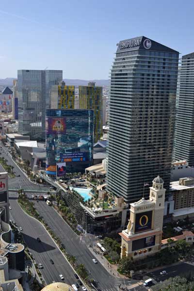
Back to the car, I made a quick stop at the major, free viewpoint, then took I-215 back to the Strip. Checking into my casino hotel, I left to go to the Palms. I had food, then motored back to my hotel. Buying a bus ticket for two hours, I rode to the Bellagio, where the fountain show made for a few video clips. With a few shots of the Strip, I went inside of the Cosmopolitan. Having a last view of Lake Bellagio, I then went to Paris, where I bought a ticket for the elevator ride to the top of the half scale Eiffel Tower. They cancelled the ride due to an expected storm, so I got a rain check good for a year. Going back to my hotel, I decided to extend my stay for a few more days.
 February 28 Tuesday
Up early, I drove over to the electronics store for a good deal on memory cards. Back to my hotel, I had a nice breakfast, and then rode the bus on the Strip for movie clips. I purchased a three day ride pass for $20, and was to make good use of it. The Bellagio Conservatory still had a Chinese New Year exhibit. Going to the Cosmopolitan for a light lunch, I did video, wandering a bit, and had to go to an ATM for more cash. Riding the bus back, I rested in my room, then rode back for magic hour to have some fine dining, go by the Conservatory again, look at the shops, get food and a drink in the Cosmopolitan bar, and shoot more photos and video.
February 29 Wednesday
Taking the bus, I went back to the Bellagio for a fine breakfast, did more photos about the Conservatory, walked outside, then on going to Paris, had to wait for a wedding before going to the top of the Eiffel Tower. I had meant to do this at magic hour, but decided not to wait. Figuring now not to stay till Friday, I went back to my room to cancel. They said that I could wait till morning to finally decide. Resting, I made one final dining trip to the Bellagio. Going back to my room, I went to sleep.
March 1 Thursday
Getting up just past midnight, I gathered my things and checked out. I got gas and coffee, leaving town at 1 a.m. Driving in the night southbound on Interstate 15, I felt good to make it home this day. I had figured to visit Death Valley National Park, but I have seen that most all, so many times. I took CA 58 to U.S. 99, with rest stops and coffee, then came home at about 10:30 a.m.
Summing Up
Out 13 days, I had hiked about 22 miles with 3,500 feet of gain. Some substantial wandering about the Vegas casinos and streets. Driving 3,266 miles, using about 80 gallons of gas, prices went from 3.219 to 4.139, for an enroute total of about $300. I captured a total of 6,903 images and movie clips. Spending about 880 dollars cash, I charged up about $480 for lodging and the $80 for my park pass. So then, about $1,500, total. I had also taken a pre-trip auto service with a repair, that ran about $250.
Wearing mostly three or four layers, double thick socks and trail runners did fine the whole trip. Gloves were nice at times. I didn't need to drink much water on my hiking, since it stayed pretty cold. I always wore a thick cap, with a thinner cap at times in the casinos and restaurants. One medium weight bottom layer under my jeans. I used three day packs, never using any spare clothes packed in my duffle. No bugs or mosquitoes, I used some sunscreen twice. Lodging every night, though I had a light sleeping bag along for camping in the desert. I had to wipe my nose a lot, with spare napkins from restaurants. Some nights, I got only a few hours sleep. Wi-Fi was alright, with slow connections at times, or even none at all. Had to call tech support once, with an excellent resolution.
I paid the most, for any single meal, ever, $50, to get a light, three dishes. Donating $10 to a homeless cause, I had a nice, low $3 fee for an ATM withdrawal, compared to $24, for the same amount, at a casino. I used the most memory, more than 53 GB, and didn’t lose a single image item on download. Spending $21 on Native American art, I picked up a DVD postcard for 10, and tipped 5 for two models to pose.
I intend to keep from too much more driving till Spring. Unless, of course, there are great ops for national park or national forest hiking visits. It seems that the waterfalls won’t be as good as last year, and I don’t know what to do, for sure, this summer. I have no peaks to climb, and figure on webwork to keep me occupied for weeks. I did a lot of 360’s and multiple panorama sequences, which take quite the time to stitch for my aging processor. Maybe a hundred movie clips to edit.
It’ll be back to Vegas in 2013 for the Linq opening, and to stay again for more dining. I inquired about videos while cruising along the Strip, and will then have quite the movie clips. As for the magnificent national parks, I’ll be using my pass, and plan to enjoy many more visits.
BACK TO PETE'S
THOUSAND PEAKS HOME PAGE