PACIFIC NORTHWEST PEAKS AND WATERFALLS LOOP July 28-August 4, 2012
 With my car and myself aging, I figured it was time for another summer road trip. I need to lose more weight, so some hiking and travel might do me some good. I didn't wish to make this too long of a trip, calculating about a 2,000 mile drive, but it was to come to nearly 3,000 miles when it was done.
Leaving home in late morning, Saturday, I headed north on Interstate 5. Having most of my motel reservations made beforehand by the Net, I was secure in knowing that I'd have some comfort, security, and Wi-Fi access during my nights. Some days were pretty ambitious in my hiking and driving times, but I managed to keep to my schedule.
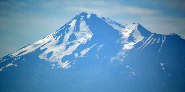
My first destination was the McCloud Falls. I took Highway 89 east from about Mt. Shasta City, CA, to the paved roads and parking lots that are well signed. Taking the short hike to the Lower Falls, many people were enjoying jumping into the pool below the falls. Daredevil feats, by me. I left all that out of my photos and videos, having to wait for swimmers to clear the scene.
Next was Middle Falls. Again, people were about the scene, and I set up my camera and tripod at a spot where I could get a clear picture of the falls. Finished, I left the area and didn't visit the Upper Falls, with no time. Seeing a sign for a view, I headed east a bit to a sight of Mt. Shasta from the southeast. Back to Interstate 5, I sought to get a nice photo of Mt. Shasta. I motored up the road to Castle Lake, and figured then to see it, too. There is a viewpoint of Shasta from about a mile below the lake parking area, then I went for a quick hike up the trail about Castle Lake. Stopping again at the roadside view, I took a few more photos, then headed for Yreka, CA, my first night's lodging spot.
Up early the next morning, I had to get to Portland, Oregon. I made great time on the freeway, so stopped in Roseburg, OR, to get information. There is a series of waterfalls along OR 138 to the Cascades. Driving up the highway, I stopped for a hike to the first falls, Susan Creek Falls. A nice trail leads through pleasant forest, and I took plenty of pictures and videos. Coming to the falls, I waited for people to stay out of my videos, and then got my movies. Having a wide angle lens, it is easy for hikers to intrude into my shots from the side.
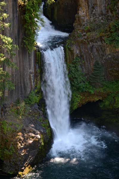
Back out to the highway, I declined to stop at Fall Creek Falls, seeking to visit the higher and better falls further along east on OR 138. I parked at the trailhead for Toketee Falls, and took the short trail to the point. It is classed as a beautiful fall, and it was worthy. I endured some road work delay, and got to the third falls, Watson Falls. You park at the picnic area, and hike up the trail. The sun had now come out, so the harsh light ruins the photography, with shadows and sun. I did my photos and video, then hiked back to my car.
Returning west on OR 138, I didn't have the time to stop at the many other falls, so I may have to make a return trip. A nice stop that I made was at a "Narrows" on the North Umpqua River. Passing through Roseburg again, I zoomed north on Interstate 5 to rush to Portland, where I beelined for my motel.
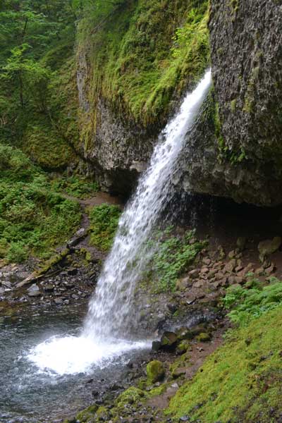 Monday, it was overcast, and I had some apprehension about the weather. I took the Corbett Exit on Interstate 84 to pass the Portland Women's Forum and the Crown Vista Point. Taking then the Historic Columbia Gorge Highway, I found that Latourell Falls parking area was under construction. Leaving it for another time, I came to Bridalveil Falls trailhead. A short hike down and up a trail leads to the viewing platform, and I did my camera work. It is a short hike up back to the cars.
I stopped for Wahkeena Falls, with a short trail to the fall, then back. I then came to Multnomah Falls for my fourth visit. I stopped inside the visitor center, hiked up the trail, did my quick record shots, then enjoyed an iced coffee at the java stand, then a bowl of soup in the Lodge. Comfortable with my trip now, I motored east to the last trailhead, to start a loop for Horsetail Falls. I came to the overhanging drop, and then followed the trail up to Oneonta Falls. This was disappointing, but I continued on the trail to complete a loop, hiking west down to the highway and along the road back to my car.
There are more falls along the way, but I cruised onto Interstate 84 and zoomed to Cascade Locks, OR, and crossed the toll bridge, the Bridge of the Gods. Making a short stop at the Columbia River Gorge Interpretive Center, I then motored on to the Forest Road north out of Carson, WA. This leads to various views, and winds through long stretches of trees. I had driven this road back in 1999, then not totally paved, taking a shortcut. Then missing a hike to a falls due to not having a forest pass, I corrected that oversight this time, but anyway now, the parking is free. Beforehand though, I detoured to Windy Ridge in Mt. St. Helens National Monument, with a nice scenic drive with numerous vistapoints. Not doing any hiking due to lack of time, and having done some here already, I motored back down the scenic road through more ancient forest.
Coming then back to the paved forest road, I did the short hike to Iron Creek Falls, and it was worth going back for. Motoring north to U.S. 12, I saw a sign for Cowlitz Falls, so made a investigation. I came to a reservoir, took some photos and left. Back to U.S 12, I headed west to Interstate 5, and then north to Centralia, WA, for food and lodging.
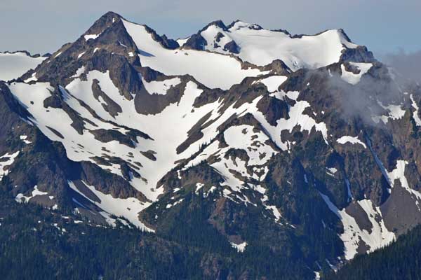
Tuesday, I had my first peak to hike. Taking U.S. 101 north, I passed along the Hood Canal, a long, arduous drive, and then came to Sequim, WA, where I stopped for a break at a vista point. Motoring on, I stopped at the visitor center on the Hurricane Ridge road in Olympic National Park. Entering the park, I motored up to the trailhead parking without a stop, and began my hike to the top of Hurricane Hill (5,757').
They said the wildflowers were at peak, so I made sure to get photos. The trail is paved all the way to the top, hardly a challenge, but the views of the Olympics were gorgeous. Many hikers were at the top, so I shot some video at the lower vista points. A fine day for the area, I timed my visit right. There are trees at the summit, so they block any 360's from the toprocks, but I captured the views, and then hiked back down the trail.
 Back at the visitor center, there were more deer to take videos and photos of. On the park website, warnings are made about mountain goats, who follow people and even kill hikers. They are said to have a craving for urine, so I made sure not to leave any. I was able to always use a facility on this entire trip.
Back to U.S. 101, I had some more sights to see. I made a short side trip to Madison Falls, an easy walk. Then, driving along the highway west to Lake Crescent, with a hike to Marymere Falls, made a pleasant diversion.
Motoring back to Port Angeles, WA, I looked for drink and food, but shortly left. I took a shortcut to Tacoma, WA, crossing a bridge on WA 104, then mostly freeway along WA 3 and then to WA 16. Over the Tacoma Narrows Bridge, I searched for my motel by my old memory, and then had to get some food to use a restaurant Wi-Fi connection to get the directions. On a diet, I ate lightly for most of the trip.
Wednesday, I woke up at a good early hour. Taking freeway to Highway WA 164, I was driving slowly with little traffic, to see a waterfall along the way to Mt. Rainier National Park for my second peak. I took the side road to Sunrise, and parked to start my hike to Dege Peak (7,008').
Slathering on sunscreen, there was a field of wildflowers and plants, then a trail traverse with views along the way. With about 100 feet of drop, I came to the trail junction with the trail to the top, then shortly summited. I had the top to myself, so began with my 360 and views, and videos, with only distant road noise to be captured by my audio. I was able to relax and enjoy the views, then do some more leisurely videos. Other hikers were coming up, so I returned to the parking lot, stopped by the visitor center, and got some drink at the snack shop.
Motoring down the highway back to the main park road, I took a detour over Chinook Pass on WA 410 east. One of my trip objectives was to complete driving over all of the major highway passes over the Cascades, Sierra, and Desert, and this was one of the ones that I had to do. I came to the trailhead for Union Creek Falls, where I had to pay $5 for the day use. A trail leads to the creek, where the bridge is washed out. I expected that you can see the lower falls from here, but I had to do some precarious scrambling to get to a sight of some falls, so I took photos and video. There are no signs, so I don't know for sure if these were the Union Creek Falls, and there is a falls higher on the trail. I could have crossed a log to get over the creek, but I declined, so hiked back to the car, and drove back west up WA 410. I took photos at a good view of Mt. Rainier.
Making a semi-circle south to U.S. 12, I stopped at a vista point, then drove over White Pass. Another pass to drive for my highway list completion. Clear Creek Falls makes for a nice view, and then it was east on U.S. 12 for more sights, and then to Yakima, WA. Enjoying a long evening, I found a nice eatery for a dinner salad and dessert by my app, and took a short walk about historic Yakima.
 Deciding at the last moment to make a long side trip out to Eastern Oregon, I woke up early to head south on Interstate 82. It is a long drive on Interstate 84 to La Grande, OR, where I filled up in preparation for a checking out of forest and backcountry roads. Taking OR 82 east, I passed through various small towns, to pass through Joseph, OR. I motored on to a view of Wallowa Lake, then back to Joseph for some quick photos, then back to the Imnaha Highway northeast. I wanted to visit Hat Point (6,982'), a magnificent view and peak, by me, since it is a highpoint.
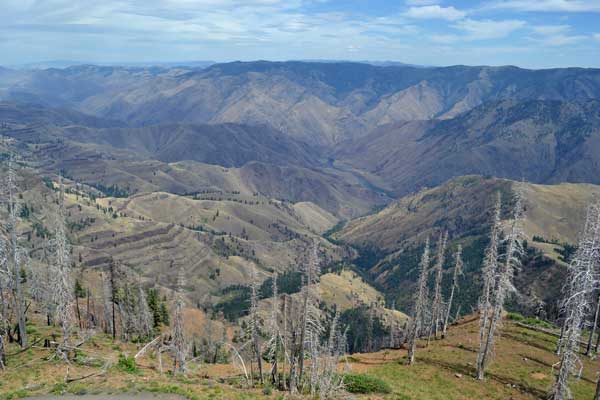
Coming to the end of the paved road, I had been told that cars could make it up this primitive road. It does take some time, but I drove slowly and carefully. It is a total of 24 miles to the top, and the first 7 miles is signed steep and narrow. I kept in low gear as I climbed in my vehicle, and even considered backing out. I knew that high clearance is recommended by some, but motored on, since I am good with poor roads. It became steep, and I had to pass a truck coming down. There is a section which sides along a very steep slope, essentially one lane. It gets rough, and I had my doubts. Persevering, I continued on, and reached the high ridge, where the road gets better. There are a few views along the way. With less uphill, then, I even put it into third gear, and motored along, but not sure of any more steep sections ahead. It does drop a bit, but the road is good up here. I stopped at Granny Vista for a short walk on paved trail, and to do some photography.
Finally coming to the road to the lookout on top, I parked, and started a short hike about the trails circling the highpoint. I gained the magnificent views, and started with photos and videos. Then climbing the lookout tower stairs, I lounged on the platform high above the ground, and did more photos and video. The lookout was having lunch, so I wasn't able to go to the highest lookout level, but I don't require going to the top of any man-made structure to claim an ascent.
Spending about an hour here, I left to drive back down the road, with videos (92.2 MB, 640 x 480 pixels, 4:34) to do as I drove. A van then blocked my way in the steepest, narrowest section, and it proceeded right up to my stopped car. The driver refused to grant me the room I needed to pass, so we had a talk, and fortunately, a child got out to direct the driver to the edge of the roadway, giving me the room to get by. I stayed in low gear, as signs advised, to avoid brake failure, and finally returned to pavement at Imnaha. The driving day wasn't over!
I wanted to drive Forest Road 39 to Hells Canyon Overlook for another vista, but at the road junction, a sign advised, "Rough Road." On the spur of the moment, I turned around, as passing SUVs then seemed to give me a look. My AAA map shows it as paved, and my memory of what I was told was weak. Typically, a phone call to the Forest Service connects me with ignorant office workers who don't know anything. Someone later told me that it is a 4WD road. I kept conservative and drove back west on the Imnaha Highway and then to OR 82 back to La Grande. That gave me another 70 or so miles to drive, and another overlook that I may have to return to visit. But better this than getting my car stuck or ruined.
From the Interstate, I had another 100 or so miles to drive south to my motel in Ontario, OR, and I bemoaned my loss of ops to explore, but better safe than sorry. I got drink and food along the way, and saw this freeway for another time, since my trip back in 2004. But my trip wasn't finished by any means!
 Thursday, I had a long drive to get to Bend, OR, by U.S. 20, another roadway I wished to drive. It passes through desolate country, with sagebrush buttes and hills, not much to see. Curious about how it all looks, I satisfied my hunger for photos, with a break in Burns, OR. There are distant views of the Cascade Sisters as you approach Bend, and then, I was there.
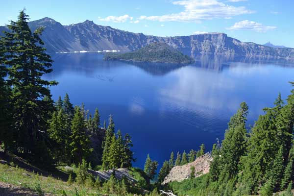
Taking U.S. 97 south, I wanted to hike a peak in Crater Lake National Park. Many electronic signs advised that OR 58 is closed at night, but I had already crossed that pass the year before. I motored along at good speed, then passed by a runner event along OR 138. Going into the park, I didn't stop till the trailhead, as I have seen the usual views many other times. I'd get the best views from the top of the peak.
No signs indicated the Garfield Peak (8,054') trail, but I had looked at my maps, and gotten the information by the Net. Passing the lodge, I hiked up the trail, and came by some workers who said that they had just opened the trail by clearing a route through the snow. I had been denied permission to do this peak another time, so this was a "grudge peak."
I gained new views, for me, of Crater Lake, and continued up the trail. They had dug some steps in the snow, to be better for hikers, but I could have easily gone over the angled snow with my climbing skills and ice axe, if this had been the only difficulty the time previous. Tourists will leave the trail and go over fragile terrain, to cause erosion. Many use trails scarred the hills along the way, but I do not do that when it is illegal.
Topping out on the level summit, I started with photos, and as other hikers quieted down or left, then did some video. Taking about three hours total on this hike, I enjoyed the late afternoon light, and took more videos as I hiked down the trail. Back to the lodge, I looked for a dining op, but they didn't have what I wanted, and the prices are high. Low on gas for some reason, I motored to the Mazama Village, but didn't get any more gas there. There is an Annie Falls along the way out, making for a distant sight, then I was back to U.S. 97 and motoring south.
Into Klamath Falls, OR, I quickly navigated to my motel, and got my room. Finding an excellent restaurant by my handheld, I waited till dusk, and then got my best meal of the trip. My hiking was over. Four peaks, then.
My last day out, Saturday, I took OR 66 for my last set of passes and highway to drive for my list completion. It isn't an especially scenic highway, but I enjoyed the drive, stopping at the Applegate Trail park along the way. There was another pass to go over with a scenic view. Taking the historic Siskiyou Highway back to Interstate 5, I did some video with only mainly cyclists enjoying this tree lined route.
 Zooming over Siskiyou Summit, I was stopping at Yreka for a break, and thought of another peak or hike to do before ending my vacation road trip. This area is close enough to home that I can easily return some other time, if I wished to do a repeat. I couldn't think of anything that worthwhile to keep me from my computer! With a few more stops and breaks, I was home in late afternoon.
Hiking then some 22 miles with 4,100 feet of elevation gain, I had driven almost 3,000 miles. Using about 71 gallons of fuel, paying from 3.359 to 3.779, I paid about $253 enroute for most of the gas used. Capturing over 3,400 images and movie clips, I spent nearly $800 total, with about $325 for lodging. I used only 4 memory cards for my cameras, some 29 GB total used, and kept the camera batteries charged during every motel night.
Bitten by mosquitoes once or twice, there were never enough of them to apply repellant. I wore shorts or jeans, and at most, my Hoody with a T shirt. I saw many deer and birds, and few dogs at all, being mostly hiking inside a national park. Also, there were a couple mountain bikers, with no hiking conflicts with Jeeps or SUVs. Hiking mainly midweek, I always got parking at the trailheads, with plenty but polite enough hikers. I had worries about my car, but it performed admirably. Being in a rush, I ate a lot of fast food, with fish and breakfast sandwiches, with mostly always a dollar drink. All in all, it was a fine trip, with no undue problems, and all hiking went as planned.
Not feeling particularly fit with just light hiking done, I didn't lose a lot of weight as in years past on a strenuous peak climbing trip. I dined well some nights, and enjoyed my motel stays with good connections.
With more driving done than I calculated on planning this drive, I may not do any more longer peak trips this summer. I'd like to hike more, but it may have to be locally. So now, I have done some peaks that I had in mind for a long time, and completed my highway passes list that might impress some travelers.
BACK TO PETE'S
THOUSAND PEAKS HOME PAGE