FALL 2012 SOUTHWEST LOOP September 30 to October 9, 2012
 With another spate of rising gas prices, I had planned to try New England for a fall colors adventure, but it sounded like too much. I’d have to fly for the first time in decades, rely on my new hardware with which I had little experience, and to be in highly unfamiliar terrain. Better maybe in 2013, when they have the Freedom Tower completed for the new urban views, I opted to head back to the Pacific Southwest. I had little new to see, being that I was going for the photo op. The forecast in many areas was for partly cloudy, so I might have interesting light.
September 30 Sunday
Waking up at an alright hour, I made ready with my things, and left home by about 8:40 a.m. Taking Interstate 80 eastbound, I got gas in Auburn, CA, at 3.919 (per gallon), and zoomed with a stop at the Donner Summit rest area, where they have a new trail. I continued to the Patagonia Outlet in Reno, NV, where I had some $12.50 salmon jerky for lunch, and bought a new hat.
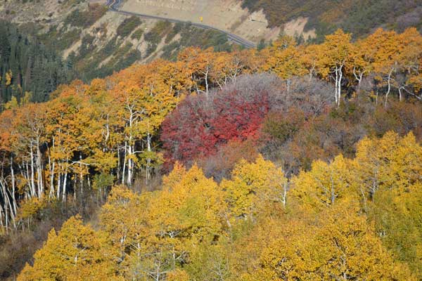
Occupying the time with photos with my new camera, I made good time passing the usual freeway exits, with stops and rests. Finally coming to Elko, NV, I had the time to visit Lamoille Canyon. The fall colors were about 40% turned, but it was late afternoon. I took a short trail, went to Road’s End, then returned to Elko. Enjoying a nice prime rib dinner, I uploaded the first of many photos to my Facebook page.
October 1 Monday
I surfed the Net, getting information, using my tablet and handheld, then took off to go back to Lamoille Canyon. The morning sun hit the slopes, and I took my record shots. Managing with no traffic to do some video, I liked this vacation. I drove back to Interstate 80 eastbound to exit at Wells, NV, to take the road to Angel Lake. There was color, and I walked out for a panorama of the lake. I had more photo and video ops, then I zoomed east again.
Coming to the rest area past the Salt Flats, I took a short hike to the top of a small hill. There is a small arch which had been vandalized. I continued to Salt Lake City, where I took West Temple and had a burger for lunch.
Now, I was heading south on Interstate 15. I took the exit to the Alpine Scenic Drive, UT 92. Reports said that color had come early to the Wasatch, so I checked this out. I did more video, and stopped for a few photos here and there. Back to the Valley, I drove through Provo, then continued south on the Interstate. Lodging in Nephi, UT, I uploaded my day’s work to Facebook, with a message to the Forest Service webmaster about my fall colors images.
October 2 Tuesday
 Seeking new sights with a new road to drive, I took UT 132 to UT 116 east. North for a short way on U.S. 89, I headed east on UT 31, the Energy Loop. I ran into glorious fall colors, and stopped at a couple good vistas for photos. Electric Lake made for some more photos. There was a stop for views and information about the Huntington Canyon power plant, with coal trucks busy with loads from a nearby mine.
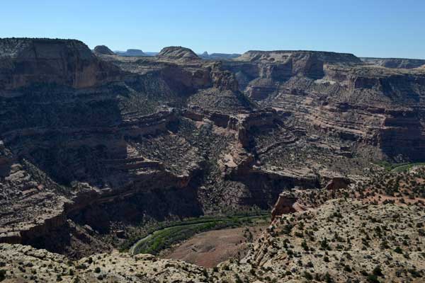
A shorter drive south on UT 10 brought me to the turnoff for the Green River Cutoff. This is a dirt road that bisects the northern San Rafael Swell, with sights to see. Motoring slowly through desert country, I soon came to the turnoff for the Wedge. It is another six miles of good dirt to the view of the Little Grand Canyon. I stopped for photos from the Wedge Overlook, then motored further to the overlook along a prow of land to one of the most spectacular new views that I had ever seen.
Getting a signal, I uploaded a few images to Facebook, then left after about an hour here. The main dirt road swings south into the Buckhorn Wash. Having the road almost solely to myself, I did some video of park worthy sights as I drove along. A stop at the Petroglyphs netted some new photos for me, then it was a bit further to the swinging bridge over the San Rafael River.
Now, I had to finish the drive getting to Interstate 70. I had information that this road was good, but there were a few rough spots, and washboard. Some drivers coming in this way might turn around. I drove so slowly, then finally approached the freeway. Onto the Interstate, this was a good driving adventure.
It was 75 mph to Green River, UT. I just had a sandwich for dinner, then struggled with a spotty connection. The motel free Wi-Fi started working, so I was then delighted.
October 3 Wednesday
Up early, I wished to reprise my photography of the sunrise at Grand Viewpoint in the Island in the Sky District of Canyonlands National Park. I had plenty of time, and had the area to myself, once again. I did my photos, with clouds in the sky, dawdling with my uploads by my cellular connection.
Stopping by Buck Canyon Overlook, I hiked to Mesa Arch for more photos and video. Then, by Shafer Viewpoint, I headed back along UT 313 with two more photo stops.
Having a nice breakfast in Moab, UT, I could now relax. I was in Southeast Utah! I motored south on U.S. 191 with views along the way. Taking UT 46 east, I made photo stops of the colors in the La Sal Mountains at two forest access roads. Headed back north on U.S.191, I managed to get a few more photos of the La Sals from another access road.
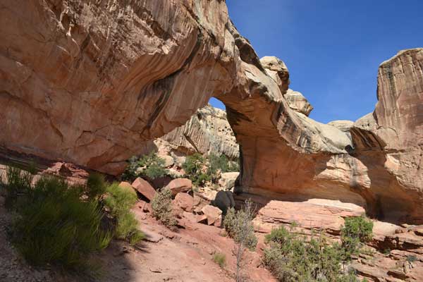
Then, I entered Arches National Park. Stopping first at the Park Avenue trailhead, I drove to Double Arch, then to the Devils Garden trailhead. I hiked on the trail to Landscape Arch for photos with the sun behind the arch.
Hiking straight back, I motored over to the trailhead for Delicate Arch. Hiking up the trail with many other hikers, I’d try to get another great sunset photo for my fourth attempt. About a hundred other hikers waited at the arch view, with many posing under the arch. I had my cameras to shoot the scene, and the light glowed orange, but not deep red, as is nice. Hiking back down when the show was over, I came back to my car before complete darkness, and motored off, heading back to Green River.
 October 4 Thursday
I had a longer but easy driving day ahead of me. I was able to sleep a bit more, then headed west on Interstate 70 to UT 24 south. Coming then to Factory Butte, I snapped many photos ahead on this scenic highway.
Taking a hike along the Fremont River at the start of the trail to Hickman Bridge, I shot video and photos. The trail goes shortly to the bridge, and I completed the loop under the bridge, and sauntered back to the car. Having made the other Capitol Reef National Park photo stops, ahead, last winter, I then took UT 12 southwest. The fall colors were a bit past peak, but I made my photo stops at one vista point, then another.
I liked to make a photo stop at the Hogsback, but the interpretive signs were no longer there. I shot the views of the Grand Staircase-Escalante National Monument, then made a photo stop at another vistapoint on the west side of the Escalante River. Heading still west and having lunch in Escalante, UT, I motored on with more photos ahead. There is a high viewpoint by a high, 9,600 foot summit, then I continued with more sights ahead.
Still on UT 12 now, I took a side trip to Bryce Canyon National Park. I made stops at Sunset Point, Inspiration Point, and Bryce Point. With a good signal, I sent my photos to Facebook, again. Only one person likes my work, with the others not commenting, or I imagine, simply not interested in my travels. I see it all as gorgeous, with photos shot and then sent within minutes, but I suppose that most are then not online to view them, right away.
 I motored back to UT 12, then to U.S. 89 south. Turning west on UT 14, I passed by some pronghorns grazing by the highway, but short on time, I refused the photo op. Navajo Lake made for photos, then I came then to Cedar Breaks National Monument. Strolling out to the view, I took my photos, then, cold and windy, I left to head back to UT 14. The Zion Overlook made for a nice sunset photo op. I then came to Cedar City, UT, for food and lodging.
October 5 Friday
Now a weekend, I couldn’t get lodging in advance except for northward in Beaver, UT. I took Interstate 15 north with a speed limit of 80 mph in the dawn light. I stopped at the ranger station on the main street to get information and to check in, then finding that UT 153, my approach highway to my climbing Delano Peak (12,173’), had a long detour due to road construction.
I took the scenic highway, with reds, then took the detour, the Kents Lake Road. I made some stops for photos, with Kents Lake, then Upper Kents Lake. Coming to a couple more sights and reservoirs, I then came back to the main highway, UT 153. Unpaved, the going was slow. It was approaching 11 a.m. I saw that I didn’t have the time to do the peak, and get back to the Beaver USFS Ranger Station to let them know, before their closing, that I was safely back.
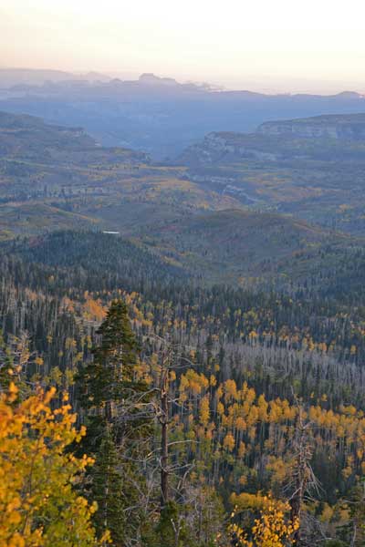
I saw another trail op, a Skyline Trail, so I parked and took that. Hiking up the road, I then took the signed trail towards Big Johns, signed 8.3 miles. I forgot my topo maps, but I’d hike by the clock, and try to see some views. The trail had groves of bare leafed aspen, with fallen leaves on the trail. I slowly hiked on up, and kept track of my time. Reaching some views to the east, I came to the top of a slight hill, in the forest. Turning back at 12:40 p.m., I’d take my time hiking back.
Back to my car, it was later to be seen that I was over 10,000 feet elevation. I found no signal or service, so motored back to the Kents Lake Road detour. I had time to shoot some video. Low on gas, too, I was glad that I had not tried the peak. Missing a photo op for mountain goats, I must try to get back here sometime, as this was an easier peak. I snapped a few more fall color photos, with Kents Lake again. Back to the regular UT 153, there were more photos to take.
I returned to the ranger station with plenty of time, and looked at a topo map to see where I was. I came to my lodging in town, and relaxed further. A sandwich made for dinner, as I didn’t imagine dining ops would be very good. I uploaded more photos, and went to sleep.
 October 6 Saturday
Motoring south on Interstate 15 in the dark, I passed through Cedar City again. Taking UT 17 south, I took the road into Zion National Park. My park pass made for another great deal.
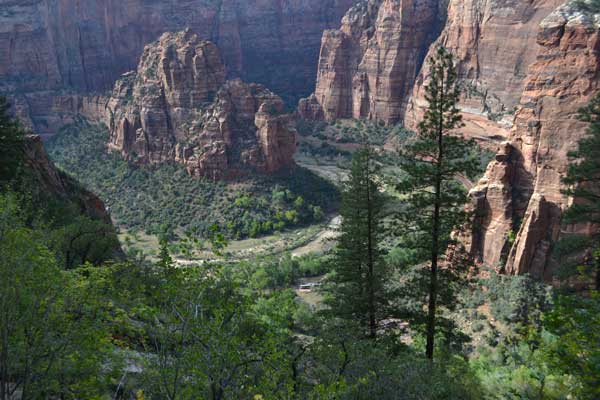
Parking at the visitor center, I took the shuttle bus to my trailhead at Weeping Rock. Starting up the trail to Observation Point, this would be my 3X for this magnificent viewpoint. I shot photos and video of this beautiful trail, with narrows and views. I met another hiker who knew me, and we spoke for a short bit. Continuing on, I noted about 50 hikers who chose to do this point.
Arriving to the view of the canyon below, after about three hours of lazy hiking, I started with my photos and videos. I had plenty of time, so shot the views with clouds and changing light, and looked for condors. I saw some large birds in the distance, but they may have been hawks. With my telephoto lens, I could see hikers on top of Angels Landing. I sent off more images to Facebook, and assisted some with their own photos.
Starting down at about 2:50 p.m., I did close ups of the wildflowers by the trail. I shot more photos as I hiked down, with dramatic light of the canyon as I approached the end of the trail. I caught the bus back to the visitor center, and motored off. Taking UT 9 east, I was able to stop for videos of some bighorns crossing the highway.
I had dinner at Carmel Junction, UT, then motored on U.S. 89 south to the road to my campground at Coral Pink Sand Dunes State Park, where I had reservations. There was a spectacular sunset, then I slept in my car. I didn’t get any signal, so my planned cellular connection went to waste. I was pretty tired, anyway, so I fell asleep early.
October 7 Sunday
Waking up by about 3 a.m., I had some cold coffee, then motored off. My destination was the North Rim of the Grand Canyon. Driving then at night, I passed through Jacob Lake, AZ, which was closed. Entering the park, I headed for the lodge. I could get a cappuccino, then motored off to Point Imperial for the sunrise. Some other photographers were here.
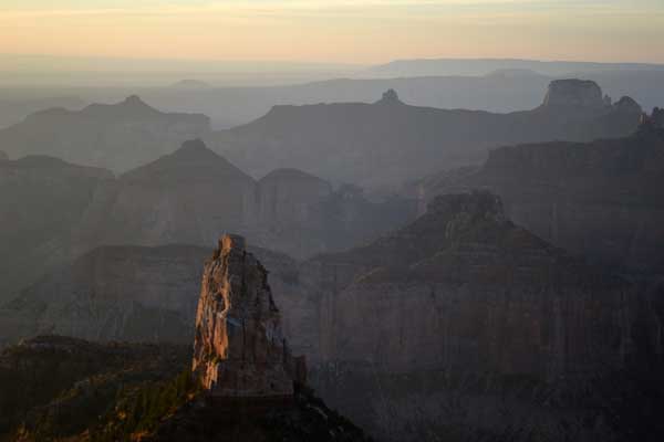 I drove over to Cape Royal, too, and shot more photos. Driving out, I did video of the forest, and then arrived back to the North Rim lodge. I dined with breakfast, then used the cellular to upload my photos to Facebook. I hiked out to Bright Angel Point, where I did panoramas and video.
Lounging in and by the lodge, I uploaded even more photos, went by the visitor center, then wandered over to the campground. The camp store here had free Wi-Fi, so I used it. Others had the same idea with their laptops. I had some drink and food from the store, then hiked to see the sunset from the Transept Trail. Falling asleep early again, I was getting bored.
October 8 Monday
I got up early in the dark, again, so resolved to head for Las Vegas, NV. I had seen and photographed the views, and though I had found out about more views outside of the park, declined them. Catching the dawn passing through Hurricane, UT, I took Interstate 15 southbound. The Virgin River Canyon made for sights, then I was cruising into Nevada.
I had to finish driving the new Federal highway, Interstate 515, from Interstate 15 to Interstate 215, to be able to continue saying that I have driven all of the Nevada Federal Highways, after doing the new sections by Carson City, NV, when it opens.
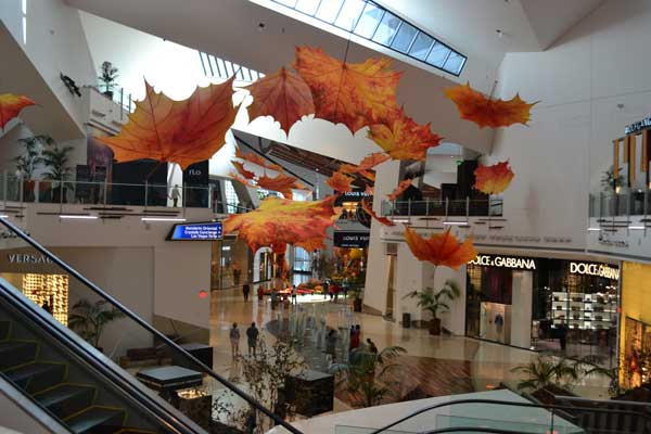
Coming then to the Strip, I parked at the garage for the Aria to take the monorail over to the Bellagio. I walked on through the super deluxe casino to the Conservatory, where the motif is Fall. Looking for fine dining, the cafe had a line, and other places were still closed. I rode the monorail back to City Center, then the Aria, and left for my economy lodging.
Check-in was not till 3 p.m., so I left for things to do. I had found that the casino that I like had higher rates, but found a ramen shop to have some lunch. Then, it was to Red Rock Canyon National Conservation Area. I stopped at the visitor center and chatted with the help. I took the scenic loop road, then it was time to head for my motel. I was suffering from lack of sleep, so lay with my devices in my room, and had some snacks before I went to bed.
 October 9 Tuesday
Not in the mood to stay in town, I declined to stay another night. Room rates were up. I’d head home. By the Net, the fall colors had not yet peaked along U.S. 395 in the Eastern Sierra, so I’d save my time and money. Leaving the motel at 3:30 a.m., I got gas at 3.779, then took Interstate 15 south and west. A nice breakfast stop in Baker, CA, was followed by plenty of diet drink and speedy driving to CA 58. Northward on U.S. 99, I inadvertently took CA 152 west, but returned to 99, by CA 59, to Merced, CA. With more food and rest stops, I ended my road trip in mid afternoon, coming home after a drive of 3,089 miles.
Hiking about 21 miles with 4,200 feet of gain, I spent about 585 dollars cash, with maybe 340 dollars charged for lodging and camping. Paying $316 enroute for gas, I perhaps used 80 gallons, running from 3.779 to 4.549. I spent $51 for a service and inspection right before the trip, with a whopping $1,440 for new devices and accessories. These, though, will greatly assist my travels and all for years to come.
Mostly wearing jeans, I donned up to four layers on the Skyline Trail and while camping on the North Rim. I had a summer bag for my nights outside, and usually wore a hat. I misplaced my Synchilla cap while at the North Rim, the only warm headwear that I used on this trip. I never saw any mosquitoes, ticks, or any other harmful insects that might bite and thusly infect. No rain at all, or fierce winds.
Pleasantly surprised at the extent of connectivity as I traveled, I didn't use much of my data plan's 3 GB limit as I used the motel and other Wi-Fi. I was too tired to use the Web as I slept while camping or being without speedy signals. If I had received an signal, though, I would have stayed up to be connected. Though mostly short on time, I know now that I have plenty of Web surfing to utilize the next time that I go out.
I’lll be traveling more this season, intending on using my still excellent vehicle and toys. Gas prices are due to come back down, and I love to explore dining ops out of town. I didn’t slim down very much, but I do feel better. I captured 4,794 images and movie clips. My health is becoming an issue, and though I still have no partners, I’m having my hiking and traveling fun.
BACK TO PETE'S
THOUSAND PEAKS HOME PAGE