MT. FILLMORE (7,716’) 4X, PILOT PEAK (7,457’) 2X August 13, 2011
 Wishing to try some easy peaks in the Northern Sierra, I received a message from the former companion whom I wished to discourage. However, the lure of an update for my peaks guide, to do some dining in Marysville, CA, and to revisit La Porte, CA, was just too great. He says that he is working on the “Ogul” list, a compilation of 63 peaks about the Northern Sierra. Since I considered it a dead list by a dead peak section, I had gone on to do other things. I had only a handful of peaks to repeat, to finish my 4X list completion, but as no one is interested, put it on the back burner.
He came by with his 4WD at 7:05 a.m., Saturday, and we motored north out of town on Interstate 5 to take CA 70 to Marysville, CA. To CA 20 east, we took the side road north to Brownsville, CA, and then the La Porte Road east. Seeking drink and food, we found that the old Union Hotel was closed. Going then to a small cafe, I had a tiny soda and potatoes, with my companion impatient about his time.
I sought to check out a road that was now the prospect for leading to the peak. The new highway, the Quincy-La Porte Road, is a recent improvement, seen by me, first in 2003. It obliterated the former route, and I was unable to check it till now. I knew that the road to Mt. Fillmore was a bad road, although I had driven it three times in my old passenger wagon.
That was right. I wouldn’t want to drive it in my present vehicle, although I might make it. I kept notes as we drove along, and it wasn’t so bad, better than the older way. There is one steep section with rocks that must be climbed on the way out, possibly trapping poor autos with low power and low clearance. It was finally to the roadhead, and as this is an easy peak, I felt we had done it.
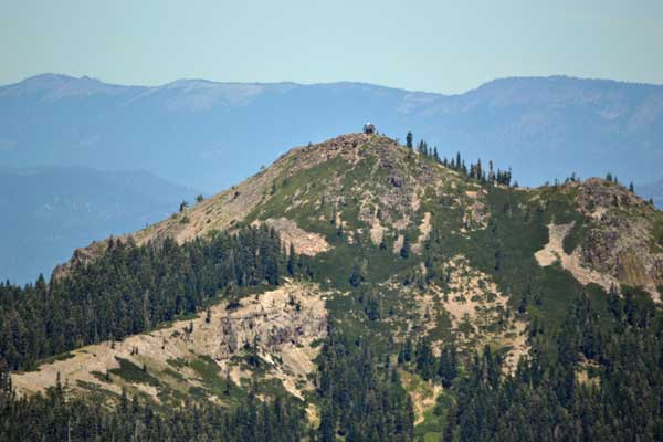
Hiking up a short dirt road as described by my peaks guide, I looked for the use trails as we had seen decades ago. Fallen tinder and weather had wiped them out. I saw a pair of footprints, and then we detected a trace of a use trail. Coming to a short cliff band of knobby agglomerate, I checked out old memories for a short scramble. A unique tree was still there. We circled about to the right to avoid some short, easy, class 3 scrambling, and then found a better trace of the use trail. It was overgrown, in 20 years time, and only someone like me would find it. I tried my best to follow it, and it led me along the ridge to the top.
 Summiting in 1.5 hours, I proceeded to capture the view, and my partner looked at the register. Few have signed in. I had the notion of bagging three peaks today, if we had left earlier. My companion became envious of the number to do, being that he regards himself as a good peak hiker, but I wasn’t feeling so good. From my old notes and memory, it had taken us 25 minutes to bag Mt. Etna (7,163’) to the northeast, but it is not a listed peak and unworthy of my effort, today. We started to have disagreements, and he left the summit area, me to have to follow. I felt it better for me to relax and enjoy the nice views atop Mt. Fillmore, and to take our time getting home early.
Descending, I became off route slightly, and he had no notion of our doing such. Not someone that you wish to navigate or climb alone. He changed his mind as we got back to the car, but Pilot Peak was still a possibility. Because he is a novice backroads driver, and the vehicle wasn’t the greatest for bad roads, we figured on heading back to the paved highway, and doing Pilot Peak from a more certain direction, which I had hiked back in 2003.
Getting to the right road, he started his drive up the rough and rocky byway. There is no good place to turn around, and it started to be too rough for him. I had to guide the tires around some high rocks, and then we continued on, trapped from turning around. Luckily, the road didn’t get much worse, and we came to better road and a saddle above. He had enough, so parked. We could have driven on easily, saving a half mile of hiking, but he doesn’t listen to me.
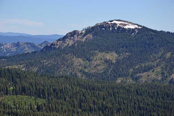
Hiking up the road, we came to a junction to another road going right, up the peak. Other trucks had gone higher, and a van was blocked further along, by snowbanks. I had to kick steps up a slight snow slope, then we came to the last section of foot trail that leads to the top. From there, the lookout is some 100 feet higher.
A large group was conducting their activities, so we stepped up the lookout stairs, some missing and some looking weak. I was glad that they held my weight. I captured the view, and the group began to leave. I wished to relax, enjoying the view, again. Some people dislike sitting and staring at distant mountains, and I wished to do my photography. My companion headed down the hill, and I’d meet him back at the cars. I did some standing glissades, awkwardly, and safely made it down to the lower road. There was a wildflower bloom, and I shot some close-ups.
Back to the car and my driver, we motored back down the road, and reached the paved highway. Since he likes dinner with his family, I missed my dining, but with so little exercise, I could wait till home.
Since I had been zigzagging looking for use trails on Fillmore, I’d say we did 6 miles total, with 1,600 feet of gain. I captured 239 images, no movie clips. The drive is roughly 250 miles.
This set of hikes didn’t contribute much to my confidence or conditioning, and I think that I am better off hiking alone. No respondent by the Net has proven compatible, and while I am open to more peaks, am reminded of the hiking club that I had paid to join. Now worthless for mountains to climb. I go to have fun, and there are those who seek to spoil it all!
BACK TO PETE'S
THOUSAND PEAKS HOME PAGE