 Buoyed by
having a game hiking partner now, we began to look to more peak
trips. I had another long lunchtime meeting with my new associate,
and was finally able to use my computer software to chat via the
Net, saving me big on my phone bill.
Buoyed by
having a game hiking partner now, we began to look to more peak
trips. I had another long lunchtime meeting with my new associate,
and was finally able to use my computer software to chat via the
Net, saving me big on my phone bill.MISSION PEAK (2,517') 4X March 14, 2009
Buoyed by
having a game hiking partner now, we began to look to more peak
trips. I had another long lunchtime meeting with my new associate,
and was finally able to use my computer software to chat via the
Net, saving me big on my phone bill.
Arranging to meet again, this Saturday, we carpooled to Fremont, CA, and decided to try the Stanford Avenue trailhead to this prominent Bay Area mountain. I enjoyed stopping enroute for drink and a bite for breakfast, then we started hiking at 10:50 a.m. Lucky to get a spot in the limited parking area. Many hikers were coming from another parking op further down the street in this opulent neighborhood.
Streams of hikers were descending and climbing up the dirt road. I got a crimp in my leg, but it went away. We huffed up the road, and I looked at the overcast sky. It was a bit chilly with wind, and I began to get cold. A mistake not to use polyester bottoms under my pants. Beginning to warm up after awhile, we gained the cloudy vistas of the South Bay. All the luxury homes!
The dirt roads weren't damp or muddy at all, I'd say bone dry. I had only my light pack, and our first plan was to traverse to top Monument Peak, as well. It was further than I thought, and it began to look like rain. I kept on my four layers but other hikers were in shorts and T-shirt. A tough, or not too bright, bunch!
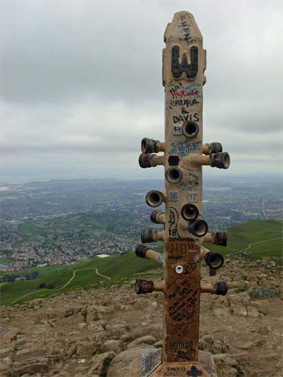
We topped out at 12:13 p.m., and I snapped photos. We got out of the wind, and I made myself comfortable with a view to the east. Mt. Diablo was in clouds, and sunlight occasionally broke on distant towns, including San Francisco. I offered to either wait for my pal to go over and hike Monument Peak, or even to drive his car and pick him up at another trailhead. I thought of a plan to climb another small peak by Napa, CA. That sounded good.
We started down from the top, and I shortly got warmer, being out of the wind. Some paragliders, then a hang glider soared above and to the west. The vast urban scene below us always impresses me.
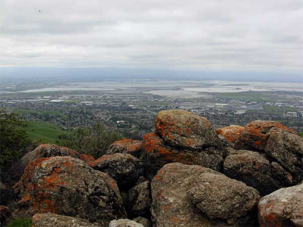
An outhouse served me well, and our hike back down saw some nice rocks with lichens as photo ops. We spoke with the glider pilots, and wondered how cold they were.
Back to the car, my idea was to get drink and another bite at the fast food outlet along Mission Boulevard. We motored back north on Interstate 680, then the sky cleared a bit. It looked fine for hiking a second peak.
Going north on CA 12, I navigated our route to Imola Avenue and then to Skyline Park. The entrance fee was now $5. The park closes at 7 p.m., giving us only 3 hours to bag the peak and get back to the parking lot. The attendant said it was maybe 8 miles round trip. I didn't have my notes or any device to check my website with my information there on my first hike here, so we figured to abort.
 I
had heard there was some development in the old part of the town,
so we cruised about, looking for the downtown section of Napa.
We got free parking, and I sought a restroom. A visitor center
gave us maps and directions, so we wandered about what was a major
investment in building a riverfront complex along the Napa River,
and the older part of town.
I
had heard there was some development in the old part of the town,
so we cruised about, looking for the downtown section of Napa.
We got free parking, and I sought a restroom. A visitor center
gave us maps and directions, so we wandered about what was a major
investment in building a riverfront complex along the Napa River,
and the older part of town.
Snapping many photos, I appreciated my pal's patience with my urban photography. Much of which I was recording was new development, so presumably had never been seen by much of all citizens. Lots of the building was a surprise to me. I know where I want to go for fine food after a climb of Mt. St. Helena!
We meandered maybe a mile, then I had enough. The drive home was fast, and soon I got some chili dogs and then to my computer.
We hiked about 7 miles and 2,200' gain. I captured some 210 images. I offered gas money, but he said that I had given him a free ride the hike previous, being his first time, with me. I paid the $4 Benicia Bridge toll and spent maybe $5 on snacks.
We saw ground squirrels and a hawk, hiking past numerous cows. I wished that I had brought warmer clothes, and thankfully it didn't rain. There was slightly more graffiti on the summit, with bits of garbage, but nothing that couldn't be cleaned up in a few minutes. Plenty of dogs. There was only one mountain biker, and no horses. One government car drove by. I'd say 200 hikers were out this day, and hiking is still a good free way to have some fun.
I am considering a short road trip with my new associate, and we need to do a overnight to see how we get along camping. I may get back into classic list bagging and exploration once again, but it remains to be seen. I really have done it all as far as peaks, and thought that I could be leisurely road tripping again in New Mexico and Southern Arizona, but for the long drive, and a feeling of deja vu.
BACK TO PETE'S THOUSAND PEAKS HOME PAGE