2008 PACIFIC NORTHWEST ROAD TRIP:
Spencer Butte (2,065') 2X, Mt. Walker (2,750'), and Mt. Si (4,167')
July 12-16, 2008
 Saving my
money and car, again as usual, I waited once more for another
peaks adventure. The price of fuel had dipped in the last few
days, and I wanted to break out of a sleeping pattern that began
to bother me. My initial choice for a summer road trip was said
to have too much snow for hiking, still, in the Northern Rockies.
Figuring on doing two road trips this summer, I decided to head
north for my planned second one, first.
Saving my
money and car, again as usual, I waited once more for another
peaks adventure. The price of fuel had dipped in the last few
days, and I wanted to break out of a sleeping pattern that began
to bother me. My initial choice for a summer road trip was said
to have too much snow for hiking, still, in the Northern Rockies.
Figuring on doing two road trips this summer, I decided to head
north for my planned second one, first.
A fine weather window offered itself for
the State of Washington. It looked good for the seven day, and
the smoke and heat, locally, would be good to get away from. I
woke up late on Saturday, the 12th, and wondered whether to do
this. I got to my computer, made some reservations, and loaded
up my car.
Motoring north on Interstate 5, I had simply
to get to Yreka, CA, tonight. So, I detoured to the Bunny Flat
Trailhead on Mt. Shasta for an easy start-out hike.
It was about 6 p.m. when I began this short little jaunt. The
smoke had lessened for a view of the mountain, and I never hardly
saw as little snow, on the Avalanche Gulch route, as I ever have,
here. The old, local, peak section people had always asked about
doing this route without having to use ice ax and crampons, a
sticking point for many. If one wanted to try it that way, devoid
of any snow on route, it would have been good for that, this year.
I sought to hike quickly to the Sierra
Club hut, with a good trail going all the way. Signs at the trailhead
advised of USFS policy, with a $15 fee for climbing over 10,000
feet, and a pack-out-your poop law with deposit stations. I began
to get dizzy from the exertion, and even thought I might pass
out. I haven't done any gain, or been at any altitude, since May
22, with Ralston Peak! I rested, then kept going, and gratefully
the distance to the hut wasn't bad, about a mile.
I went inside and looked about. The last
time I was here, climbers could use it for sleeping inside, with
bunks and living facilities. The nearby ground was taped off for
some reason, and the built-up spring flowed nicely. There is a
elevated outhouse for winter as well. And then, the caretaker
came about. We spoke for awhile, and I was told that the mountain
was dead. Few were climbing it, and even the guides laid off taking
up clients.
I took pictures of the rock causeway, and
the peak above. I had tried climbing it in one August many decades
ago, and got only to the standard base camp, Helen Lake, to endure
high winds all night. Encountering the ice, I had to admit defeat
in my inane beginner attempt, solo and without snow climbing gear.
I hiked back to my car, and drove to Yreka
to get my room. Having a light meal of seafood soup, I sought
to lose some weight on this trip, if nothing else.
Due to my recent, past poor sleep habits,
I couldn't fall asleep at all. I got moving by 4:40 a.m. Sunday
morning, and went for my morning diet soda drink, then headed
north to Oregon. I fortified myself with more diet soda and iced
coffee drink, and on reaching Eugene, OR, figured to repeat a
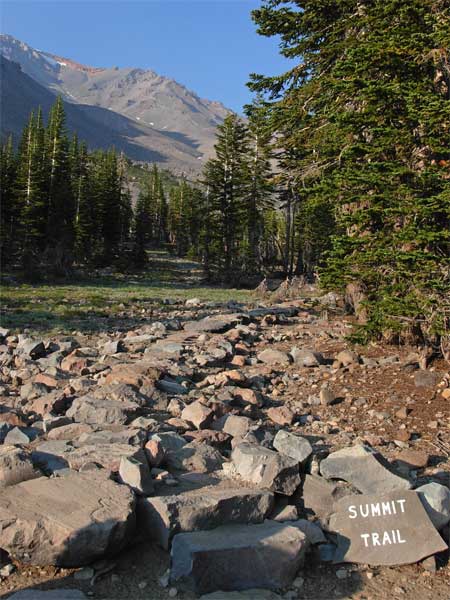
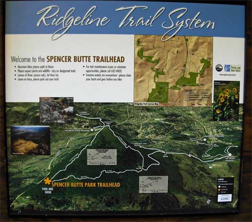
nice hike to the top of Spencer Butte.
They have added new signs and a map, so
I hiked up the presumed standard trail. A steeper trail to the
north (left) was my route my first time, but I thought I'd see
what they have done.
I love the stately forest to hike through,
very much the Pacific Northwest coniferous woods. There were other
hikers and some flowers. The signs warned of poison oak, although
I missed seeing the profuse display that I saw on my first time
back in May 2006. In about 35 minutes, I topped out, with a myriad
of use trails near the summit. I shot my photos
and moved to the rocks more to the northeast. They had a better
view of downtown Eugene. I shot up some film, too, wanting to
use up a few rolls of Kodachrome, special for my older Nikons.
 I
had figured that I might be back, although with other hikers also
wishing to see this beautiful place. I then headed back the same
way down.
I
had figured that I might be back, although with other hikers also
wishing to see this beautiful place. I then headed back the same
way down.
Motoring back to the Interstate, I zoomed
northward. I hoped for a nice dinner in Portland, but I am lacking
of knowledge of any great eateries. I also wished to hike more
in the downtown area, but I had to get some good sleep.
Into the State of Washington, I took a
freeway exit to the side road to Rainbow Falls State Park. I knew
it wasn't much, by other pictures on the Internet, but figured
to check it out. The roads are signed, but with a few turns, and
there is some gravel. I parked, and looked at the park map. The
falls is only a small, 5 foot drop along the Willapa River, but
it is a nice swimming hole for locals, I'd guess. Trying to avoid
capturing swimmers in the scene, I snapped photos of the falls.
I sought to get another angle, but miscalculated
where I could access the other side of the river. I motored back
to the Interstate, and got my reserved motel room in Centralia,
WA. Getting a big bowl of soup, I managed to get to sleep past
midnight.
Up at the earliest that I have been, recently,
I got my diet soda, then noted the low overcast. I took Highway
12 west, and was dismayed at the fog or low clouds. Would my expected,
forecast, sun be spoiled with no good photo ops? I passed through
Aberdeen, WA, and figured that this might be a photographic disaster.
Not much use climbing any peaks with no view.
Miraculously, it cleared at the Coast,
and I hit the Peninsula beaches with good morning light. I stopped
at one beach (they are numbered on
the map although few had any signs or good parking ops) and walked
out amidst the driftwood. I didn't stay long, with many sights
to see today. I stopped at another beach, then came to the best
one, Ruby Beach. I spent some time here for pictures
of the sea stacks and ocean, but it was mildly disappointing.
The Washington coast is not so mountainous as the coast in California.
Too bad the better marvel we have in Big Sur, for instance, has
partly burned.
 I
began to think to save time and money and do the Peninsula in
one day instead of two. I would have either found a cheaper motel
in Port Angeles, WA, or camped out. With my poor sleeping, I might
expect a miserable night awake in my car. The room rates that
I found on the Net seemed high. So, I began to rush things along.
I
began to think to save time and money and do the Peninsula in
one day instead of two. I would have either found a cheaper motel
in Port Angeles, WA, or camped out. With my poor sleeping, I might
expect a miserable night awake in my car. The room rates that
I found on the Net seemed high. So, I began to rush things along.
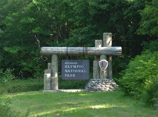
The Hoh Rain Forest was on my must-see
list, and I patiently motored the half-hour, about 20 miles, of
side road to the locale. I paid the $15 park entrance fee, and
began my short hike. There is a shorter
tourist trail that I looped about on. The light with harsh sun
made for my expecting only record shots. There is only so much
software can do, with bright spots and deeper shadow. I looked
at the Hoh River Trail, going to Glacier Meadows, and spoke with
a climber packing out, saying that he had summitted. Mt. Olympus
(7,980'), the highpoint of the park and peninsula, is climbed
from this way.
Having already seen much temperate rainforest
elsewhere, I left after about an hour. I saw I might need some
more gas, too.
Lake Crescent was the main feature on the drive north on U.S.
101, clockwise around the peninsula. I stopped for photos, and
had planned on hiking Pyramid Mountain (3,000') here. I could
skip that. Not so scenic, then, I looked forward to the vistas
from Hurricane Ridge.
There was major road work with delays getting
up there. Gratefully, it was not a crowded weekend. The ranger
had said they weren't getting so many people, I guess due to the
gas prices and economy, and I didn't have to wait too long. Another
peak of sorts awaited. Hurricane Hill (5,757') is a 1.6 mile hike
each way. I got to the main parking lot, packed up my camera gear,
and headed up a likely trail with lots of hikers. Unfortunately,
this led to a Sunrise Point, a tourist trail. The views were good,
though, and I snapped a lot of photos.
I saw my mistake, and figured with the road delays and my shortened
plans, it was better to leave the hill for another time.
Making it back to Port Angeles, I'd rush
along and complete the peninsula loop in good time. Just south
of Quilcene, WA, a drive-up peak, Mt. Walker, rose high for the
car. Well signed, the good 4 mile gravel road leads to two small
parking lots near the top. I had nice vistas
from the north and south sides, and determining the true highpoint,
bagged it.
Back to the U.S. 101 highway, I saw this
southerly part was marked as scenic highway, so I wished to see
it before dark. The Hood Canal, an arm of Puget Sound, made for
the feature to see. So now, I have seen most of it all, another
been there, done that. I can always come back, though I hardly
expect to, now.
Not knowing what I'd be doing, I had not made any more motel reservations.
I found a reasonable room rate in Olympia, WA, although the carpet
was dirty. I slept well enough, though.
 Tuesday,
I was ahead of schedule, so figured to climb Mt. Si, east of Seattle.
This is a popular peak, with a hiker trail to the view, and then
a scramble to the true highpoint. Putting on some 150 miles more
of driving, this fine summit was well worth it.
Tuesday,
I was ahead of schedule, so figured to climb Mt. Si, east of Seattle.
This is a popular peak, with a hiker trail to the view, and then
a scramble to the true highpoint. Putting on some 150 miles more
of driving, this fine summit was well worth it.
I motored northeast on Highway 18, and
came to Interstate 90, then North Bend, WA. Not sure if I'd be
doing this, I had no detailed map or exact directions. Getting
some diet soda at a gas station mini-mart, the counter clerk so
gladly told me where to go.
With such good directions, I quickly found
the trailhead parking lot, then knew I'd have a great day. There
are signs, but it can save much time to know exactly which way
to drive.
With many hikers about, I loaded my big
climbing pack with four liters of water and soda, and started
up the trail. I shot maybe a hundred photos of the pretty
forest trail as I headed up. The trail, with log and rock
steps, and wooden walkways in spots, switchbacks up the steep
hillside for perhaps 3,000 feet. The only mosquitoes that I saw
on this trip (besides maybe Shasta) were here, but as they were
not aggressive, I didn't use repellant. I found no bites later.
Never spotted any ticks, either.
I saw maybe 50 hikers today, many coming
down as I headed up, and vice versa. With a high forecast for
about 76 degrees, I knew it would be better than when I was last
about here, with a high then to be 93 in North Bend.
Speaking with some other hikers, they clambered
up a gray talus pile and said this was it. I inquired about the
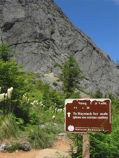
"Haystack," and they said that was further. I got off
the trail, and then found it again. Ahead, the high summit rock
mass looks fearsome, but there is a class 2-3 route up the unseen
right (east) side. I followed use trails and then saw a weathered
caution sign about the scramble.
Heading up the trail, I saw that many hikers
do not do this. I asked hikers coming down if that was the route,
then presumed that it was. For someone who has not done much class
3 recently, like me, it looks intimidating.
I saw another hiker coming back down, who said he didn't like
heights.
 Assuming
that this rocky gully was it, I would give it a game try. My heart
gets sick from considering turning around, as I had figured it
was nothing. I began climbing up the route, with no ducks or marks,
with only a hiker footprint in some dirt. Two more hikers were
descending. It got easier, so I gained some confidence. Then,
I was on the ridge, with views to the west. It looked to be an
airy 25 feet further to a potential highpoint, so I took off my
pack. This part was nothing, but I had left my back-up camera
and drink behind. That was it--the top.
Assuming
that this rocky gully was it, I would give it a game try. My heart
gets sick from considering turning around, as I had figured it
was nothing. I began climbing up the route, with no ducks or marks,
with only a hiker footprint in some dirt. Two more hikers were
descending. It got easier, so I gained some confidence. Then,
I was on the ridge, with views to the west. It looked to be an
airy 25 feet further to a potential highpoint, so I took off my
pack. This part was nothing, but I had left my back-up camera
and drink behind. That was it--the top.
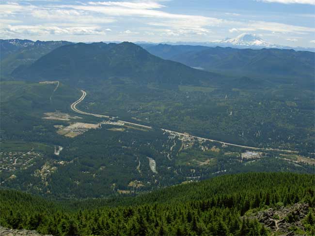
With two other hikers resting there, I
shot the vistas in all directions. Seattle
was clear, and Mt. Rainier lay to the south. Success! The other
hikers left, and I had the top to myself. I shot more photos to
make sure my pictures would be fine--I had a partial memory card
failure just a few weeks before, and many photos then were unreadable.
If I had another similar occurrance, more pictures would be better--some
might make it through.
I left the top, and took my time on the
descent. Another hiker came up by me, and I managed to get down
safely. Routefinding is the best skill needed here, and you can
go a harder way and even fall. Someone once fell and died here,
and I can see how.
Back to the trail and a park bench, I drank
my liquids and rested. I had made it, so good for my self-esteem.
I began to snap more photos of the wildflowers
up here. This was the best floral display for this trip.
Hiking back down the trail went quick,
and my total round trip time was 5:46. I suffered more road work
delay, and then was on my way back to Interstate 5. I had no big
wish to see Seattle again, instead wanting another good peak to
do. I had looked at my maps, and found nothing much, worth the
$55 or more daily lodging expense, that I could do solo. So, I'd
be home the next day.
I got a nice room back in Centralia, WA,
and had a celebration shrimp dinner. I thought of side trips to
Crater Lake, and Mt. McLoughlin 2X, but I'd save my car and money
for another road trip this summer.
My long drive home Wednesday saw a quick,
side trip visit to Jacksonville,
OR, a National Historic District. Feeling good, I arrived
home by early evening.
I hiked only about 16 miles, with 6,000'
gain. I drove 2,100 miles. For my main camera, I used only two
1 GB memory cards, and for my film camera, about a roll of film.
I then shot about 1,400 digital images and movie clips. I spent
about $208 for four nights lodging, and $315 in cash, most for
gas ($220). Buying and using 53.5 gallons, I paid from 4.099 to
4.659/gallon. I didn't eat much.
Using mostly shorts and a T-shirt, I wore
pants and a light second layer while on the coast. My heavier
duty hiking boots could have been replaced by a light pair of
boots. I used my heavy day climbing pack only on Mt. Si, and a
cap proved useful. I perspired a lot, and drank plenty of sodas
and water. The highs in Washington then were mainly in the 70's,
with warmer temperatures further south. I had my air on a lot.
My iPod with battery pack needed no charging, and provided nice
songs while cruising along on the highways. Seems that there are
few radio stations that I like, left along the way.
I ate lightly, with mostly taco snacks
and diet drink, and then a light dinner meal, usually under $10.
I brought along a bottle of diet soda for any camping away from
food and drink, but never camped. The nightly lows were cool,
in the 50's. I never came upon any snow higher up, and would have
done this trip in May if not for the snow report, then. The trails
were mostly dry dirt or dusty, with very little mud or streams
to cross.
It remains to be seen if I beat my sleeping
problems, and do much better for peaks and exercise on my next
road trip. I'll watch the weather, and already have my itinerary
pretty much set. Maybe I should start jogging on a treadmill,
and stop my sometimes anxiety about climbing peaks and doing road
trips, but I deem this an excellent thing when it's all been done.
BACK TO PETE'S
THOUSAND PEAKS HOME PAGE