IDAHO OREGON ROAD TRIP May 4-8,
2008
 Sinning against
the planet by taking a road trip, by many or most enviros, I figured
I'd pay for it with my carbon offset donations. I couldn't wait
to do this, watching the long range weather forecasts for so long.
Gas is now projected to run up to $5 a gallon, so now, again,
was the time.
Sinning against
the planet by taking a road trip, by many or most enviros, I figured
I'd pay for it with my carbon offset donations. I couldn't wait
to do this, watching the long range weather forecasts for so long.
Gas is now projected to run up to $5 a gallon, so now, again,
was the time.
I left home Sunday morning, and motored
eastbound on Interstate 80. The snow was melting fast in the Sierra, and soon we can be
hiking the peaks.
Stopping in Truckee,
CA, for a break, I saw that most was about the same as a month
ago. In Reno, NV, I made some small purchases at the Patagonia
Outlet, beforehand hiking the bump
that I name after the nearby clothing shop.
Declining any breakfast at the casinos,
I motored on east. Clouds, then later, slight rain, made for some
interest passing through Lovelock and Winnemucca, then coming
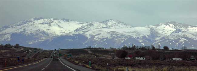
to Elko, Nevada. Plenty of snow graced the Ruby
Mountains and the East Humboldts (photo above). I made it
to Wells, NV, where lodging
was a bit cheaper.
 I
had a first breakfast for dinner at a truck stop casino, then
retired to my room. Having reservations made for each night, I
was on an ambitious schedule that I was hard-pressed to keep.
My total lodging expense was to come to about $191 for four nights.
I
had a first breakfast for dinner at a truck stop casino, then
retired to my room. Having reservations made for each night, I
was on an ambitious schedule that I was hard-pressed to keep.
My total lodging expense was to come to about $191 for four nights.
Up at a good hour, Monday, I took U.S.
93 northbound. Getting to Twin Falls, ID, I wondered what to do.
I stopped for some photos of the Snake
River bridge, and then figured to visit Minidoka Internment
National Monument. This historic site was slated to get some money
to build a guard tower, to commemorate the internment of mostly,
American citizens of Japanese ancestry, during World War II. I
may have a family connection to this, but I wouldn't know, now.
I found the site by
my road maps, in the middle of Idaho farm country.
After a short stay, it was backtracking over the Snake River Canyon
by another bridge,
then through Twin Falls, where I got more drink and rest.
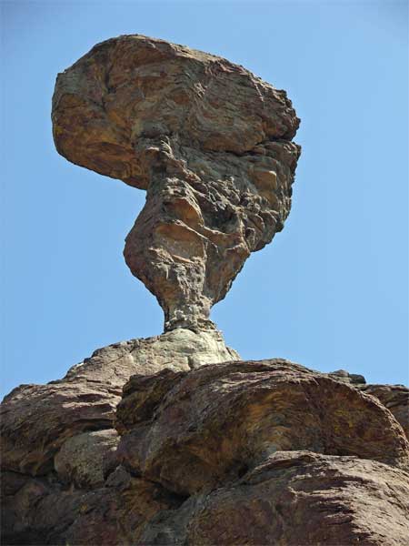
Off U.S. 93, back south of town, I headed
along a signed road to Balanced Rock, another scenic feature that
I had seen on my maps. This was a bit of a surprise, with a trail
to hike to near the feature. I enjoyed the slight uphill workout,
then motored about on side roads to my next destination, Hagerman
Fossil Beds National Monument.
I took a side road to find some fossils,
but all I got was a nice
view. There was a display at the NPS
Hagerman Visitor Center on the relocation camp, and I spoke
at length with the attendant. This makes the fourth camp site
that I had visited now, and I have a few more to go, to see the
Western ones.
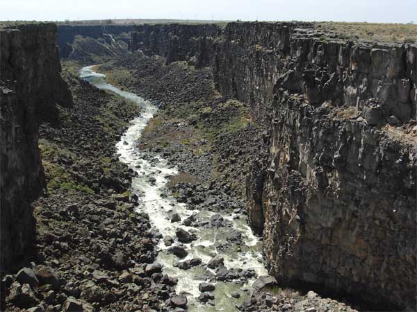
Then, I came to Malad Gorge State Park.
A short road has stops for each of a few vista
points. Pressed for time, this place closes at 4 p.m. I took
pictures expediently (third photo down), and soon was westbound
on Interstate 84.
I got cheaper gas near Boise, ID, at 3.579
a gallon, versus the 4.299 that I paid back in Nevada. Then I
came to Ontario, OR, where I had another breakfast for dinner,
and cheaper lodging, again. I snapped panorama sequences of the
cloudy sunset, impressed
by the Oregon skies.
Tuesday, I had a long day ahead. I motored
north on U.S. 95, headed for Hells Canyon National Recreation
Area. Taking ID 71, I shortly came to the downhill road to the
bottom of the Snake River canyon. A scenic road heads north and
downstream, along a couple dams and reservoirs.
The scenery
gets better as you head along. I spotted a couple mountain goats,
and made several stops for the pictures. The canyon gets narrower
and steeper, and I began to start liking this. I came to the end
of the road at a closed contact center, and marveled at the Gorge.
With no time now to go on the trail that runs further, maybe I'll
come back, someday, and hike this incredibly rugged, wild part
of this gorge.
 I
went back to the junction with Oregon Highway 86, and changed
my clocks. Back to Pacific Time, I found that my cameras had reset
themselves somehow. This may have happened once or twice before.
I
went back to the junction with Oregon Highway 86, and changed
my clocks. Back to Pacific Time, I found that my cameras had reset
themselves somehow. This may have happened once or twice before.
The road west follows the Powder
River, where a highway point of interest shows the slide that
blocks the river.
Soon, after a distant
vista, I came to Baker City, OR, and Interstate 84, again.
I stopped for pictures of the Geiser
Hotel again, then took OR 7 west to U.S. 26.
I thought that I had plenty of time to
get to Bend, OR, where I'd hike Pilot Butte (4,138') for my 4X.
Nope. I shot a few pictures of Picture
Gorge near the John Day Fossil Beds National Monument, which
I had thought I'd visit. I had to move right along. Receiving
some slight drizzle, I stopped at a nice, official, overlook
of Prineville, Oregon. No snowy peaks or rainbows, but I decided
to skip Pilot Butte in Bend.
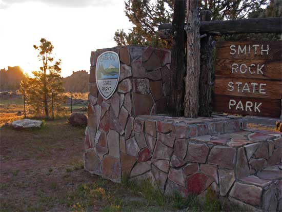
I headed then for Smith
Rock State Park, where I hoped for a good sunset. The light
hit the crags, and I spent time working on my own picture. The
sky never lighted up well, so I shortly left as the sun went behind
some clouds.
Taking U.S. 97 south, I got lost in Bend.
Remembering a main street that my motel was located on, I came
to a traffic circle, and motored ahead in the dark through new
development. This town has really grown! I envied the people that
can live here, and despite the late hour, witnessed the various
upscale neighborhoods and facilities.
Finally finding my motel, I checked in,
and then went out for late night food. I usually had no morning
breakfasts except for diet soda, then a sandwich or snack in the
midday. I kept dinners light, and will probably lose some weight
on this short trip. That halts some carbon emissions, there, due
to savings of the fuel spent to produce and deliver food.
 Wednesday,
I awoke later, and had my morning caffeinated drink. It was north,
then, through Sisters, OR, and I had a highway
view of the Three Sisters. I was told that the South Sister
could be climbed without ropes, and no crevasses to avoid. Someday,
maybe.
Wednesday,
I awoke later, and had my morning caffeinated drink. It was north,
then, through Sisters, OR, and I had a highway
view of the Three Sisters. I was told that the South Sister
could be climbed without ropes, and no crevasses to avoid. Someday,
maybe.
Motoring west on U.S. 20, I went over Santiam
Pass. Snow covered the Cascades, here, and clouds obscured any
peaks. The ranger station attendant said this was the wettest
year for the last 40 years, but I thought that probably wasn't
true. I'd like to come back here and utilize the Sno-Park areas
for some short ski tours.
Some waterfall hikes couldn't be accessed
due to the snow. The tall trees of this forest impressed me as
usual, and I turned left on OR 126 to Eugene, OR.
I had to get back to California this night.
I rushed along and came to the Oregon Coast near Florence, OR.
It was cloudy with a 20% chance of rain. I passed through Coos
Bay, OR, without a stop, and found the road to Allegany, the way
to the waterfalls hike I planned for some time to do.
The road into the Golden and Silver Falls
State Park was narrow and somewhat hazardous. The road edge drops
off with no shoulder, and a bad drift over the edge would be terrible.
The trees get nice, though, and I shot many photos of the temperate
rain forest. The last four miles get potholed and rough, but I
persevered and made it to the trailhead.
There is only a very short hike to each of the falls,
which ran nicely. Managing some movie clips (12.4 MB, 0:40), I didn't take too long, with a long way to go
tonight. I used all of my cameras to get some nice photos, then
motored back to U.S. 101.
The sun poked out, and I enjoyed many more
photo stops of the ocean
vista, and the rugged coastline. I thought of having a nice seafood
dinner, but I didn't know where was good, and also didn't want
to get to my motel too late. I filled up with gas at 3.799 in
Brookings, OR, and then crossed into California. I watched the
sunset at a Crescent
City coastal access point, then motored into the night along winding
highway with thick ancient forests.
My last day, Thursday, I left Eureka, CA,
and enjoyed the views ahead on the Redwood Highway. I took Highway
1 south at Leggett, CA, and motored tediously on winding mountain
road, with no views of note. Finally coming to the California
Coast, I began my first stops for pictures. I don't ever recall
being on this part of the coast, so I made sure to get photographs.
I hiked a bit at the no fee Mackerricher State Park, with sealife in tide pools and
crashing waves.
I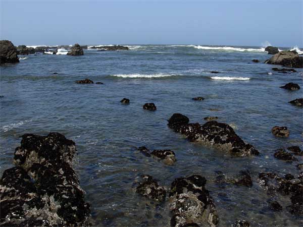 nto
Fort Bragg, CA, for drink and food, I looked at my maps. I had
already seen the coast south of here, and had no big desire to
revisit Mendocino, Santa Rosa, or Petaluma, CA. So, I took CA
20 to Willits, and U.S. 101. I'd be home early tonight.
nto
Fort Bragg, CA, for drink and food, I looked at my maps. I had
already seen the coast south of here, and had no big desire to
revisit Mendocino, Santa Rosa, or Petaluma, CA. So, I took CA
20 to Willits, and U.S. 101. I'd be home early tonight.
Taking CA 20 east, past Clear Lake, CA, I then came to Interstate
5 at Williams, and arrived home by about 7 p.m.
Driving over 2,200 miles, I hiked only
a few miles, mostly on short trails and towns, with very slight
gain. Most of that was had at Cape Sebastian Viewpoint in Oregon.
I used some three 1 GB memory cards with my main camera, with
then about 2,110 total digital images and movie clips. I used
most of a 36-exp. roll of Kodachrome as film back-up, with then
three Nikons used.
Charging $191 for lodging, I spent $335
in cash, with a clothing purchase at $32. That makes then about
$558, total. No souvenirs, postcards, books, memorabilia, or anything
of that sort.
Wearing up to three layers, I wore long
pants although I had seen some tourists in shorts. Comfortable
with a T shirt in my car at times, I kept to one pair of light
boots, and never used my spare clothes. My duckbill logo cap covered
my raggedy long hair, and I used two pairs of gloves for driving.
I found a tick in my car, and there were hungry mosquitoes, in
places. I noted deer, squirrels, many birds, and the two mountain
goats.
The weather had been fine, except for the
photography. I had mostly white skies. I never got any rain while
walking or hiking, and enough sun came out at the right times,
luckily for me. Glad to have no accidents or serious car problems,
I am always worried about loss, or theft of my gear, but that
has been, in hindsight, a paranoid notion.
Using both heating and a/c for my car,
it began to show its age, with my dashboard lights going out,
and a sensor showing a problem with my airbag, both glitches clearing
out after a restart of my car. I feared for my headlights going
out, once, and kept looking at my tires and gauges.
Using 55 gallons of gas, that all cost
about $200. My mpg had gone up a slight bit from previous road
trips, and I began to wonder why we all aren't going to hydrogen
fuel, by now. The technology has been around for some time, but,
I'd guess, who would invest in costly solar or wind powered fueling
stations when no one drives such a vehicle, yet? Here's the start
of a Google search ("solar wind powered hydrogen fueling
stations") to find more information on this, at your own
risk, of course, here.
I will need to drive another 2,000 miles
in three more weeks to make good use of my car, so I'm looking
at Washington State. With no partners, trips to the local Sierra
seem to be out. I wish to see new things, anyway, and keep myself
pleased. Financing is less of a concern. Soon, summer will come,
and it'll be smarter to escape the heat. I climbed no peaks on
this particular May 2008 road trip, and will want to make up for
that.
BACK TO PETE'S
THOUSAND PEAKS HOME PAGE