NORTHWESTERN CALIFORNIA PEAKS
AND HIKES LOOP: Whiskeytown Falls, Chemise Mountain (2,598'),
Lower Devils Peak Lookout (5,081'), and Black Butte (6,325') 2X
April 25-28, 2007
 Seeking to do another short road trip, I decided
that less driving was better. Rather than zoom out to Western
Idaho (currently then, forecast adverse weather, anyway), or elsewhere,
I opted to do another check of this fine, fairly local, area,
to do some hiking and photography.
Seeking to do another short road trip, I decided
that less driving was better. Rather than zoom out to Western
Idaho (currently then, forecast adverse weather, anyway), or elsewhere,
I opted to do another check of this fine, fairly local, area,
to do some hiking and photography.
Up all night without sleeping, I took off
at about 3 a.m., Wednesday, to head north on Interstate 5. It
is nicer with less traffic. I filled up with gas at 3.169, and
hoped that my car did O.K.
Getting some breakfast enroute, I came
to Redding, CA, and made another visit to the famous Sundial Bridge.
I got there in time to view the sunrise,
with reflections off the mighty Sacramento River.
Getting drowsy, I had some coffee, got
more gas at 3.429, and then drove west on Highway U.S. 299. Coming
to the visitor center for Whiskeytown Shasta-Trinity National
Recreation Area, I looked at the map to find the directions to
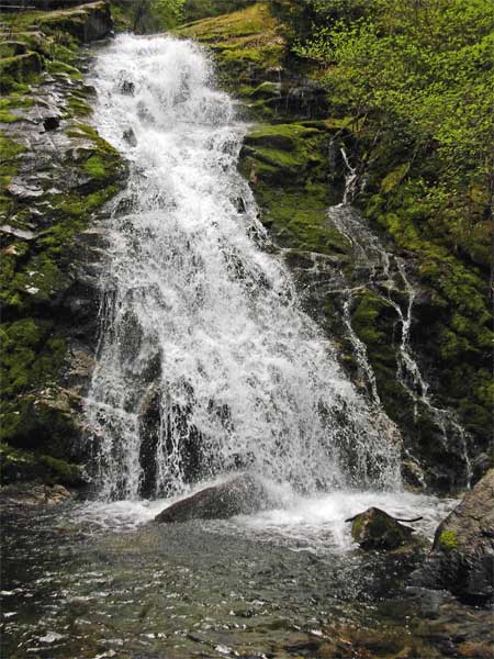
the newly "discovered" falls. The NPS built a new, 1.7
mile (each way), trail to this worthy sight, and I quickly discerned
the way there.
The Whiskeytown Falls trailhead has an
outhouse, and signs. It took me 40 minutes of hiking to get to
the falls destination. A few hikers were already there, but took
off as I got there. So, I had the falls to myself. I began to
shoot photos and movie clips (640 x 480 pixels, 10.7 MB, 0:18), without being disturbed by tourists
wanting me to snap their pictures, or to get in the way.
I had seen many images of these falls on
the Net, and hoped to do better with my newer camera. It did well.
There was high overcast, so the light was low, but fine for me.
I snapped several pictures of the lower part of the falls (top),
then clambered up the wet, rock stairs to view the upper
falls.
Finished with my photography there, I headed
back to U.S. 299, and drove westward. I chose to see some new
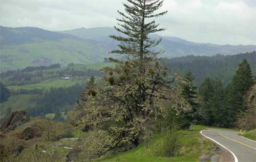
country, for me, so headed south on CA 3. Passing through Hayfork,
CA, I noted the rural scenery. Taking then CA 36 west, I tried
a paved, side road, by South Fork Mountain Summit (4,077'), which
I apparently had mistaken for a vista point. Stopped by snow in
a few miles, I turned around and went back to the major highway.
The Lassics are seen from here.
 CA
36 follows and crosses over a couple river systems, as the Mad
and the Van Duzen Rivers. I did obtain some new sights. This sometimes
narrow road doesn't have any center line, for a good part of it.
I wanted to get to Eureka, CA, in due time, so didn't stop much
for pictures.
CA
36 follows and crosses over a couple river systems, as the Mad
and the Van Duzen Rivers. I did obtain some new sights. This sometimes
narrow road doesn't have any center line, for a good part of it.
I wanted to get to Eureka, CA, in due time, so didn't stop much
for pictures.
Finally coming to Fortuna, CA, the first
major town I came to along U.S. 101, I stopped for a snack, drink,
and a walk. Heading north, I got a room in Eureka, and enjoyed
resting up a bit.
Then, it was to the old part of town. I
strolled about, snapping more photos
of the buildings, and then dined at a local restaurant. Good food!
It was magic hour, but with only some neon, I had little new to
shoot.
Thursday was to be a big day. With drifting,
low, morning clouds, I motored along south on U.S.101, the Redwood
Highway. I had seen the Avenue of the Giants twice before, so
declined to take that scenic byway, again. I shortly came to Redway,
CA, and took the Shelter Cove Road west to the coast.
Chatting with a BLM visitor center attendant,
I saw that my main goal, King Peak (4,087'), entailed some rough
roads. They recommend high clearance vehicles. It is a long, dirt
road, drive to the King Peak Trailhead, by the King Peak Road,
and I was low on gas. So, I decided to do an easy, alternate peak,
Chemise Mountain.
Arriving to the Nadelos campground and
presumed trailhead, I was a bit confused by the signs. It reads
that parking in a camp spot requires paying a camping fee, but
that seemed to be day use parking, too. I left my NPS pass with
hologram on my dash, and hoped for the best.
 Starting
up the trail, I passed many hundred foot high madrones, and noted
three wooden benches for resting on the way up. The trail ascends
through forest, and it stayed cool. The junctions were well signed,
and I took the short side trail to the summit.
Starting
up the trail, I passed many hundred foot high madrones, and noted
three wooden benches for resting on the way up. The trail ascends
through forest, and it stayed cool. The junctions were well signed,
and I took the short side trail to the summit.
The Chemise Mountain summit views are all
to the east, with rolling, forested ridges. I had read that the
view was good, but the attendant did say that the Chinquapin Trail
was worthwhile. I went back to the main Lost Coast Trail, and
ambled southward, a few minutes down, to get a view of distant
Shelter Cove. Further along, there is a better view of the Pacific
Ocean, also over the brush and through the trees.
Capturing these views, I shortly headed
back up to the peak, and then down the same trail. Worried about
mountain lions, I noted some fresh scat, probably bear, on the
trail. My bulky climbing pack serves to make me look bigger, if
that might help. I can swing it perhaps as a defensive weapon,
against a smaller cat.
Relieved to return to my car without either
a ticket or an attack, I clocked my total round trip time as 2:15.
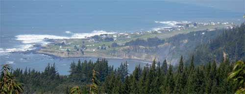
With plenty of afternoon left, I motored down to the coast.
 Black Sands Beach is now much
different than I remembered in 1980, during my 25 mile, Lost Coast
backpack lead. Shelter Cove has been more developed, too. No motorized
vehicles are now allowed on the beach. A sign at the BLM visitor
center stated that something like 2,500 people hiked the coast
in 2006. We had it lucky, then in 1980, as no $90 organized group
fees were charged, and, even on a holiday weekend, we had seen
no other backpack groups!
Black Sands Beach is now much
different than I remembered in 1980, during my 25 mile, Lost Coast
backpack lead. Shelter Cove has been more developed, too. No motorized
vehicles are now allowed on the beach. A sign at the BLM visitor
center stated that something like 2,500 people hiked the coast
in 2006. We had it lucky, then in 1980, as no $90 organized group
fees were charged, and, even on a holiday weekend, we had seen
no other backpack groups!
Shooting movie clips of the waves crashing
onto the shore, I took my time, here. A good wildflower bloom
was ongoing. I can hardly imagine that we had done this, so well!
They didn't require food canisters, then, and we never had any
high tides to stop us.
Motoring back up the hill, I made a trail
report at the visitor center. They said it wasn't the tourist
season, yet.
I thought about doing King Peak, but figured
it wasn't worth risking my car. I may someday plan to hike the
4-6 mile, approach, side road to the trailhead, then another 2.5
miles to the peak. I bought a map, and saw there are other peaks
to climb, here. Plenty of trails, too.
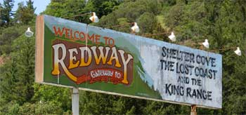 Enjoying
a short photo stop with drink back in Redway, I shortly was headed
back north on U.S. 101. I had some data on visiting the Headwaters
Forest Preserve, and found the road to the south trailhead. The
road was gated, with a sign stating, "guided hikes only."
So, it was onwards and northwards!
Enjoying
a short photo stop with drink back in Redway, I shortly was headed
back north on U.S. 101. I had some data on visiting the Headwaters
Forest Preserve, and found the road to the south trailhead. The
road was gated, with a sign stating, "guided hikes only."
So, it was onwards and northwards!
Nearby Ferndale, CA, is noted for its many
Victorian buildings. That was worth a gander,
by me. I parked my car, and walked along the streets. The sun
was sometimes behind clouds, and the feeling for me was magical.
I captured many images, and then left without spending a cent.
Back to Eureka, I had a late dinner, and
retired again to my motel.
Friday would be my biggest day for this
trip. Motoring back east on U.S. 299, I took the Klamath
River Highway, CA 96, north, then east. Floating mists made
for some drama. It was early in the day, but I had a bigger hike
to do. Passing through Willow Creek, Hoopa, Weitchpec, Orleans,
and Somes Bar, I stopped in Happy Camp, CA. Speaking to the USFS
attendants, I secured information on how to find the Pacific Crest
Trail trailhead. I bought some cold drink at the local market,
and soon was miles along on CA 96, looking for the PCT signs.
The trailhead comes up fast. I had to turn
around, and go back to it. No other cars there.
I gathered together what I'd need for this
longer pull, uphill. The warnings about recent mountain lion sightings
had me taking my ice ax. I had been assured of snow, too, but
there was to be absolutely none, here.
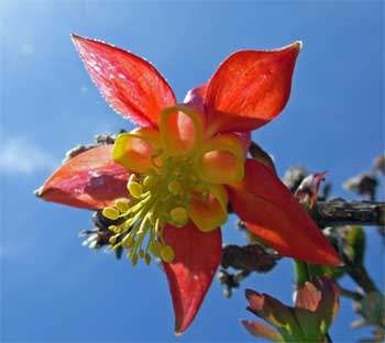
The trail climbs in switchbacks at first,
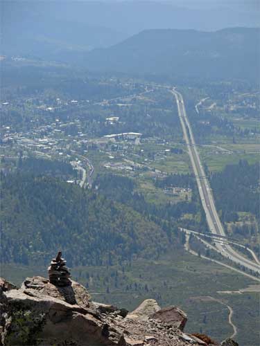
and there was a nice wildflower display. Passing a spring, I signed
in the trail register, there. The Seiad Valley below made for
a nice view. I stopped briefly for many close-up photos, then
hopped over or under some four fallen trees. I then caught sight
of my hike goal, Lower Devils Peak Lookout. I had used some two
hours to get to see it. Still distant, it was doable.
 Another
high spring is passed, and then I was to the ridge.
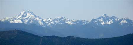
Nice views of other snow bound peaks presented themselves. I hoped
for a view of the Marbles, but only the Siskiyous (right) were
to be seen. Mt. Shasta loomed over a ridge.
Another
high spring is passed, and then I was to the ridge.
Nice views of other snow bound peaks presented themselves. I hoped
for a view of the Marbles, but only the Siskiyous (right) were
to be seen. Mt. Shasta loomed over a ridge.
Then, I topped out after four hours from
the car. It was cool enough to be nice, but I stripped off most
of my upper layers. The sights were so worthwhile! I was glad
that I hadn't turned back! This is more a bump on a ridge, so
I wouldn't count it as a peak, despite the name. Not enough vertical
drop in the separation between this and Middle Devils Peak!
After drinking most of my water, I snapped
more pictures, then headed down. I could relax, once I lost my
fear of any big cat attacks. And now, this was so beautiful a
day!
Back to the highway in 2:23 from the top,
I continued along eastward on CA 96, and noted the drier mountains,
once past the western portions. I took CA 236 to Yreka, CA, where
I had a reservation.
Doing another quick magic hour walk, I
saw that the historic part of Yreka is fairly small. I chose a
restaurant here to have a sumptuous meal, and again retired to
a motel room.
Saturday, I was up at a decent hour. After
a quick breakfast, I zoomed south on Interstate 5, and walked
about the town of Mt. Shasta City. I had another small breakfast,
then was on my way to the Black Butte trailhead. From the Everett
Memorial Highway, one takes the signed forest road 41N18.
Beginning my peak hike, yes, I do count
this small one. It does have nearly 1,900 feet of gain. The trail
leads to the top, with many views of Mt. Shasta. It was more scenic
than I recalled. I snapped lots of photos, then after a 10 foot,
class 3 downclimb (a class 2 knife-edge is optional), I topped
the concrete square. My time to here was 1:44.
 I
had left a register back 24 years ago, but there was no hope that
it'd still be there, with as many hikers that must do this. This
is a fine, easy, peak for those unable or unwilling to do Shasta.
I once again snapped many photos of Mt.
Shasta, and stayed here longer. Nothing to do but get back
home, to near or about 90 degree highs.
I
had left a register back 24 years ago, but there was no hope that
it'd still be there, with as many hikers that must do this. This
is a fine, easy, peak for those unable or unwilling to do Shasta.
I once again snapped many photos of Mt.
Shasta, and stayed here longer. Nothing to do but get back
home, to near or about 90 degree highs.
Leaving the top at Noon, I was back to
the trailhead at 1:10 p.m. Two more hikers, then a family, were
headed up.
Getting cold drink back in town, I zoomed
south on I-5 and watched my fuel consumption. I had almost no
cash left. My calculations were right, and I got enough gas to
get me home.
I had hiked about 25 miles, and about 3
additional miles walking about towns, with 7,300' gain, total.
I drove well over a thousand miles, using some 29 gallons of regular
(paying 3.559/gal., about Eureka, set another record high for
me). I spent under 300 dollars, total. Capturing some 1,900 images
and movie clips, my cameras did fine.
I saw no ticks, or aggressive mosquitoes,
on the hikes. There were deer, chipmunks, snakes, lizards, and
birds. At most, only a few clouds obscured any view. The forecast
chance of rain over this time period was 10%. I had known, then,
that it would be good.
Much of the time, I had on four light layers.
It wasn't really cold, but my clothing was all breathable, making
my comfort highly accommodated. I had old sleeping bags along,
just in case I was to camp, or make this a longer trip without
more lodging expenses.
Next in my sights are maybe a peaks carpool
for the May holiday weekend, should I get a partner, or perhaps
Western Idaho, and in summer, Montana!
BACK TO PETE'S
THOUSAND PEAKS HOME PAGE