2007 Winter Arizona Peaks and
More: Ryan
Mountain (5,461') 5X, Camelback Mountain (2,704'), Piestewa Peak
(2,608'), "A" Mountain or Sentinel Peak (2,887'), Tumamoc
Hill (3,108'), Sugarloaf Mountain (7,310') 2X, Heliograph Peak
(10,022'), Thomas Point Trail
February 25 to March 4, 2007
 With rain forecast locally for the next four days,
and good weather down south, it was an easy choice to get going
on my Desert Winter 2007 road trip. I had hoped to go over the
Christmas holidays, but lethargy and lack of a partner decided
that, then. Having to pack up and make arrangements the day before,
I had to leave without much cash. Planning to be pretty frugal,
I would use plastic for the motels, and for maybe some finer dining.
With rain forecast locally for the next four days,
and good weather down south, it was an easy choice to get going
on my Desert Winter 2007 road trip. I had hoped to go over the
Christmas holidays, but lethargy and lack of a partner decided
that, then. Having to pack up and make arrangements the day before,
I had to leave without much cash. Planning to be pretty frugal,
I would use plastic for the motels, and for maybe some finer dining.
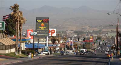
Taking off Sunday morning at 7:20 a.m.,
I headed south on Interstate 5. I had wondered about making it
to Phoenix or Tucson in a long, one day, push, but settled on
driving to Barstow, CA. Not having done much recently, I thought
to take it easy on my first day. Walking about Barstow's Main
Street, old Route 66 (photo top left), for some exercise, I endured
the high winds, up to 47 mph gusts.
Monday, I headed south on CA 247 and then
to Joshua Tree National Park. I easily hiked Ryan Mountain for
my 5x, and enjoyed the clear views of the high Southern California
peaks. I made some photo stops, as the Cholla Gardens, and then
the General Patton Museum. Upon getting again onto Interstate
10, I sped eastward to Phoenix, AZ. The Kofa Mountains, Eagletail
Mountains, and the small, freeway exit, businesses made for some
interest.
Securing a motel room in Phoenix quickly,
I motored about in the night to see the town. Someday I'll do
an urban hike. Dining out, I enjoyed a nice meal with plenty of
fresh, stir fried vegetables.
 So,
Tuesday morning, I motored through town with busy, rush hour,
traffic to my first new peak for this trip. Camelback Mountain
is the highest of the Phoenix urban park peaks, so it was my first
choice. This is a highly popular trail from Echo Canyon, the standard
way up. Many other hikers, lots with music players, had taken
off up the trail. It was wiser to pick a day midweek, since this
trail is said to have hundreds of users on weekends. I was thus
able to get a parking spot right away.
So,
Tuesday morning, I motored through town with busy, rush hour,
traffic to my first new peak for this trip. Camelback Mountain
is the highest of the Phoenix urban park peaks, so it was my first
choice. This is a highly popular trail from Echo Canyon, the standard
way up. Many other hikers, lots with music players, had taken
off up the trail. It was wiser to pick a day midweek, since this
trail is said to have hundreds of users on weekends. I was thus
able to get a parking spot right away.
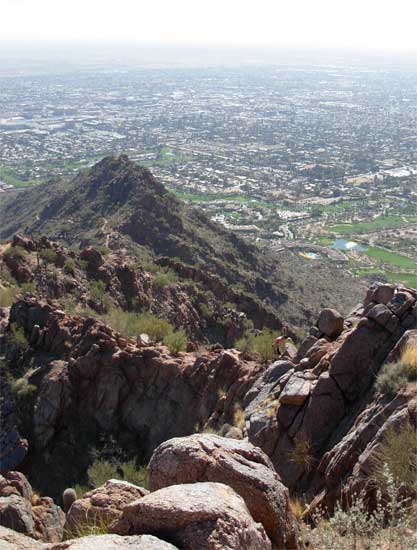
With handrails and steps, I quickly ascended
to the top, stripping off a layer or three as it warmed up. The
urban vistas were awesome. I snapped
many photos of the distant highrises as I hiked up, and marveled
at the size of this desert metropolis. Gaining a view (photo right)
of the more challenging route from the south, I will have to wait
to try that someday, perhaps.
Back to the car, I motored over to the
next peak. Piestewa Peak is named after a Hopi soldier who lost
her life during the Iraq War. I was never to see any signs or
other references indicating the name change, and locals referred
to the peak with the older name.
Starting up at 12:10 p.m., I took the steep
trail to the summit. Many hikers used this trail, too. I viewed
the sight of Camelback Mountain to
the south, and it made a dramatic appearance.
Many hikers apparently do not climb the
easy class 2 rocks to the true summit, which I easily did. My
time was about an hour to the top, as with the previous peak.
A few joined me. Enjoying the beautiful day, I shortly left the
summit and headed back down.
I wished to drive to Tucson, where lodging
was a bit cheaper. There was a nice sunset
as I motored southeast along Interstate 10. I had had a few traffic
slowdowns, and then, coming into the town, I again quickly secured
a motel room. This now seemed so much nicer than looking for a
spot in a nearly full campground, or for a desolate campspot.
I motored about town at night here too, looking for a place to
eat. Wanting to pursue more culinary interests, I got some Chinese
food and dined well, then.
Now, Wednesday, I woke up and drove to
the Sentinel Peak Park for my easy hike to the first of two smaller
hills. The gate was closed; it was 5 minutes early. Nobody around.
So, I went back for breakfast to wake up more with diet soda and
fast food, and wait for the park to open. Back to the park after
a half hour, workers let me in. There are two gates, each with
different times to open. I drove up to a magnificent morning
vista of Tucson. I shot many photos, and later, a roadrunner
posed nicely for a photo. It is a short use trail to the top of
"A" Mountain, passing by the red, white, and blue "A."
The top was rent with litter and graffiti, unfortunately.
 Finished
with the photo hike, I motored back down the paved road to the
lower parking lot for the second hike. Taking the signed Sentinel
Ridge Trail, I crossed a downed barbed wire fence and took the
use trail toward Tumamoc Hill summit. Surveyors on top told me
that hikers weren't supposed to be up there, although two women
hikers had directed me to the top, saying nothing about that.
They left me alone enough to get my photos from the top, and one
of these University of Arizona people told me about some petroglyphs
nearby. I found some, and snapped photos.
Finished
with the photo hike, I motored back down the paved road to the
lower parking lot for the second hike. Taking the signed Sentinel
Ridge Trail, I crossed a downed barbed wire fence and took the
use trail toward Tumamoc Hill summit. Surveyors on top told me
that hikers weren't supposed to be up there, although two women
hikers had directed me to the top, saying nothing about that.
They left me alone enough to get my photos from the top, and one
of these University of Arizona people told me about some petroglyphs
nearby. I found some, and snapped photos.
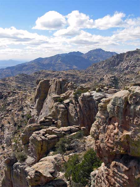
Back to the car, I motored east along Speedway
Boulevard to look at the Catalina Highway. Hoping to drive-up
Mount Lemmon (9,157'), I was to enjoy the scenery instead. The
road to the top was closed, by snow. Coming to the ski area, the
summit road was gated there. No resort skiing, too, although there
seemed to be plenty of snow. I stopped back at a lower scenic
view point to take more photos (left).
You need to pay for a permit to park along
the highway, or have and use a Golden Eagle Pass, as I did. There
is a wilderness area to the west. Many cyclists used this highway,
and I'd imagine it is a nice downhill cruise back to town.
Then, for me, it was south through town
to get back to the Interstate. Quite busy traffic.
Next