STEVENS TRAIL 18X April 29, 2006
 Having to cancel a trip with a new, potential partner,
I decided to do a hike, anyway, this Saturday. The Stevens Trail
is a favorite of mine, but it has lots of poison oak. The sensitive
and allergic can come into frequent and close contact, with the
nasty little shrub growing on both sides of the narrow footpath.
Having heard so many horror stories about unaware hikers getting
rashes or severe reactions, it was better to let that day go.
Having to cancel a trip with a new, potential partner,
I decided to do a hike, anyway, this Saturday. The Stevens Trail
is a favorite of mine, but it has lots of poison oak. The sensitive
and allergic can come into frequent and close contact, with the
nasty little shrub growing on both sides of the narrow footpath.
Having heard so many horror stories about unaware hikers getting
rashes or severe reactions, it was better to let that day go.
To be a bit cooler, this weekend, I motored eastbound along Interstate
80. Arriving at the well signed, BLM trailhead, I was able to
secure a parking spot, quickly. Most hikers will want to start
their hike in the cooler morning, although then they come out
at a warm part of the day. I began my hike at 1:45 p.m. It wasn't
too warm, but the hike starts downhill into the North Fork
of the American River Canyon.
Passing many hikers coming out, I made
good time. I enjoyed doing my photography, and the trail was a
wildflower garden. I've seen it with more poppies, but many other
species grew in the greenery along the trail. I shortly stripped
down to a single layer, and stopped for pictures as I saw them.
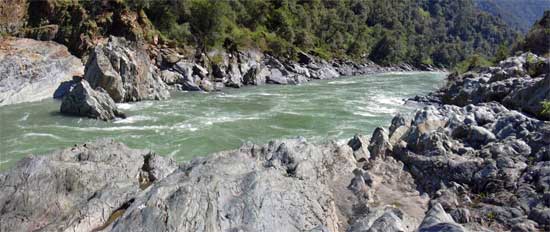
The river was quite the sight. Usually the North Fork is more
serene, in winter. However, the spring runoff is impressive, and
worth seeing, here.
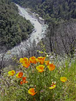
I snapped photos of a clump of poppies
with the North Fork below in the distance. Not the perfect shot,
but it will have to do. I kept notes on my time, and came to the
only muddy spot on this trail, today, just before the use trail
down to the river rocks. Continuing for now, I quickly came to
the end of the trail. The side creek was high, and I declined
to jump it. Other hikers got across, but I turned back. Not much
to see, further along.
Taking the side trail down to my favorite
rocks along the river, I snapped a few photos of their polished
nature. The sun glinted off them harshly, and I tried several
angles. I took movie clips of the rapid waters, and did pans of
the flowing river. I spent till 4 p.m., here, then started out.
The winds had come up, making it cooler. I suppose the delta breeze
kicks up the mountain breezes, and I sure felt fine. A single
tracker pedaled down the trail, then passed me going back up.
A few other hikers were coming down in the later part of the day.
I shot a few more photos as I saw them, with the light still pretty
harsh. Thunderheads were building up elsewhere over the Sierra,
and I had glimpsed them as I looked up canyon.
 I
was shortly back to the familiar landmarks, and took my time.
The hike was now in shade, and was pleasant enough. I came out
to the parking lot by 5:40 p.m. Most cars were gone. I stopped
at a fast food place for drink and slight food, then whizzed back
west on the Interstate.
I
was shortly back to the familiar landmarks, and took my time.
The hike was now in shade, and was pleasant enough. I came out
to the parking lot by 5:40 p.m. Most cars were gone. I stopped
at a fast food place for drink and slight food, then whizzed back
west on the Interstate.
The hike is 9 miles round trip, with about
1,000' gain. I snapped about 141 images and movie clips, using
about $10 worth of gas, now at 3.099. The refresh break cost me
a bit over $2, and there were no other costs. My pants were warm,
and shorts would have been better. My hike strategy should now
be for heat, and I will seek cooler temperatures. Morning, or
higher elevations.
All hikers today were pleasant, moving
aside, or gracious enough to allow for me moving aside, on the
narrow trail. This is not a hike for one to take people not used
to heights. There are what some might call narrow ledges, and
you can fall terribly if you lose your balance or misstep.
There were plenty of flying bugs, but I
noticed only a few mosquitoes, all about the main creek to cross.
They weren't the highly aggressive type. Didn't see any ticks,
at all. The creeks all were running,
and so many wildflowers were blooming. The area is recovering
from the past fire, and soon, aside from the burned, dead, gnarled
oaks, and other trees, all may look about the same. It seems,
now, to be till next late fall, or winter, that I will return
to this trail.
BACK TO PETE'S THOUSAND
PEAKS HOME PAGE