OREGON COAST RANGE PEAKS: MARY'S PEAK (4,097'), SADDLE MOUNTAIN
(3,283'), KINGS MOUNTAIN (3,226'), ELK MOUNTAIN (2,788'), LARCH
MOUNTAIN (4,058'), SPENCER BUTTE (2,065'), MT. PISGAH (1,516'),
MT. BOLIVAR (4,319'), AND UPPER TABLE ROCK (2,036') MAY 11-16, 2006
 This is what I have saved and scrimped for--another
peaks adventure. I e-mailed the land managing agencies for road
openings dates, and conditions. They were slow to answer, if at
all. Seeing an unbelievable long spell of good weather forecast,
I chose to take off Thursday, the 11th.
This is what I have saved and scrimped for--another
peaks adventure. I e-mailed the land managing agencies for road
openings dates, and conditions. They were slow to answer, if at
all. Seeing an unbelievable long spell of good weather forecast,
I chose to take off Thursday, the 11th.
I left home at 8:25 a.m. and motored, with
a traffic jam detour necessitated up CA 113, promptly north on
Interstate 5. Filling my tank at 3.119, I was to stop a few times
this day, for food, drink, and rests. In a few hours, I was at
the USFS ranger station in Mt. Shasta City, checking on that lovely mountain. I had halfway wondered
about bringing along my skis to tour up to Lake Helen, and perhaps
partway up Mt. Hood, but decided against it.
Passing through the various, nicely set,
Southern Oregon towns on the Interstate, with Ashland, Medford,
Grants Pass, and Roseburg, I approached Eugene, OR, in late afternoon.
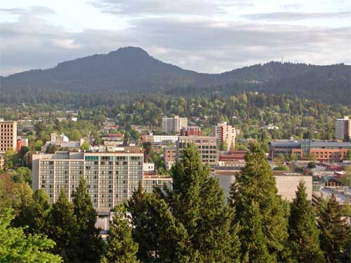
I parked in their trendy downtown
area, and strolled about a bit. Motoring up Skinner Butte,
I enjoyed the late afternoon sun
cast over on the taller buildings, and looked south upon Spencer
Butte, a point I was later to hike.
I obtained reasonable and reliable lodging,
as I was to do each night of this trip. I had made reservations
by the Internet, sparing me an even more, few dollars, for the
low room rates, for three nights in Portland. Retiring to my motel,
then, I thought to try to feast a bit better on the fine dining
available in the Pacific Northwest.
Getting up by about 6 or 6:30 a.m., I was
always up and off. I have my standard drink in the morning, a
diet cola, and usually a breakfast sandwich. Then, I take off
for the day's destination.
This Friday, I headed for Corvallis, OR,
and Mary's Peak. This is the highest point of the northern Oregon
Coast Range, Benton County, and is a near drive-up,
then being an easy start to my little adventure. I took OR 34
west into the hills, and turned north on an all paved approach
road toward the top. I arrived to a huge parking lot, where the
fee station was neglected. There were no envelopes. I hiked the
short dirt road to the top, and the views were hazy through the
clouds. A few other hikers were visiting this summit, today. So
then, back to the Interstate, I headed north.
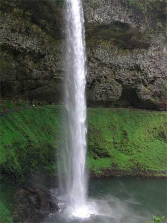 My next destination was OR 22, and Silver Creek
Falls State Park. I motored along on country byways, and shortly
came to this magnificent Oregon State Park. I paid the day use
fee by machine, and hiking down a cobbled stone trail, viewed
the South Falls. It is a 177 foot
high falls, spilling over a deep horizontal cleft in the rock.
A trail is built along this cleft, allowing for an angle of view
from under or behind the falling water. I shot many photos and
movie clips, and captured some interesting views. The trail makes
a loop, and I was back to the top of the Falls. I left to motor
north, over to the much smaller Winter Falls, and hiked down that
trail, too.
My next destination was OR 22, and Silver Creek
Falls State Park. I motored along on country byways, and shortly
came to this magnificent Oregon State Park. I paid the day use
fee by machine, and hiking down a cobbled stone trail, viewed
the South Falls. It is a 177 foot
high falls, spilling over a deep horizontal cleft in the rock.
A trail is built along this cleft, allowing for an angle of view
from under or behind the falling water. I shot many photos and
movie clips, and captured some interesting views. The trail makes
a loop, and I was back to the top of the Falls. I left to motor
north, over to the much smaller Winter Falls, and hiked down that
trail, too.
Coming to the parking lot for the North
Falls, I ambled down the trail. My
travel book mentions that these would be national parks if not
for the fact that this was Oregon. I never had seen these falls
from any photo, and was completely surprised how the incredible
geology ran, here.
I had to get to Portland this night, so
motored north on OR 214. I made quick stops in Silverton,
and Mt. Angel, OR. These are interesting
towns. Back to the Interstate at Woodburn, I came into South Portland.
Checking into my motel, I was set for the next three nights. Then,
it was time to check out some vista points of the city.
First going to Council Crest, I was disappointed
that no clear view of the downtown
area was available to the general public. The tall trees would
have to be cut. Sacrilege. Some homes had tremendous window vistas,
but alas, not one inch of this could be accessed, by me, with
my poor knowledge of the hills, here.
Motoring the short way into downtown Portland,
I fed a meter, and strolled about, enjoying the city.
The highrises were interesting, and the streets were nice. I snapped
away with my digital cameras, and came to Pioneer Square. The
evening temperatures were pleasant, and I certainly wish to do
this again. Life is so short!
Motoring up and over to Washington
Park, I sought vainly, again, to secure a great photo. I asked
people, but they came up with no sure thing. Pittock Mansion,
where I had already been on a 2003 road trip, had the only good
panorama that I knew of. I hiked the Overlook Trail, hoping it
might be better developed, more, in 2006, for this, but no dice,
again. In the twilight, I visited the nearby Vietnam Veterans
Memorial.
I slept well every night, with the comfort
that I formerly disdained. Many long, past, nights of traveling,
I spent time looking for cheaper lodging or camping. It's nice
to have arrangements already set and made. A good shower, too,
helps on any tick inspection, and I like cable TV.
So then, the weekend was here. I got gas
at 2.979, then headed west, Saturday
morning, on U.S. 26. The mountains here aren't much to see from
afar. The dense fir and spruce forests are better hiked through,
to see the thickets of ancient forest undergrowth, and the nice
wildflower bloom. There are a few vertical cliffs, and some mildly
spectacular geology to be noted, though.
 I
am always surprised by the effort the government had made to make
these peaks accessible. The side road
to Saddle Mountain State Park is modest, but impressive. Cut through
vast forests, the narrow roads wind and curve along, and I had
my car window open to hear oncoming traffic. The forest silence
was inspiring. In several miles, I came to the parking lot and
facilities.
I
am always surprised by the effort the government had made to make
these peaks accessible. The side road
to Saddle Mountain State Park is modest, but impressive. Cut through
vast forests, the narrow roads wind and curve along, and I had
my car window open to hear oncoming traffic. The forest silence
was inspiring. In several miles, I came to the parking lot and
facilities.
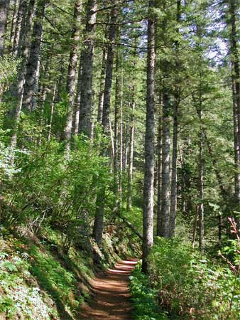
Starting my climb by 9:24 a.m., I headed
up the trail. The forests are awesome,
but it was difficult to get a great photo. I had harsh sun all
of the trip, and most professional pictures within the ancient
forests are done in diffuse light, in fog or overcast. However,
the sun made for better wildflower close-ups.
The footpath climbs up, then down to a
small saddle. There was some wet ground. Mesh wire covers some
steeper, short, and slippery spots on the trail. You can use stairs.
Wooden steps lead up the final, steep, stretch of trail.
I topped out at 10:47 a.m., a fair time
for the 1,600' gain. The view was
hazy, and the peaks all seemed backlit. I wished I had brought
more Kodachrome for the polarizing lens I use to clear up the
haze. I had only two 36-exposure rolls, as back-up, and for possible
prints. So, I had to be sparing on shooting film.
Clicking away with my digital cameras,
I saw as usual, many clear cuts, seen from most any vista point
in this part of the state. Saddle Mountain is the highpoint of
Clatsop County. None of the other mountains are that much to see,
compared with other higher and rockier ranges, with this being
a state forest. The distant Pacific Ocean and the town of Astoria
were the main features to be seen. Some other peaks seemed higher.
Sharing the summit with a few others, I soon headed down. So many
hikers were coming up. A few dozen people were out to enjoy, here,
today. I stopped for more close-ups
of the flowers, and soon was back down in dense forest. Side light
and my polarizer made for some nice slides.
Back to the car, I soon motored back to
the main highway, and continued west on U.S. 26 toward the ocean.
I stopped at a signed point where the largest Sitka Spruce grew.
Many tourists were stopping, too. It was nice for photos,
as in California with the Giant Sequoias. I deem it worthwhile
to see these specimens, appreciative of trees.
 Onto
U.S. 101, I headed north. Bypassing Seaside, I headed for Astoria.
With a stop at historic Fort Clatsop
National Park, where the Lewis and Clark Expedition had wintered,
I motored along some back roads, and came to the main streets
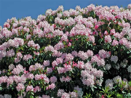
through town. I then figured on re-visiting the Astoria Column.
Lovely gardens with well-tended rhododendrons made for photos.
I motored up to the high hill, and paid the parking fee.
Onto
U.S. 101, I headed north. Bypassing Seaside, I headed for Astoria.
With a stop at historic Fort Clatsop
National Park, where the Lewis and Clark Expedition had wintered,
I motored along some back roads, and came to the main streets
through town. I then figured on re-visiting the Astoria Column.
Lovely gardens with well-tended rhododendrons made for photos.
I motored up to the high hill, and paid the parking fee.
The spiral staircase within the concrete
tube climbs to the nicest vistas
of the Pacific Northwest. Saddle Mountain made the sight to the
south. Astoria is a colorful town, and I snapped away with all
my cameras. This was an afternoon visit, as opposed to my morning
visit on my 2004 trip. The light would be different.
Back to town, I then resolved to motor
back to Portland via U.S. 30. Some smaller towns, of not much
interest, were passed through, and I snapped photos as I could.
There is only one good view of the Columbia River, as you approach
Rainier, OR. The official vista point is driven to, only on the
westbound side of the divided highway, mainly with a sight of
industrial development.
I had lots of time, so motored along without
rush. I shortly came into Portland, and then was on a freeway,
headed back to my motel. I had a nice meal, and soon was charging
up my camera batteries and watching TV.
Next