SOUTHERN CALIFORNIA ROAD TRIP,
WITH ROSA POINT (5,000+') 2X, INDIANHEAD (3,940+') 2X February
23-28, 2005
 Saving up again, this past month, for this shorter
term adventure, I couldn't sleep again, late Tuesday night. I
left home at about 2 a.m., Wednesday, to take Interstate 5 south.
It was nice driving with so little traffic, and there is not much
to see or take photos of, anyway, for the first few hundred miles.
Saving up again, this past month, for this shorter
term adventure, I couldn't sleep again, late Tuesday night. I
left home at about 2 a.m., Wednesday, to take Interstate 5 south.
It was nice driving with so little traffic, and there is not much
to see or take photos of, anyway, for the first few hundred miles.
Arriving in Pasadena, CA, by about 9:45
a.m., I strolled along Colorado Boulevard to get the flavor of
Southern California. The people here seem hard-working, and many
have a rough time. I snapped photos of the old town, with many
businesses. Someday I may be able to attend the famous parades,
especially the funny one. I took the historic Arroyo Seco freeway
headed toward downtown Los Angeles.
Coming first to Chinatown, I got out of
my car, and walked about this small scenic attraction. Then, I
motored through the garment district on my way to Little Tokyo.
I parked, feeding meters again, and sauntered about this section
of town. I like snapping lots of photos while traveling. There
was a cloudy sky, which foiled some of my photos, but added drama
to others. The light is sometimes better with clouds, and I enjoyed
how I got it, this time I was here. Revisiting the Go for Broke
memorial, I also visited a newer war memorial in a different part
of the Japanese Village.
 I
drove about in the downtown high rise area, wishing I had more
time to hike. We toured this area on foot, at night, on a Sierra
Club hike to feed the homeless during my Christmas time vacation
in 1998. I became lost looking for the I-5 freeway on-ramp, to
then take I-10 to 405, and then southeast to look for a cheap
motel. Finding one in Westminster, I fell asleep, without dinner,
by about 6 p.m.
I
drove about in the downtown high rise area, wishing I had more
time to hike. We toured this area on foot, at night, on a Sierra
Club hike to feed the homeless during my Christmas time vacation
in 1998. I became lost looking for the I-5 freeway on-ramp, to
then take I-10 to 405, and then southeast to look for a cheap
motel. Finding one in Westminster, I fell asleep, without dinner,
by about 6 p.m.
Thursday, I drove over to the Pacific Coast
Highway, CA 1, to see Newport Beach. Headed south, I parked at
Laguna Beach for a few photos. Doing the same, as well, in San
Clemente to walk a few blocks, I then connected up with Interstate
5. My motoring south to San Diego saw a traffic slowdown.
First visiting San Diego's Old Town State
Historic Park, I then sought to know what to see on my first,
in-depth, visit to this beautiful city. I came to the downtown
section to park at Horton Plaza shopping mall. This gives three
hours of free parking, with ticket validation, for shopping, or
for me, walking about this part of town. I hiked west on Broadway
to come to the pier. A cruise ship and an old aircraft carrier
made for sights to see.
Continuing southeastward along the bayshore
street, I passed by the impressive Hyatt and Marriott hotel highrises.
Heading back to the shopping mall, I noted the ongoing construction
of several other highrises and lofts, which seem to appeal to
city dwellers wishing in-town living to make do without a car,
perhaps. Coming back to my parking, I had my ticket validated
by getting some diet soda.
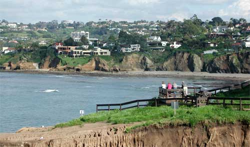
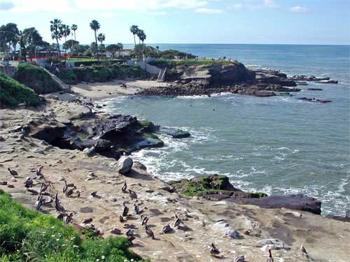
Motoring about to other sights, I wound
up in La Jolla, CA. This is another fine seaside town, with sights
(top two photos) of developed coastline, and a sea cave and pelicans.
I drove back into San Diego to pass through Mission Bay Park,
and to quickly stop on Harbor Island for a good seaside view of
the horizon line of highrises. 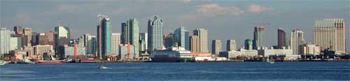 Going
then, to briefly see Balboa Park, I got another view of the downtown
area, and the freeway underneath me, while on a pedestrian bridge.
Going
then, to briefly see Balboa Park, I got another view of the downtown
area, and the freeway underneath me, while on a pedestrian bridge.
Motoring east on Interstate 8, I found
lodging in El Cajon. I devoured only a Rubio's fish taco with
two servings of rice, which helped with my crash diet.
Friday, I took the San Diego Trolley ($5
round trip or day tripper), the local light rail, back into San
Diego, and walked through the Gaslamp Quarter to photograph the
buildings, and get more views of the town. Returning to Horton
Plaza, people were lining up at the adjacent NBC tower to apply
for an audition to be on the "Apprentice" TV show. I
also visited the Seaport Village, and then took the red-painted
Trolley back to El Cajon.
Headed east again on Interstate 8, I enjoyed
the fine weather, and the sights of the green hills. Taking CA
79 north, I passed through Cuyamaca Rancho State Park, which was
almost totally devastated by a big fire a couple years back. I
had it in mind to re-hike a few HPS-listed peaks here, but, in
lieu of the former natural scenery, chose to head for Anza-Borrego
Desert State Park.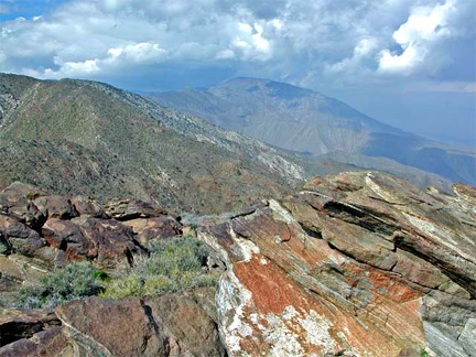
Stopping in rustic Julian, CA, for lunch
and more photos, I then took the highways east into the Desert.
I found many blooms to shoot, in this said-to-be-great year for
desert wildflowers. I did short hikes at Plum Canyon and along
the Kenyon Overlook Trail.
Asking about the forecast at the park visitor
center, I noted the heavy clouds, and saw lightning hit near one
of our peaks we'd climb this next weekend. After a salad dinner
in Borrego Springs, I drove to our meeting spot at the first peak's
trailhead. I wasn't sure if the trip was still on.
Lucky for me, a trip participant motored
in early, so I surmised the climbs were still a go. Rain fell
overnight, and I deemed this a possible wash. The forecast had
changed, in the TV report the previous morning, to rain all day.
My desert dawn broke to mostly clear skies,
and the appearance of our group, with a few cancellations. I shook
hands with the leaders, and we began our climb of Rosa Point at
6:50 a.m. Our group of ten was led up a wash, past many flowers.
I regretted being unable to stop, at length, for pictures of some
fine specimens of Desert Lillies. I have a concern of being too
slow, and holding back the group. The trip sheet advised of a
"deliberate pace" to top out in five hours. This was
necessary to return before dark.
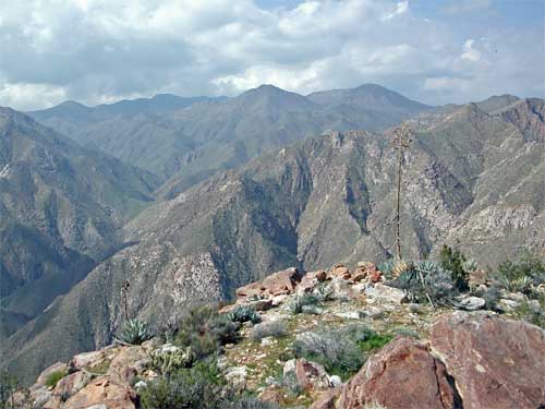
The leader took us left up to a ridge,
then along it, and down into another wash. We climbed up another ridge, and surmounted a few bumps. We were doing well on time.
My crash diet had helped. Reaching the top at 12:20 p.m., we had
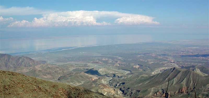
hazy views of the Salton Sea and the Coachella Valley to the north.
Rabbit Peak appears to the north (fourth photo from the top).
My Adobe software helps to clear up these views.
After lunch, the group was very cooperative
for digital group summit photos, one shot at full resolution,
for the DPS newsletter. I took my own picture separately, and
then we chose an easier route down. This use trail runs the gamut
of the ridges back to the wash, at the base. We encountered another
group still climbing up. It was a Sierra Club training trip, teaching
people how to explore in the wilderness. Continuing down, I liked
snapping away at the route of ridges, and the views downward.
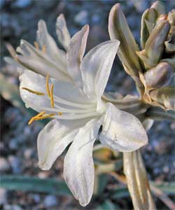 I
got my photos of the desert lillies, and figured to stay over,
past the weekend, for more time to photograph wildflowers. Back to the cars by 5:18 p.m., we enjoyed our customary tailgate party,
with food and drink, then motored over to nearby Palo Verde Wash
to find a good campsite. We had more drink, chips and dip, salads,
then chicken posole soup, chili chicken, then cookies, and dessert.
Lanterns provided the light to enjoy each others' company.
I
got my photos of the desert lillies, and figured to stay over,
past the weekend, for more time to photograph wildflowers. Back to the cars by 5:18 p.m., we enjoyed our customary tailgate party,
with food and drink, then motored over to nearby Palo Verde Wash
to find a good campsite. We had more drink, chips and dip, salads,
then chicken posole soup, chili chicken, then cookies, and dessert.
Lanterns provided the light to enjoy each others' company.
Up early Sunday morning, I left to get
some coffee and potatoes in Borrego Springs. I drove to the Borrego
Palms trailhead ($6 day use fee) to see the group arrive before
8 a.m. We took our time to ready, then started up this second peak at 8:07 a.m. Following the trail to the palms, we continued
past where only adventurous tourists might go. The former string
of palm trees along the creek had been wiped out by a flash flood
some years ago. The canyon floor was completely rearranged. We
had a delay finding the route, but persevered and found a way.
I needed a hand to surmount a mantle move up a rock shelf.
Then it was time to leave the canyon floor
and climb the peak. We found the correct, south ridge, that leads
up Indianhead. It was steep, and full of flowers. I wished to
photograph these in detail, but the seven of us climbed fast.
The ridge becomes less steep, and a cool breeze came up. I had
taken only two liters of water. An additional can of soda would
have been nicer.
 The
climbing route gradient became much easier, then we came to the
high ridgetop. We wedged through a slot, where I picked up someone's
hiking pole. We summited again, in 4.5 hours, and again had a
hazy view. As everyone else had lunch, I concentrated on photos.
I really should bring a bite to eat, as energy loss affected my
speed on the descent. After many photos of the views, with the
one west to higher peaks, and our own group summit shots, we started
down a different way. We would do a loop, exploring two routes.
The
climbing route gradient became much easier, then we came to the
high ridgetop. We wedged through a slot, where I picked up someone's
hiking pole. We summited again, in 4.5 hours, and again had a
hazy view. As everyone else had lunch, I concentrated on photos.
I really should bring a bite to eat, as energy loss affected my
speed on the descent. After many photos of the views, with the
one west to higher peaks, and our own group summit shots, we started
down a different way. We would do a loop, exploring two routes.
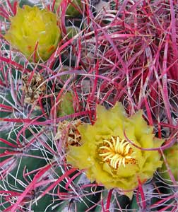
The downclimb went fine at first, but my
lack of enough water brought on some personal fatigue. Another
climber was also slow. We had some 3,000 feet to descend, all
steep cross-country, with virtually no use trail at all. I did
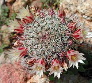
see a few ducks, but the terrain was rough. The sweep leader pointed
out a tiny, delicate, flowering fishhook cactus. I stopped, then,
for some quick close-ups.
I was getting tired. I took a big step
to lose my balance on a rolling rock. Suffering some tiny loss
of hand, blood soon covered my palm. I requested a first-aid stop
somewhere along the line, as my wound was pretty minor, but the
fast part of the group got way ahead and below. I was beginning
to make mistakes. Water does delay fatigue! I went slower, then
we had concerns about the time. Finally, as the angle of the terrain
became less steep, they halted. I could take a last drink of my
remaining water. This helped.
Downclimbing on, some of us spotted a small
herd of bighorn sheep on the slopes to the left. It was too dark
for good pictures, and they blended in too much with the rocks.
I tried four telephoto shots, but the others tended to their photography
in a better state of energy than me!
 I
got ahead, then saw tourists on the main trail below. I became
separated from the group, but was then on the park trail. They
came down a slightly different part of the lower wash, and we
were united once again. The climbing was over!
I
got ahead, then saw tourists on the main trail below. I became
separated from the group, but was then on the park trail. They
came down a slightly different part of the lower wash, and we
were united once again. The climbing was over!
Back to the trailhead parking lot by 4:30
p.m., we had drink and more food. Park rangers showed up, then
a fire truck, a Highway Patrol wagon, and a Sheriff's deputy.
Someone had slipped somewhere on the rocks. This was a minor rescue.
It all was in fine hands. I shook hands and said my thanks and
goodbyes, then departed the area. A paramedic ambulance sped by,
then a helicopter was heard, as I motored back to Borrego Springs
to decide what to do.
I declined dinner, as I figured then to
drive to get a room, instead of camping, again, somewhere. I was
hurting a bit, but had drunk lots of water. I headed east on S-22
to CA 86 north. I would look for cheap lodging, maybe at the Salton
Sea, or then Indio. Night fell, and I saw no low advertised rates,
so I figured to skip the additional wildflower photography to
get home earlier. That can wait till another time.
Snacking with some fast food, I came to
San Bernardino and obtained a $40 room rate. At a nearby restaurant,
having a bowl of chicken tortilla soup and fresh baked bread would
hold me for that night.
 Monday,
I was on the road again. It was reported on an L.A. TV station
channel to be rain for the next few days in Northern California.
I'd go home anyway, this day, to save some cash. Coming to U.S.
395 north, I asked at Kramer Junction about road conditions. I
got a 1-800 number to call from a pay phone, for free, to find
there must be storm conditions up north, as chains were then required
to drive over Echo Summit. So, I conservatively opted not to drive
home on 395. But, as I saw later, it would have been beautiful.
Monday,
I was on the road again. It was reported on an L.A. TV station
channel to be rain for the next few days in Northern California.
I'd go home anyway, this day, to save some cash. Coming to U.S.
395 north, I asked at Kramer Junction about road conditions. I
got a 1-800 number to call from a pay phone, for free, to find
there must be storm conditions up north, as chains were then required
to drive over Echo Summit. So, I conservatively opted not to drive
home on 395. But, as I saw later, it would have been beautiful.
Going west on CA 58, the new freeway now
completely bypasses the town of Mojave. I had some rain, but then
going north past Visalia, the clouds parted, and the sun came
out. I enjoyed some good fuel efficiency, about 45 mpg, on this
final section of my drive home.
I did some 18 miles with 8,000' gain on
the peaks, with maybe 10 more miles about towns, and other trails.
I spent some $275 total, driving some 1,380 miles, all said. Only
about 33 gallons of fuel needed to be used for the entire drive.
I shot about 1,200 digital images, and 22 frames of Kodachrome.
Using from four layers to just a T-shirt,
I always wore long pants, with EW bottoms in the mornings, generally.
I used only my old cheapo sleeping bag, camping, with no working
zipper necessary. There were a few mosquitoes in the State Park,
and a tick was said to be seen. During the weekend, I was unable
to recharge my digital camera batteries, so I had to conserve
on my digital shooting. I would probably have taken twice as many
pictures on the peaks, if not for this dictate.
Seeking a partner to climb some more desert
peaks this season, I hope for more photos of this spectacular
show of wildflowers. It's nice to be able to enjoy this wonder
of nature, obtaining sights that are seen specially by the best
desert explorers, thanks to the peak sections that climb all these
glorious, desert mountains!
BACK TO PETE'S
THOUSAND PEAKS HOME PAGE