TWIN PEAKS (910') 5X AND MT. DAVIDSON (925') 3X January 19, 2005
Tired of the Valley fog, and a bit upset at how much it was costing me to retain a pair of old, organic cotton jeans (for pocket repair--they don't make them anymore), and to get two new pairs of organic cotton pants hemmed, I chose to visit this beautiful city, once again. There would be no problems with muddy trails or saturated ground. All of my hiking was to be on concrete sidewalks and pavement, aside from the mostly dry trails on the peaks.
I departed home at a good enough hour, and motored south on the river road (CA 160), over the Antioch Bridge, then to the Pittsburg/Bay Point Bay Area Rapid Transit (BART) station. The lot was full. I parked on a side street, and walked into the station. The one-way fare to downtown San Francisco was now $5. Whew!
The ride, again, was smooth and pleasant. I went from fog to hazy sunshine. BART takes about an hour to get to the Embarcadero BART Station, and I was soon looking up at the impressive highrises. Sauntering southwest along Market Street, I began snapping photos. Most citizens here are used to tourists. Most all was about the same.
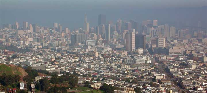
Making good time, I forked right on 17th Street, which comes to Twin Peaks Boulevard. Using the road shoulder and some shortcut trails, I soon gained the vista point parking, with scopes available for viewing. The hour was Noon. It was a bit hazy, but the images will be improved by software. I like this vista (above)--it is great for visitors to see the whole range of the downtown area.
This wouldn't be a peak climb if I didn't
climb the stairs to both of the two bumps. A bit easy, maybe,
with roads encircling the two bumps, but I did hike this from
the Embarcadero BART Station, some 4 miles away.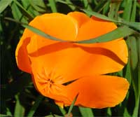
Some flowers were already blooming, with a few golden poppies. Early spring! I walked south down Twin Peaks Boulevard to Portola Drive, and then on side streets to the famous (to county highpoint baggers) bus stop. This marks the start of the short trail up to the top of Mt. Davidson. This peak is the highest, natural point of the City and County of San Francisco. Sutro Tower, to the northwest, stands tallest. Hikers working on the California County Highpoints list will come from a long way away to hike this peak! I snapped more photos of the gigantic cross that is atop the clearing in the eucalyptus forest. Years ago, someone had placed climbing bolts in this religious structure. They are now removed. Also, an Armenian-American association had purchased the land here, to spare the city from legal action, perhaps, to enforce religious freedom. Access is the same.
Not tarrying at all, I hiked southward through enchanting neighborhoods to the City College. I came to Balboa Park BART Station. It was only early afternoon. With former hiking partners, we would be headed home. But, I am game for more hiking!
Debarking at the Montgomery Street BART Station, I hoped to see more of this beautiful city. I went by Union Square. It was sunny and nice. Hiking through the Stockton Tunnel to Chinatown, I saw there were lots of people out, enjoying. I snapped more photos, although the streets were half lit, with the low sun. I continued on to North Beach.
I got the urge to climb up to Coit Tower.
The signs pointed out the stairs upward. This was good, nice,
exercise. I recorded the vistas and toured the tower murals. Still
looking to wait somewhere about town to avoid the rush hour, I
went back into North Beach, then Chinatown. Not hungry, I declined
my favorite, a special type of won ton soup. I found a fast food
restaurant to rest, sip drink, and have a sandwich. Magic hour
was occurring.
I snapped photos of the interior of the Hyatt, which is spectacular, award-winning architecture, and then finally meandered to the nearby BART station. Throngs of commuters were still headed home. Well, I'll get home early. Some day, I will stay about to snap photos of the neon and night scenes.
I got a seat, once past Orinda, then watched the clogged up traffic on the freeway as we zoomed by. Back to my car by 6:25 p.m., I got on Highway 4. A slowdown was in progress. Looking for gas, I obtained some, and paid the $3 toll for the Antioch Bridge, northbound.
Very light traffic contrasted with the congested Bay Area roads as I motored along the river road. Then to I-5, I was doing 70 mph as the freeway was good.
I had hiked maybe 10 miles with 2,000' gain, round trip. No one came out to bother or annoy me, and the BART ridership, in my cars, was pretty quiet. A difference compared to other towns!
My car sipped up only some 4 gallons for my day's 135 miles. I shot close to 400 images, with no movie clips. I shelled out $11.30 for BART, with a few dollars for drink and food.
I always wore my standard, three, top layers, with EW Capilene under my pants. I donned a parka at times, and there was wind on the peaks. It was chilly, but I had opportunities to warm up, with plenty of indoor areas to go into. It is a good look at the real world to see so many busy people, working hard, and living as best as they can.
BACK TO PETE'S THOUSAND PEAKS HOME PAGE