 Resolving
to catch the local, Northern Sierra, fall colors, I would drive
to Highway 88 and Hope Valley, the best and most accessible stands
of aspen trees. It usually peaks about this time.
Resolving
to catch the local, Northern Sierra, fall colors, I would drive
to Highway 88 and Hope Valley, the best and most accessible stands
of aspen trees. It usually peaks about this time.HOPE VALLEY FALL COLORS AND ROUND TOP (10,381') 17X October 10, 2005
Tending to sleep late, and doing little during this nice spell of fall weather, I decided I had to do something. I need to get into good condition for a moderate Desert Peaks trip, so did some 25 miles of walking on the Parkway, this holiday weekend. But this was not enough. I need to do some gain.
Resolving
to catch the local, Northern Sierra, fall colors, I would drive
to Highway 88 and Hope Valley, the best and most accessible stands
of aspen trees. It usually peaks about this time.
Unable to fall asleep early, I stayed up, looking at my past trips on my website. Soon, it was past 4 a.m., Monday. The holiday makes for a good time to hike and travel. I readied my gear, and carried my stuff out to my car.
Motoring eastward on U.S. 50, the traffic wasn't real light, for this time of day. I stopped at an all-night restaurant in Placerville for a good breakfast. It was still dark as I finished. Onwards and upwards toward South Lake Tahoe, I stopped quickly for sunrise pictures from a pullout east of Echo Summit. Turning south on CA 89, I motored over Luther Pass. I beelined to the rustic resort along CA 88/89, famous for its cross-country skiing ops and special lodging amidst the groves of aspen. Getting a can of soda (1.50), I shot pictures of the good yellows in the trees, in the shadows before the sun hit here.
Continuing back westward, I passed into Hope Valley, a large, mostly flat, area which has been spared development. Many groves had turned, well. I made a few standard stops for photos, as I have been coming here for many years to record the colors. I'd say it was 80% turned, and a 7 or 8 out of 10, for the display.
My fall mountain photography quickly done, I motored up to Carson Pass. I found the fee parking regulations had been changed to cover the entire month of October, now. No free loopholes, anymore. It is a self-pay fee of $3. Regretfully, I had not brought my Golden Eagle Passport with hologram, which would have sufficed for the fee. I thought about all this for awhile, then paid my money and readied for my peak climb.
Only one other vehicle was in the lot. There was no wind. Starting by 8:46 a.m., it would be a nice day. I noted the changes along the trail, and it proceeded in a short semi-circle, which might confuse some. Past Frog Lake, though, the trail soon heads for the peak. I came to elegant Winnemucca Lake in an hour. No campers. I was wearing my new, $40, mail order, Patagonia jacket, with jeans. It was to become quite pleasant in the afternoon, with other hikers in T-shirts and shorts.
Climbing up the trail, I left it at its apex before the footpath's 100' descent to Round Top Lake. I connected with the use trail up the peak, and trudged upward, with a good time. Passing a large snowfield, I discerned some frozen snow or ice. Some remnants of fresh powder lay across some high northern slopes, but I was never to step on snow, today.
I recalled the route well enough, and came to the first, lower, hikers' summit. I wished to photograph the route better than before. Basically, one stays on the right (south) side of the main summit crest, with some scrambling and downclimbing. I slid slowly on my toosh, tearing a small hole in my jeans, down the loose, rubbly, class 2 section, before the notch next to the summit mass. Crossing over the steep, rubbly gully, I clambered up the easy rock ledges on the side of the summit mass. On top at 11:33 a.m., I took off my pack for a long stay.
Photographing the view, I read the register,
and placed a needed, new book. Little or no wind. Lake Tahoe,
the Sweetwaters, and other visible features reminded me why I
like this peak.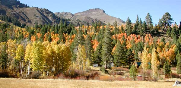
I finally started down at 12:17 p.m. I had encountered one climber while going up, and had hoped more people would join me on top. The gas prices (2.849 for me, today) must have kept most home.
Looking at a side use trail well down from the ridge, I wondered how it went, appearing to be as difficult as the higher route. This recon brought me out of position for the downclimb, and I realized I was going the wrong way. I scooted down, partly on my rear, again, then climbed up a chute, and came back to the familiar use trail.
Soon, I was off the steeper part of the peak, and shortly back down to a trail junction at Round Top Lake. More hikers came up from Winnemucca Lake, and we had brief but pleasant chats. It was clear sailing back to the parking lot, me arriving there at 3 p.m.
Motoring back east, I wanted to reshoot the Hope Valley colors, with afternoon light. Perhaps it was a bit better. I then motored back westward over Carson Pass, and down CA 88. More colors presented themselves. I took the Mormon-Emigrant Road back to U.S. 50, stopped for fast food, then shortly came home.
Hiking some 9 miles, I had done some 2,000' gain. I shot 222 images. Using about 5 or 6 gallons of gas, I had driven some 240 miles.
The colors should remain till a week or two from now, depending on the wind. After seeing both Utah and Colorado, the fall color ops here are pretty modest. I saw some ice formed in puddles, and I look forward to a nice winter. I will hope to get another modest gain climb before my desert trip, and maybe I'll get to do some skiing, come the snows.
BACK TO PETE'S THOUSAND PEAKS HOME PAGE