FALL 2005 SOUTHWEST LOOP: Wildrose Peak (9,064'), Pahrump Point (5,740') 2X, Stewart Point (5,264') 3X, Sandia Crest (10,678') October 25-November 6, 2005
Well,
it was time for another road trip. The ten day forecast looked
excellent, and the DPS climbs were a "go." I made a
quick ready, Tuesday morning, the 25th, and left home Tuesday
afternoon. I stopped at the Patagonia Outlet to buy another organic
cotton T-shirt (17), and got my 14th floor room at the major hotel
casino in Reno, NV.
Up early Wednesday, I motored down U.S. 395 to gas up in Carson City, NV (@2.609). Seeing most of the fall colors in the aspen were gone, I noted the good color left in the cottonwoods in the Carson Valley, Antelope Valley, the Owens Valley, and elsewhere.
Hours later, down U.S. 395, I stopped to see the newly prepared exhibits at Manzanar National Historic Site. Touring the displays, I watched the digital movie about life in camp, for thousands of interned Japanese-Americans, during World War II. The Park Service did a great job in spending probably millions for this high tech remembrance.
Continuing on to Lone Pine, CA, I had an early dinner before proceeding to Stovepipe Wells in Death Valley National Park. Camping there, with a $10 fee paid to a machine, I slept in my car.
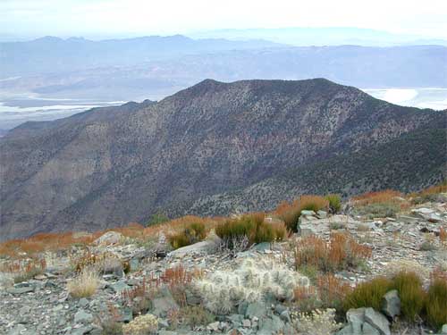
Thursday, I woke up to view the sunrise as I drove to the Charcoal Kilns parking area, to start my hike of Wildrose Peak. An easy 4.2 mile trail leads to the top of this
minor summit. Topping out after two hours, I noted the views (eastward
view, top photo, right) and weather. Clouds added some drama.
Encountering some other hikers on my way down, I was back to the
trailhead by about noon. Driving back to Stovepipe Wells, I explored
the nearby dunes. I got a shower (3) at the lodge swimming pool
area. Great! There was an interesting
sunset. Dinner at the nearby restaurant was fine enough, that
night.
Camping again at Stovepipe Wells, I woke up early again, Friday,
to have breakfast, then an early morning walk to climb the nearby
highest dune. I had lots
of time today. I hiked about the Devils Cornfield, then took the
main park road south. A hike up Golden Canyon was followed by
the auto tour along the newly re-opened Artist Drive. I visited
Badwater, then motored south over to Shoshone, CA, where I was to meet
the DPS group the next morning. Upset about camping in the dark
alone, I was joined in the night, as I slept, by others for the
climbs this weekend.
We convened at 7:30 a.m., Saturday, for the peaks this weekend. The cafe doesn't open till 8 a.m., now. We caravanned to the roadhead along CA 178, parking along the highway.
Our first peak was Pahrump Point. This is a good, stiff, climb. Starting at 8:23 a.m., the group was led up a closed-off dirt road, then to a long wash. I enjoyed this route, having done it before in 1993. The banding in the rocks was magnificent. Pretty much, we followed the DPS guide directions, and I digitally re-shot all the features of this route. We summited in due time, about 4 hours, and got the clear enough views of the surrounding desert, and, of course, Charleston Peak, and the sprawling town of Pahrump, NV, to the northeast.
Some had turned back. We started down to get back to the cars by late afternoon. The plan to go to Tecopa Hot Springs was put on hold for another time. We went to a campsite on private land, with permission, near Shoshone. Having our nice potluck meals, with a campfire, we retired for the night.
Sunday, only some of us chose to climb Stewart Point. We motored up the CA 178 highway, again, and parked by the shoulder. Two other hikers joined us. Again, we followed the DPS guide directions, and shortly topped out after three hours. The rock is brittle and sharp. I took care not to cut myself. I didn't like the steep, loose, rubbly, downclimb much, but was so elated at our safe and successful finish.
Back to our cars, I thanked the leaders and said my goodbyes. So, at 2 p.m., it was onward and eastward for my big road trip to Northern New Mexico, and other parts of the Desert Southwest. I passed first through Pahrump, NV. Eastbound on NV 160, I viewed Red Rock Canyon NCA, from the south, to enjoy the late afternoon.
Coming to the Vegas Strip at magic hour,
I had quite the time to shoot the lights and neon. Parking at
the Bellagio, I snapped
pictures of the nicely decorated Conservatory, and took movie clips (46.1 MB, 320 x 240 pixels) of the dazzling, synchronized, fountain show. With a few
shots of Paris at night, then, it was a memorable photographic
moment for me. 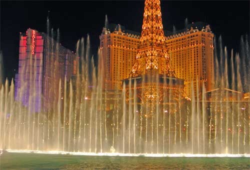
Spending big, for myself, I paid nearly $20 for a plate of Singapore noodles. About triple the price than elsewhere, I was having a good time. My initial plan was to make a big bet to decide whether to head on, eastward. I had already made a small win in Reno, so figured to make my trip, regardless. The forecast remained good. So, no $50 play on one hand of 21! I motored on to get a local motel room, and more fast food for dinner.
Leaving early, Monday, I headed south, in the pre-dawn, over Hoover Dam, then onward to Kingman, AZ. I was to motor east along Interstate 40. Whizzing at 75 mph through Arizona, I came to New Mexico in mid-afternoon. I was advised to make a scenic side trip to visit El Morro National Monument, and part of El Malpais National Monument, as well. I would make good use of my Golden Eagle park passport on this trip! Back to I-40, at Grants, NM, I got some inexpensive lodging. A small cafe offered my first taste of New Mexican food.
Tuesday, I toured more of El Malpais National Monument, hiking, and shooting more pictures. Hiking the Narrows Rim Trail and seeing more, I realized I would have to conserve my available memory, so adjusted my camera settings to use higher .jpeg compression. I stopped at the visitor center. Coming to Albuquerque, NM, by about noon, I hiked in the newer Petroglyph National Monument. A disappointment, I had seen the rock art here. The top of Mesa Point made for a sight. Then I motored on to Old Town Albuquerque for more photos, and something to do. Walking the downtown area for more magic hour photos, I then got my motel room, as I was to secure, each night, for the rest of this trip.
The computer was down at the full service copy shop, so I couldn't transfer my photos to my two $20 flash drives, clearing up room on my regular memory cards to shoot more pictures. I had more New Mexican cooking for dinner, then looked for a store to purchase a special DVD release. Done, I went back to my motel to sleep.
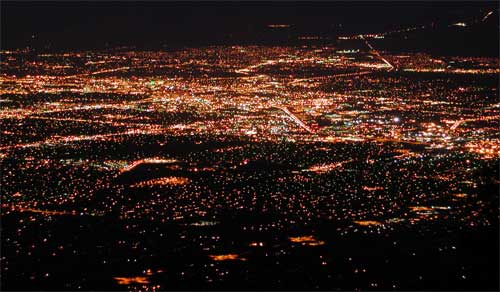 Awaking
so very early in the morning again, I motored in the dark up to
the top of Sandia Crest. There, I shot the spectacular view of
Albuquerque at night. The sun rose, and the clouds
turned pink. This drive-up I will count, with photos I would
worry about keeping, the rest of this trip.
Awaking
so very early in the morning again, I motored in the dark up to
the top of Sandia Crest. There, I shot the spectacular view of
Albuquerque at night. The sun rose, and the clouds
turned pink. This drive-up I will count, with photos I would
worry about keeping, the rest of this trip.
Taking a scenic side road, NM 165 to NM 14, northward, I shot more photos, and enjoyed the morning. Madrid, NM, was a surprise.
Coming to Santa Fe, NM, I looked for another full-service copy shop to save my photos to my flash drives. I needed a memory card reader, so I had to try to get one, somewhere. I wasn't sure if I would need the extra memory, anyway, so took a walking tour of old Santa Fe. The nearby State Capitol wasn't much to see.
I got the memory card reader ($10), then spent my money to rent a Power Mac. I was able to transfer some of my photos. Getting another affordable motel room, I enjoyed even more New Mexican dining.
Sleeping later than normal, I motored onward to Bandelier National Monument. I made a photo stop at White Rock Overlook, and found some cheaper gas. I did my hiking at the Monument on easy trails, shooting some nice fall colors, in the form of cottonwoods.
It was then up to Taos, NM, a must see and do. The canyon along NM 68 was filled with golden cottonwoods. The historic part of town didn't take long to tour. I had a southwestern type special lunch, then headed westward, then northward. I had reached my apex of my road trip, east. The bridge over the gorge of the Rio Grande made for more nice photos. I took U.S. 64 to U.S. 84, crossing over a pass with what would have been fine fall colors, earlier. All new territory for me!
Coming then to Pagosa Springs, CO, I found the local park, Reservoir Hill, to view the sunset, and see the town from above. I had secured another room for what would be a freezing night, with frost on my car in the morning. Anyway, a trendy, new burger joint made for dinner.
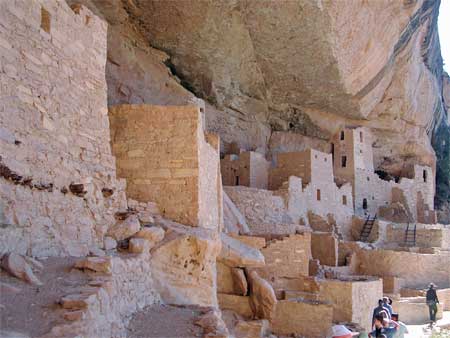 After
breakfast, Friday, I motored on west along U.S. 160. Skipping
a stop in Durango, CO, I took the side trip, further west, to
Mesa Verde National Park. Very worthwhile to see! Cliff Palace (left photo), an ancient ruin, is guided by a park ranger. Good
views, from up high, are had, as well.
After
breakfast, Friday, I motored on west along U.S. 160. Skipping
a stop in Durango, CO, I took the side trip, further west, to
Mesa Verde National Park. Very worthwhile to see! Cliff Palace (left photo), an ancient ruin, is guided by a park ranger. Good
views, from up high, are had, as well.
Passing through Cortez, CO, then, over on U.S. 491 to Monticello, UT, then north on U.S. 191, I came to Moab, UT. A setting sun had accentuated the color of the red rock. The motel room rates were lower for the off-season, so I got the best lodging deal. I had a fine enough meal, much more reasonable than during peak travel times.
Sleeping well, I awoke early, Saturday, again to motor to Canyonlands National Park, and caught the sunrise at Grandview Point. Trying for good photography from this magnificent view, I soon finished, and motored back to hike on the Mesa Arch Trail. Doing more photography there, I stopped at the visitor center, did more photography, then later got a drink at a mini-mart back along U.S. 191. Then I headed back south to Arches National Park. Seeing some rock climbers, I digitally re-shot the main features I already had photos of, taken back in 2000. I hiked the Balanced Rock, Windows, and Double Arch trails, once again.
Getting to be late afternoon, I did a leisurely
1.5 mile hike to Delicate Arch to try for more beautiful sunset
photos. It was good, with several other photographers looking
for great scenics. I shot with both my film and digital cameras,
more with Kodachrome, now, since I had plenty of film, and my
digital memory reserve was getting low.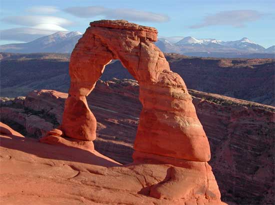
After a fair sunset, I headed back to Moab to get lodging again, and another fine dinner.
My last night, I hadn't slept at all. I took off at 4:30 a.m., to spend $25 or more on diet soda, coffee, and candy to get me home. Thinking at first to see the San Rafael Swell at dawn, it was too early for that. So, I took U.S. 6 north to I-15, then home on I-80.
Filling up with my cheapest gas, for the trip, in Winnemucca, NV, at 2.529, I had a quick meal there. After a torturous drive, getting sleepy, then stopping several times to doze a bit, I pulled in, home at midnight, Sunday night.
I had hiked some 44 miles, with 11,250' gain. I drove about 3,250 miles. Using 77 gallons, my trip average fuel efficiency was about 42 miles per gallon, then. I shot some 2,800 digital images and movie clips, with over five big rolls of Kodachrome. Spending about $870, total, I came back with a memory card reader, poster, and DVD movie. Great memory, too!
I rarely wore 3 layers, with mostly my wearing a new polyester jacket over a T-shirt. I used regular light hiking boots for the peaks, low cuts for driving and easy park trails, and a few day packs for hiking and storage.
The weather was mostly fine, with plenty of sun. I had a few flakes of snow in Northern New Mexico as I was driving into Colorado over a pass. I got a bite on my leg somehow, but saw no ticks or mosquitoes. I only saw deer, birds, and lizards, for wildlife.
 To
summarize, I spent 12 nights on the road, camping in my car for
four of them. Visiting nine separate parks or monuments, I did
cross the Continental Divide twice, and walked about several towns,
new for me, and traveled a few more sections of highways and Interstates.
There were plenty of beautiful fall colors, yet, in cottonwoods,
and other trees and shrubs. I even saw a few flowers.
To
summarize, I spent 12 nights on the road, camping in my car for
four of them. Visiting nine separate parks or monuments, I did
cross the Continental Divide twice, and walked about several towns,
new for me, and traveled a few more sections of highways and Interstates.
There were plenty of beautiful fall colors, yet, in cottonwoods,
and other trees and shrubs. I even saw a few flowers.
The highest peaks all had snow on them, so I wouldn't do them, solo. Leaving my ice axe at home, I brought only the usual, easy hiking gear. I had my trunk and rear seat full of packs and storage, with little room for a carpooler's gear. I'd love to have had company, but there were no takers for such a long time together.
I received a few scratches on my arms, but suffered no equipment damage or loss. Using most all of every bit of digital memory that I had, I made use of three cameras. I completed my longest drive for a day, nearly 900 miles, on my way home.
BACK TO PETE'S THOUSAND PEAKS HOME PAGE