 OLD
DONNER PASS GRAND SLAM 4X September 13, 2004
OLD
DONNER PASS GRAND SLAM 4X September 13, 2004OLD
DONNER PASS GRAND SLAM 4X September 13, 2004
The word for today was, "WIND!" The strong breeze swept across the Sierra Crest, and made a bit cool what would have otherwise been a nice day.
I enlisted Hiker J again, for this Net announced, four peak hike about the Old Donner Pass area and south. Despite my offering this free event on three, climbing or hiking, websites, there were no other takers.
We met along Interstate 80, Monday at 8 a.m., off the Soda Springs Exit, then car caravanned to the Pacific Crest Trailhead near the Old Donner Pass Highway. No other cars were parked, so we got good spots. Starting off at 8:19 a.m., we took the good trail with gusto. "J" was doing much better than on the last peak climb. He had along his hound dog, who responded nicely to voice commands.
Making good time, we soon came to the trail section along the side of Mt. Lincoln. Signs gave the distances. Dropping down some 400 feet elevation, the trail rolls along the scenic Sierra Crest. Fall is coming. The grasses have turned, and we saw a bit of color. Few wildflowers are left. Absolutely no bugs, due to the 25-40 mph winds.
I decided to change the order of peaks. Anderson Peak has the most steep cross-country, so it was nice to get that over with. We stopped in the Sierra Club's Benson Hut, which was clean and stocked for the ski season. I have stayed here twice or thrice, and it is a marvelous ski backpack experience!
The scree trail heads up from the hut, and over to the west. I had concerns for the dog. She did well enough, climbing to the top of Anderson Peak, and we summited by about 11 a.m. Lots of time to bag the others! I wound up leaving some three new register books on the peaks--all with the old registers full. Would somebody please help me in doing this?
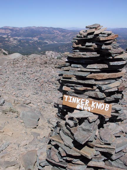
Back to the PCT, we made good time, headed for Tinker Knob. We saw maybe five other hikers leave the top. I wished to chat with them, but they took a different route down. The dog successfully climbed the class 2 on this peak, and we topped out by about Noon. It was beautiful out of the wind, on the lee side of the summit rocks. I began snapping away. "J" doesn't have a digital camera. Well, I still, too, use film, although not on such a local peak.
In our hour on top, I shot away, placed a new book in the ammo can, and then chose to shoot a few movie clips of us, acting exuberantly, with such a good climb.
 Headed
down at 1 p.m. exactly, we had a long walk, with mostly downhill,
left for us. The time went fast as we came back to the ski area,
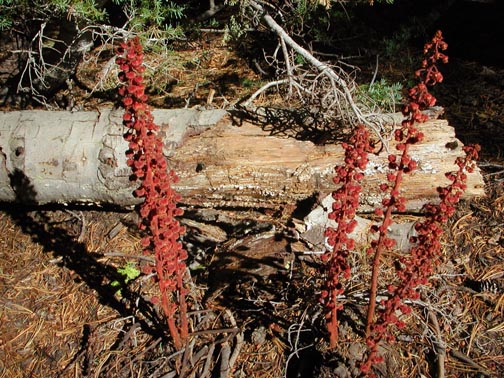
and then took the upper loop trail to the top of Mt. Judah. I
spotted some pine drops, a relatively rare, reddish, saprophyte.
Nice photo (left).
Headed
down at 1 p.m. exactly, we had a long walk, with mostly downhill,
left for us. The time went fast as we came back to the ski area,
and then took the upper loop trail to the top of Mt. Judah. I
spotted some pine drops, a relatively rare, reddish, saprophyte.
Nice photo (left).
The prayer flags were gone, but a sign marked the peak. I went over to bag the northern bump, then we hiked down to catch Donner Peak. Some youths were sitting about, but I guided us to the top, quickly. "J" says he could attend yoga class this night, so fast was our pace. The dog couldn't climb the steep sections of rock, so it had to be tied to a boulder.
I summited and placed a bigger set of cans and book, hopefully to last for a few years. I came back to "J" tending to the dog, then we hiked briskly back to the PCT. Back to the cars by 5:25 p.m., we quickly motored off.
"J" treated me to a drink and sandwich at a cafe along the old highway. This was in compensation for the camping fee I paid, for both of us, last weekend. Parting ways, I motored back to I-80 and stopped quickly, before getting home. I easily e-mailed some of the photos from today, to him. I think he'll get a big kick out of the movie clips!
We hiked some 16.5 miles with 4,000' gain. I drank up my three liters of water, and ate nothing on the trail. I shot about 235 digital photos and movie clips. My cash expense was only some $18. I used maybe a third tank of fuel, for my 200 or so miles.
BACK TO PETE'S THOUSAND PEAKS HOME PAGE