COLORADO FALL COLORS ROAD TRIP September 27 to October 2, 2003
It
was time for a peak of a different sort--the height of fall colors
in the Rockies and Great Basin. I had always sought to vary my
activities, not always doing peak climbing. Being a big photography
buff, I have long heard of the great photo ops in the San Juan
Mountains. From my winter trip in 2002, I knew there were plenty
of aspen. I regard this as my greatest effort to capture this
natural transition in the high mountains.
I woke up early on Saturday, the 27th. I left home at 4:30 a.m., and set out with over 1 GB in memory cards and eight rolls of Kodachrome. I saw from the Internet that the colors were approaching "peak" in some areas. The forecast was good. Snow had dusted the high peaks in Colorado.
I never had any great apprehensions or worry about this trip. I wouldn't be doing any risky solo ascents, in unfamiliar terrain with freezing lows at night. Colorado has had the highest rate of West Nile Virus cases, but I never saw any mosquitoes, the prime carriers of this disease.
Making great time eastbound on Interstate 80, I passed through Nevada with good speed. Gas is significantly cheaper out here. To save one night's room expense, I declined to stop over in Wendover, UT, and motored into Salt Lake City and onto Interstate 15. I had stopped for shots of distant colors in the Nevada's East Humboldts, and the Utah Desert ranges and the Wasatch Mountains. They were all prime!
Taking U.S. 6 to Interstate 70, I chose to lodge in Green River, UT, where I knew room rates are low. My day's travel was perhaps the longest drive I have ever done in one day!
Up early Sunday, I headed east on the Interstate along the Colorado River, and came to Glenwood Springs, CO. Lots of travelers. Taking CO 82 to Aspen, CO, I hoped to accomplish another "been there, done that," sort of thing. I took the shuttle bus to Maroon Lake, and photographed the famous Maroon Bells. This is perhaps as great a view as Yosemite Valley, from the viewpoint past the tunnel on Highway CA 41. I snapped plenty of Kodachrome to serve for old fashioned slide shows and prints. This made good back-up should my digital hardware somehow fail.
Back to my car, I parked in the pleasant town of Aspen. With thoughts of lavish wealth with grandiose mansions, I was surprised to see that this town was rather modest. I've seen better homes along the California Coast! I strolled about the streets and malls, seeing that there was plenty of landscaping with modest sized, planted trees. Other ski towns aren't so livable. I didn't have time to enjoy food or drink, as I wished to record the colors further along.
The drive up to Independence Pass (12,095') was filled with more gorgeous views of vast expanses of aspen. Cottonwoods and willows also added to the display. The parking area at the Pass was breezy, but little color existed up here. I continued down east to U.S. 24, then north a short ways to Leadville, CO. I had visited this highest of towns in 1978, to climb the two highest Colorado peaks, Mts. Elbert (14,433') and Massive (14,421'). Most all was the same, but the town was a bit more colorful.
The range of 14'ers to the west were now
all backlighted, so little detail of routes was available. I motored
south to lodge in Buena Vista, CO, seeking to get the sunrise
light on the peaks to the west, here. I took the Cottonwood Pass
road out of town to record a nice sunset.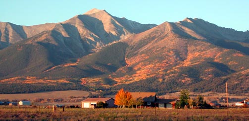
Walking this quiet town after viewing the sunrise on Mt. Yale and Mt. Princeton, I photographed the older buildings. As I motored south, I snapped photos of the Collegiate Range 14'ers, identified by highway signs. Turning off west on U.S. 50 to motor up Monarch Pass (10,312'), I found a bit more colors, then stopped at the large, pass parking area to snap pictures of Shavano and Tabeguache mountains, which I had climbed back in 1978. Life was good.
The scenery westward turned to ranchlands and lower, rolling hills. I had lots of time and was trying to enjoy it all. I came to the Black Canyon of the Gunnison National Park, and used my new park passport to save the $7 entrance fee. There are many viewpoints on the rim of this deep, long gorge, but no trails go to the bottom. The largest rock wall in Colorado, Painted Wall, is located here. I loved the clear air and overhead light. Some distant views of the San Juan Mountains to the south can be gained from the Warren Point Trail.
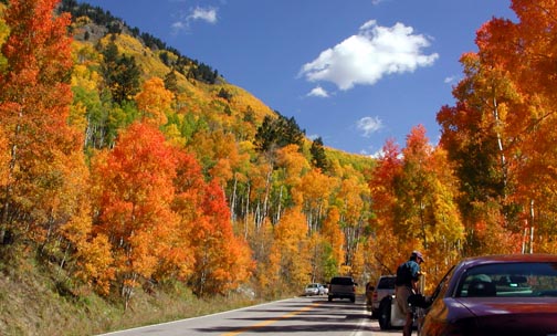
Coming to Montrose, CO, I began my auto tour on the scenic San Juan Skyway. This 232 mile loop is said to be one of the finest auto tours in the nation. I liked the views of the jagged high peaks to the south, ahead of me. My telephoto lens came in handy.
The fall colors began to appear, again,
as I motored along. I stopped for awhile In Ouray, CO, and then
at many points along this scenic highway. The colors kept on coming.
I was beginning to run out of film and memory. Silverton,
CO, made for more historic buildings, with backdrops of huge
slopes of fall color. I had been here in the winter, in February,
2002, to experience a depression of sorts, then, due to highway
closures. It is a more lively town, now. Not many of the Colorado
ski resorts seemed as big as say, Mammoth and those about Tahoe.
But, I suppose many residents just enjoy the mountains in other
ways.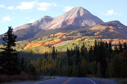
Engineer Mountain (12,972') made a fine sight. The light started getting low as I motored into Durango, CO. I got another reasonable room rate, and enjoyed another inexpensive, low fat meal. I had plenty of cash, not spending much, except for fuel.
I sought to complete my scenic loop with a drive over west to Dolores, CO. The scenic highway route then runs northeast along a river canyon, and plenty of color appeared again. I was able to record sights many California locals haven't seen or known about. There was little traffic, being a Tuesday, and I enjoyed snapping digital photos at will. CO 145 climbs to Lizard Head Pass (10,222'), with a sharp, namesake peak inviting some climbing.
Descending north toward Telluride, CO, I took the side trip into this booming ski town to walk about and snap more photos. The sky was clear blue with more gorgeous colors on the canyon slopes. High peaks tower about. Maybe someday, I will climb some of these!
I ended my San Juan Mountains scenic loop at Placerville, CO, to head for Utah. I stopped in Naturita, CO, to see some modest scenery and a busload of bicyclists. Missing a turn, I came to Uravan, CO, and noted a large industrial operation that seemed to ruin the San Miguel River. Realizing my error, I had to back track some 14 miles, and then took the right road to La Sal Junction. Paradox Valley made for a sight, then I crossed over into Utah. The south side of the La Sal Mountains was glorious with splotches of color. My 200 mm lens came in handy here.
To U. S. 191, I headed south to take the
side trip to the Needles Overlook. 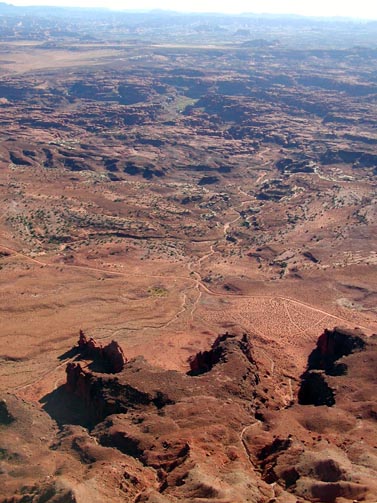 I
began to look for some camping ops, and figured I'd get some food
to save some lodging expense. The Needles Overlook, built by the
BLM, was modestly scenic, and I hiked about to get the best views.
There are no much needles, but a vast expanse of "badlands."
I savored the moment.
I
began to look for some camping ops, and figured I'd get some food
to save some lodging expense. The Needles Overlook, built by the
BLM, was modestly scenic, and I hiked about to get the best views.
There are no much needles, but a vast expanse of "badlands."
I savored the moment.
Back to U.S. 191, I headed north for Moab, UT. It was late afternoon. I sought to stay somewhere cheaply, and enjoy this fine recreation town.
As I approached the town, a car pulled out of a side road about 300 feet ahead of me. The driver slowed in the middle of the road. Slamming on my brakes, I couldn't stop in time. Wham! Was I shocked! I am a careful, safe driver, and was disturbed how my vacation would result in an accident! I was upset, but not hurt. The others were O.K., by them, and luckily, no one else hit us, as we were in the middle of a high speed highway. I collected myself, and asked the pair the personal information I needed to report an accident.
Figuring help would take some time, I pulled my car off the road. The Sheriff quickly came by, summoned by another motorist with a cell phone. The paramedics also speedily came by, and I later signed a refusal of treatment, since I felt fine. My air bag hadn't deployed, but my hard braking resulted in a long skid, so I wondered what my anti-lock brakes were for.
A Utah Highway Patrol trooper came by, and all officers were very professional. He gave me a case number for his report. Witnesses came forward to tell me the other car was clearly at fault. My front end was damaged, but I later saw my car would run fine. I was worried to no end about expenses, and now getting home. Would I have to stay for days in Moab waiting for my car to be repaired?
The road was cleared, and everyone took off. I went the 5 miles into Moab to rest and settle down. At a motel, I was able to use the phone and call the accident report number I had. Figuring my lodging here might be covered under out-of-pocket expenses, and since my headlamps were out of alignment, I had to take a room at one of the highest rates I have ever paid. Moab isn't a cheap town. I ate a late dinner, and made plans for an inspection and perhaps a repair here in town.
After a restless night, I walked up and down the main street in the early morning. Upon going to the recommended, local auto repair facility, the mechanic indicated I should be O.K. It's apparently worth it to have a solidly built auto. I then called the insurance company and I asked the claims adjuster what I should do. I was afraid of a problem on my drive home, with long stretches of desolate highway, and no services nearby. The adjuster advised, by what the mechanic said, that it sounded O.K. to drive on. So, I resolved to beeline for home.
The car ran fine, and my worry was for nothing. I have already seen most of Canyonlands and Arches National Parks on my 2000 trip, and could come back another year. Because my front headlamps were damaged, I couldn't safely drive at night. It would then take me two days to get home.
I took Highway 6 back to Provo, UT, north
on I-15 to Salt Lake City, and then west on I-80 to Nevada. Clouds
with rain had come in. Just as well, I'm going home. Lightning
struck closely about Wendover. 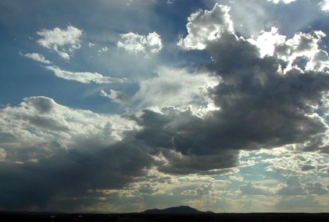 I
found the best room rates in Elko, NV. Speaking then with a Nevada
Peaks Club member living there, I got up early to have a cappuccino
with him, before he did a morning hike to a local peak that day.
I knew Lamoille Canyon would be fine for colors, but I had to
get home.
I
found the best room rates in Elko, NV. Speaking then with a Nevada
Peaks Club member living there, I got up early to have a cappuccino
with him, before he did a morning hike to a local peak that day.
I knew Lamoille Canyon would be fine for colors, but I had to
get home.
The clouds were gorgeous above I-80, and I eventlessly arrived to my driveway early in the afternoon. I again contacted the claims adjuster, and set an appointment for body work. What a relief!
Driving about 2,700 miles, I hiked only a few miles total about the towns, and never climbed a single peak. I shot some 1,700 digital images and slides. I spent about $200 in cash, and charged up five nights of lodging, all under a total of $200. My total trip fuel efficiency came to a pleasing average of 46 miles per gallon.
This is by far the best fall color viewing trip I have ever made. The colors should now come soon to California, which I may enjoy in a rental car. The Colorado "peak" was said to arrive a bit late, this year, due to "moisture," by a Denver paper, and some aspen were still green at the lower elevations. I perhaps made a hundred photo stops, with a few official viewpoints. I now know some more peaks to climb, and one day, I may yet get a good peak partner.
I may have to get more memory cards, too, as I had to reduce the image resolution as I began to run out of storage. My camera froze once, but removing the battery did reset it. I suffered some minor data loss, and one folder came up with nothing. I had a bad moment when no icon came up upon my insertion of my memory cards into my card reader. I feared I was dead, with all images lost, but replugging the USB cables did the trick.
BACK TO PETE'S THOUSAND PEAKS HOME PAGE