 The
next day, I made a short, morning, walking tour of the older part
of town, then motored over north on U.S.
97, then OR 62, to Crater
Lake National Park.
The
next day, I made a short, morning, walking tour of the older part
of town, then motored over north on U.S.
97, then OR 62, to Crater
Lake National Park.PILOT BUTTE (4,138') TWICE, AN EASTERN OREGON AND NORTH NORTHERN CALIFORNIA ROAD TRIP June 30 to July 4, 1998
To
take advantage of a holiday special and another coupon, I again
rented a '98 Buick Century to motor north to the Bend, Oregon,
area. I first drove past Mt. Shasta, onto
U.S. 97, to arrive at Klamath
Falls, OR, seeing the Museum,
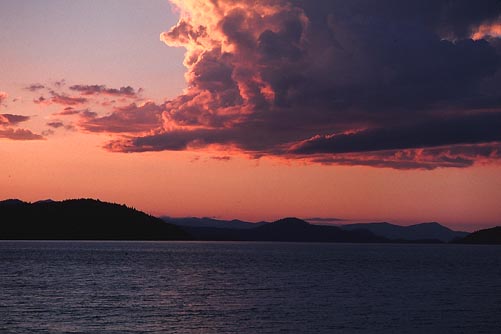
and enjoyed the sunset along the shores
of Klamath Lake. The
next day, I made a short, morning, walking tour of the older part
of town, then motored over north on U.S.
97, then OR 62, to Crater
Lake National Park.
North on OR 138, then U.S. 97, I came to Bend, OR, to get a cheap motel room. Wishing to walk a bit, I found a short hike to the top of Pilot Butte, a park within the town. Once a drive-up, a trail leads up from a large parking lot. With lots of time from the longer days, I took pictures of the sunset. It was drizzling a bit, then the most beautiful double rainbow appeared. I snapped pictures as the sunlight cast itself over the town to the east. Many of the Cascade volcanoes, from Bachelor Butte to Mt. Hood, can be seen from here. A sighting circle indicates which peak is which.
After a morning walk about Bend, I went north a bit the next day through the town of Terrebonne, OR, to see Smith Rock State Park. This is a renowned climbing area. It was overcast and then drizzling this morning, so I headed back south to tour the High Desert Museum south of Bend along U.S. 97.
The weather cleared in the afternoon, so I went back to Smith Rocks for better pictures. Diffuse sunlight made for my type of photography. Most or all the rock routes here are difficult, so I didn't choose to get a close look at any of them. Back in Bend, I hiked Pilot Butte again, but didn't get the great photography as the evening before.
Motoring back south the next day, I spent time at Lava Lands, and rode in a converted yellow school bus ($2) to the top of Lava Butte (5,016'), gaining a fair view. I next motored over to Newberry National Volcanic Monument to visit the scenic areas. I did the Obsidian Flow Trail, and saved Paulina Peak for another time.
Cruising on southeast, in the afternoon, along Highway 31, the Oregon Outback Trail, I took in the sights. This is a fairly untraveled road. I stopped at Fort Rock, Picture Rock Pass (4,830'), saw Summer Lake, and then joined U.S. 395 to view the Abert Rim. This is another classic escarpment, due to fault block geology, stretching some 20 miles.
With another nice sunset, I stayed in Lakeview, OR, to have the best (Essie
Cobb) chicken salad of the several chicken salads I ordered on
this trip. This is a good, light meal to offset the inactivity
from little hiking.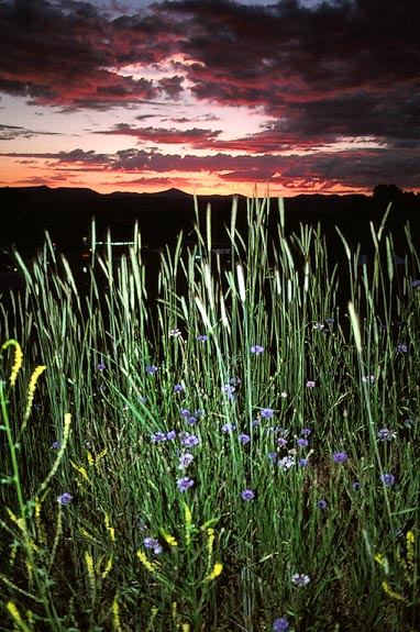 I caught a nice sunset, with some blue flowers,
from a hill with a view of the town.
I caught a nice sunset, with some blue flowers,
from a hill with a view of the town.
My final day out, I passed Goose Lake. I made a stop in Alturas, CA, then took Highway CA 299 through Pit River country. I had been curious, as usual, to see what this area looked like. I passed through the small towns of Canby, Adin, Bieber, and Fall River Mills, CA. I saw these unique views of Mt. Shasta and Lassen Peak. Rather than stay somewhere and enjoy the holiday fireworks, I headed on home.
I had driven some 1,270 miles, and did about the least hiking as I ever had done on a major drive. I shot 14 rolls of film. Despite my invitations for company, I went alone, a bit against my grain for carpooling at every opportunity.
BACK TO PETE'S THOUSAND PEAKS HOME PAGE