COLD CANYON AND PLEASANTS RIDGE
TRAIL February 29, 2004
 Loath to repeat
a hike the same season, and so close, timewise, the short drive
brought me back to this UCD preserve. I was figuring on the standard
loop, with 4 miles and 1,500' gain. I started out at 10:56 a.m.,
taking the trail to the Homestead, first.
Loath to repeat
a hike the same season, and so close, timewise, the short drive
brought me back to this UCD preserve. I was figuring on the standard
loop, with 4 miles and 1,500' gain. I started out at 10:56 a.m.,
taking the trail to the Homestead, first.
Several people were coming out, and parts
of the trail were muddy. One fellow advised me that the creek
wasn't crossable, so I went ahead to find out. Yes, the water
was high. I looked at it, then figured the dicey rock hop wasn't
worth it. Shooting a few movie clips (8.6 MB, 854 x 480, 0:46), I shortly turned around
to cancel my thought of doing this conditioner hike.
Morose, now, that I figured I'd be going
home to do what, I then came to the unsigned side trail, uphill
to the east. I haven't been up this for awhile, if much at all.
It is marked as "Pleasants Ridge Trail" on the trail
signboard map. Maybe I could get some minor gain in.
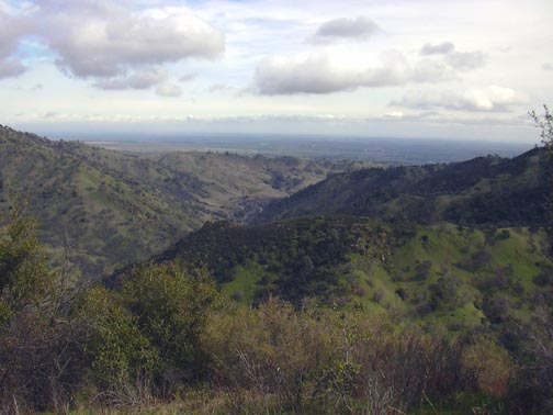
The trail goes up along a grassy ridge,
then heads straight up the steep ridge. I gained views upstream
of Cold Canyon. Dark clouds were forming, and I assumed the rain
predicted for this night was coming in early. I'd say parts of
the trail approached class 2, with rock steps and rubbly parts
which could get slippery in a good rain.
I fixated on the hill above me, and knew
that the distance wasn't long. Gnarled, but still bare-leafed,
oaks graced this hill, and views began to get good. The Lake Berryessa
dam was right behind while going up, and soon I came to a small
knoll. The view down to the resort and Putah Creek was nice.
Too soon to end this hike, I continued
upward to another hill. This took me some 50 minutes from the
bottom. There by 12:19 p.m., I took in the view. This was a worthwhile
short climb! The view of the Central Valley was a good reward.
The clouds made the light diffuse. I drank up my water, and looked
about for a register. None to be found. The trail might continue
to another high bump, but the ridge over there looked rocky. Fearful
of some rain, I started down at 12:33 p.m.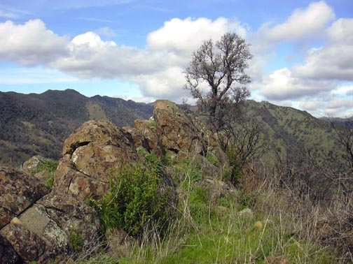
Parts of this trail are for the agile only.
I came back to the first knoll for a photo of the rocks and the
gnarled oak at its top. I stepped down slowly, and I might easily
be heard yelling, should I have an unfortunate slip and break
a leg.
Back to my car by 1:06 p.m., I saw my worries
were needless, and that I should have continued to the top of
this ridge hike. I had also nearly used up my memory card, mostly
wasted on "use-it-up" pictures of the trails and the
creek.
I figured I did some 2.5 miles with 1,000'
gain, round trip, total. I shot 91 items, with a few movie clips
of the creek. I need to get a better winter conditioner hike.
Fiske was perhaps unreachable since the low water bridge might
be flooded, and I tire of the 200 mile drive, round trip, to Mt.
St. Helena.
A few flowers were blooming, with shooting
stars and brodiaea. Some paintbrush were at the top of the ridge
hike. I also spotted many tiny white, yellow, pink, and blue flowers.
Just not the right light, though, for any good photos.
BACK TO PETE'S THOUSAND
PEAKS HOME PAGE