RENO HILL WALKING November 19-20,
2000
Badly
in need of exercise, I sought to do some short conditioning hikes
about the Truckee Meadows. 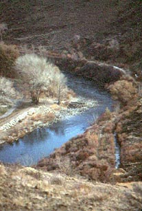 After
a highly disappointing view of low,
backcountry snow conditions along Interstate 80, I stopped by
the Patagonia Outlet to hike the Tom Cooke Trail and the small
hill to the south, all over the Truckee River bridge here. This
short, switchbacking trail offers a view of the snowy, northern
slopes of the Mt. Rose massif, and the mostly bare slopes of Peavine
Peak to the north. In the photo right, the Truckee River flows
placidly.
After
a highly disappointing view of low,
backcountry snow conditions along Interstate 80, I stopped by
the Patagonia Outlet to hike the Tom Cooke Trail and the small
hill to the south, all over the Truckee River bridge here. This
short, switchbacking trail offers a view of the snowy, northern
slopes of the Mt. Rose massif, and the mostly bare slopes of Peavine
Peak to the north. In the photo right, the Truckee River flows
placidly.
Driving clockwise along McCarran Boulevard,
I checked Keystone Canyon and the Evans Creek area for some hiking
and pictures. Getting to the big "R" and also "N"
have been stated to be good hikes.
After checking into a room at a major downtown
casino complex, I motored over to East McCarran and the end of
Pembroke Drive, where a sign marks
the "Truckee Trail...California Trail." A dirt road
leads steeply up into the range here. I was able to get 40 minutes
of good, uphill conditioning.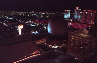
Back to the casino after
dusk, I enjoyed a $10 prime rib dinner, and then plenty of
entertainment.
The next day, I first checked the summit
dirt road, from Stead Boulevard Exit, up Peavine Peak. It appeared
that snow would cover the upper portions of this road, judging
from the coverage that could be seen. I had done a hike to the
top last year at about this time, which was nice, dry, pleasant
conditioning, with the local Sierra Club.
Motoring a bit north, I found a dirt summit
road to the top of Granite Hills (6,031'). Red Rock Exit off U.S.
395 leads to Wells Fargo Road, then a left on Silver Spur Drive
goes to a parking circle in a quiet residential neighborhood.
It took me 43 minutes to hike the thousand foot gain to the rocky
summit. Powdery snow made for some interest, covering the road
at points. The view was nice, with
Silver Lake, a watered flat, below to the southeast. The interior
ranges were either bare or white, by their elevation.
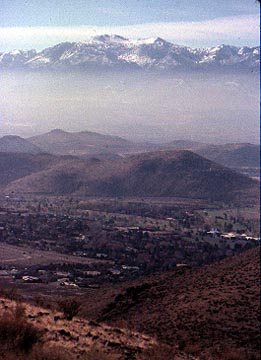 For
more exercise, I motored back to Pembroke Drive where I completed
my peak workout attempted the afternoon before. I saw coyotes
and wild horses enroute to the local summit
(5,980+'). A good view of the Interstate and the snowy ranges
to the south were had. Mt. Rose (in the photo left) rose above
Rattlesnake Mountain. Peak 5,980+ took me some hour and fifteen
minutes to top out, and then about an hour to hike down.
For
more exercise, I motored back to Pembroke Drive where I completed
my peak workout attempted the afternoon before. I saw coyotes
and wild horses enroute to the local summit
(5,980+'). A good view of the Interstate and the snowy ranges
to the south were had. Mt. Rose (in the photo left) rose above
Rattlesnake Mountain. Peak 5,980+ took me some hour and fifteen
minutes to top out, and then about an hour to hike down.
This area was said to be private land,
but was not posted. A "Hidden Valley Park" lies to the
south a bit. Another peak-bump there, about as high, makes for
another good conditioning goal.
After food, drink, and a visit to the local
library, I quickly zoomed home. My total stats were, roughly,
some 4,000 feet of gain, and fourteen miles hiking.
BACK TO PETE'S
THOUSAND PEAKS HOME PAGE