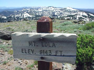
MT. LOLA (9,143') 5X, RELAY PEAK (10,338') June 30-July 1, 2002
Timing this trip right to obtain a highly favorable room rate, and the changing of weekly specials at my favorite outdoor clothing outlet, I knew I would do these repeat ascents, planning Mt. Lola and Mt. Rose, so routinely. But, I hoped to see what was new about my corner of the Sierra.
Having some doubts about my peaks guide
description of the approach to the Mt. Lola Trailhead, I took
notes once again, and found most everything was the same. However,
the approach dirt road to the trailhead, after crossing the one
lane bridge, was marked by a "road closed" sign. I recollected
this sign the last time I sought to make a check. It seemed to
read, closed "2" miles ahead, but looking closely, there
was a dark tape placed along the original number, a "7,"
to make it read, "2." I would have no idea whether this
was done by the USFS, or a prankster. The total distance to the
trailhead from the paved road is 4 miles exactly, so one might
infer that the trailhead was not accessible, then.
Taking a hunch, I motored past the "road closed" sign to check it out. My directions are still good, although new signs had been placed, with perhaps some other minor changes. I asked a passing gentleman in a 4WD about the road and trailhead, and he said it was O.K.
Some mosquito repellant and sunscreen were needed today. Starting up the trail at 9:55 a.m., I enjoyed hiking up the forested Cold Stream Canyon, and the stream was flowing well. Keeping notes on the route, I saw some timber cutting that led me to decline a route doing the Sierra County Highpoint, "North Lola (8,842')." The cross-country route down from this point straight back east to the trail would take me through this mess.
Encountering snow from about 8,000 feet elevation, I was able to follow the trail, but at one point had to look for it. I know where the trail runs, so I gained the ridge, and crossed more snow to get to the top. Summiting at 12:30 p.m., I enjoyed the views, and noted the larger amounts of snow on the northerly slopes to the south.
The register needed a new book, so I obliged. I headed down at 1:24 p.m., and a hiker appeared and asked for "water tablets." Not having any, I suggested to mix clean snow with any water in their canteens, and then also expecting maybe to hear they were lost, decided to leave them to their own graces.
I had some fun, as later this weekend, doing short standing glissades on the snow fields and patches. Coming back to the dirt road that parallels the trail, I saw a pick-up truck, then an ATV. I inquired about this dirt road, as I knew many hikers with 4WDs would like to know this route. If the road is taken to its end, that would save some 1,000' gain, and maybe 2.5 miles each way. It doesn't appear on any of my maps.
It took me another hour to get back to my car, and I shortly motored off with plenty of time to check in at my hotel. Stopping for gas, and doing some quick shopping, I came into the hotel reception desk and got my room on the 26th floor.
Consuming a light meal at a casino restaurant,
I enjoyed the ambience, and then the sunset from my window view.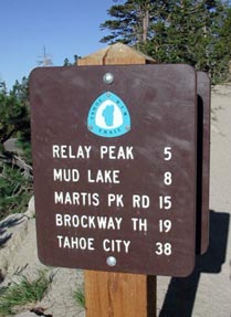
Checking out early, on Monday, I motored up to the Mt. Rose trailhead, and started my hike here at 7:40 a.m. The heat was building up already, so I opted to forgo my 10X on Rose, and hike this new section of the Tahoe Rim Trail. New signs were up, and I first climbed to the communications complex on the top of one 10,000 foot peak. I was able to climb a smaller tower via the staircase, and took pictures of the view.
Backtracking a short way, I followed the Rim Trail, which passes the summit of Relay Peak by a few feet. I pondered over placing a register, then continued on to follow the Rim Trail downward and westward.
There is some good rock work, and the trail
is fine. I had to cross a few snowfields, no problem for an experienced
hiker. Losing maybe a thousand feet elevation, I saw the trail
continue to descend past a group of rock crags, so I turned around
and climbed back up to Relay Peak.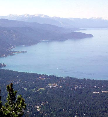
Regaining this summit, I watched two gliders circle above. I then chose to put a small register, and maybe check it next year when I would need to get some exercise again.
Getting back to my car by 3:03 p.m., I motored back into Reno and took I-80 west to more shopping. I pondered on a short climb of Donner Peak, but will forgo that till when I do my "Grand Slam 4X."
I had hiked some 24 miles with 5,200' gain total. I shot some 300 digital images and movie clips. I spent some $40 cash, and after the $30 for the hotel room and part of dinner, charged up some $100 for new clothes, and a replacement logo water bottle, all with highly environmentally friendly manufacture.
There were some old snow plants along the Lola trail, and many flowers were in bloom. Lupine, paintbrush, wall flowers, mule ears, pennyroyal, columbine, and some blue flowers made appearances, and I especially liked the large, fine, mountain hemlock along the TRT.
BACK TO PETE'S THOUSAND PEAKS HOME PAGE