 Backpacks are unusual for DPS climbs. This one was
necessary to make a more enjoyable weekend for this prominent
Death Valley National Park peak. Rich and I were to do two more
peaks while down here.
Backpacks are unusual for DPS climbs. This one was
necessary to make a more enjoyable weekend for this prominent
Death Valley National Park peak. Rich and I were to do two more
peaks while down here.SENTINEL PEAK (9,634'), PORTER PEAK (9,101'), AND NELSON RANGE HIGHPOINT (7,696') April 22-24, 1995
Backpacks are unusual for DPS climbs. This one was
necessary to make a more enjoyable weekend for this prominent
Death Valley National Park peak. Rich and I were to do two more
peaks while down here.
We had a scenic drive south along U.S. 395, with beautiful snowy peaks and then other sights. We met in Ballarat, a real colorful scene, in a less visited part of the new Park.
Motoring a short way to the trailhead for Surprise Canyon, we parked and readied for the carry to Panamint City, an abandoned town six miles up this canyon. A short walk along a running creek leads to a class 3 waterfall, which we all easily did. The route then follows the dirt road, washed out in the narrows, by a massive flash flood years ago. This leads up canyon to the collection of buildings that was to make our camp. Dirt bikes are still allowed on this road, with three to give us company. They have to be hauled over the class 3 section. It is amazing what off-roaders will do to get their machines to their destinations.
We took over the best building, replete with rooms, bedrooms, and bathrooms (nothing working). The dinner plan had been for everyone to carry in an item for a salad. I brought broccoli and artichoke hearts. We dined in civilized style, with chairs and tables. I took a spot to sleep out on the porch, with a sunset casting red light on the peaks to the east.
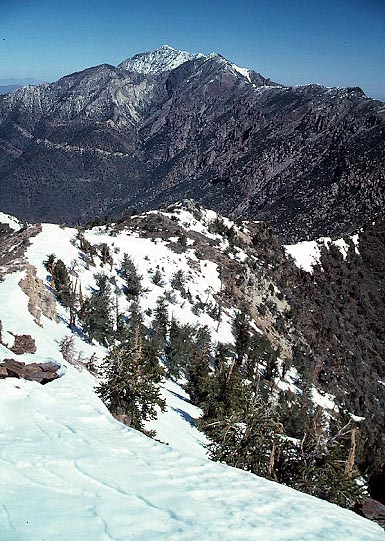
Hiking early the next morning, we followed the road briefly, then climbed cross-country up the northern slopes of Sentinel Peak. It is a longer climb, and we ran into good patches of snow. Telescope Peak, to the north, stood over us as we ascended up the final slopes.
We spent some time on the summit, then quickly hiked back down. I wasn't looking forward to the backpack out. The pack weight has begun to adversely affect me, after so many day climbs with a lighter pack.
We made sufficient time back to the cars, then we parted ways with the DPS group. The stats for just this peak alone total over 7,000' gain, with a total of 16 miles round trip, by the DPS Guide.
Staying in this abandoned town, Panamint City, proved a sort of unique, ghost town camping experience that many might enjoy.
Not done yet, Rich and I motored around to a road climbing high on Porter Peak. Many trips have been run doing a traverse to Porter from Sentinel Peak. However, this high road, not then described in any guide, saves us plenty of hiking. From our 8,000' elevation car camp, it was only a couple miles and about 1,000' gain for Porter. While having no flat place to sleep, I knew there wasn't a great need for a real good rest, given the easy climb the next day.
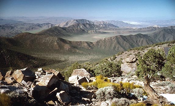 We
did the peak in short time. The view
was typical high desert here. Motoring back down to the Panamint
Valley, we drove north to CA 190, then north again to the
roadhead for the highpoint of the Nelson Range. Our vehicle made
short work of the last mile of rough road, and we chose to make
the hike this same day, with enough daylight this time of the
year.
We
did the peak in short time. The view
was typical high desert here. Motoring back down to the Panamint
Valley, we drove north to CA 190, then north again to the
roadhead for the highpoint of the Nelson Range. Our vehicle made
short work of the last mile of rough road, and we chose to make
the hike this same day, with enough daylight this time of the
year.
I found a use trail, not described, to make the short climb even faster. This leads toward the peak, then a cross-country route leads past a snag with a view of the nearby Inyo Range. I was willing to make my second ascent since this is no great strain or hardship, with only again a few miles with about a thousand feet gain.
The summit view looks straight down the Saline Valley, and the register marks the true highpoint. We finished with these climbs early enough that day to take another long drive home along U.S. 395.
BACK TO PETE'S THOUSAND PEAKS HOME PAGE