McCULLOUGH MOUNTAIN (7,026') AND SPIRIT MOUNTAIN (5,639'), PLUS ANOTHER DESERT EXPLORATORY February 21-24, 1997
Leaving a bit early before the weekend, I stayed in Barstow. Getting up late, I drove east to the route CA 127, where I took many pictures of this scenic highway. I then stopped briefly at Nipton, CA, before motoring over to spend some time in Searchlight, NV. Driving back west along the Joshua Tree Highway, NV 164, I camped at about our road meeting place to be joined by a couple of the participants and leaders. A rising, nearly full moon made for a sundown photo op.
The morning of the climb, we were led in
our cars up a maze of dirt roads, to check this way and that way.
The DPS guide seemed somewhat deficient for this eastern approach.
The leader decided to go by another route, which meant we had
to leave out a non-climber, and go way around the range to its
west side.
Taking I-15 to Primm, NV, we passed by the casinos and took an improbable dirt road into a terribly used ORV area. I wouldn't have believed, with the dust and damage to the earth, that users would like doing this. I had great doubt in going by this way, fearing that we would only get stuck in the many mounds of churned up soil.
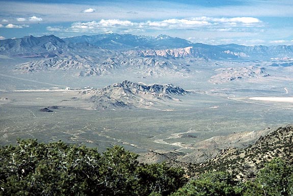
However, with the excellent driving of the group, we came to our roadhead and the cabin that marks the start of this hike. The peak is only a three hour round trip, since the gain and distance are less this way. We made a fast hike to the top, gaining a nice view to the west, including the Spring Mountains and Jean, NV.
Staying only as long as we had time for, we made a descent in about an hour. Driving out into the sunset on these atrocious roads, we came around back to the left-behind camper, then all drove over to have dinner in Searchlight, NV.
A car camp by Christmas Tree Pass in the Spirit Mountains allowed for a brief conversation by flashlight, then we had a glorious sunrise for our climb of Spirit Mountain.
The climb requires a small vertical loss
in elevation, and following some faint use trails. The leader
knew a very good route, picked only by an experienced person.
I recall that a local chapter group had thrashed about, taking
much longer for an ascent than our total round trip.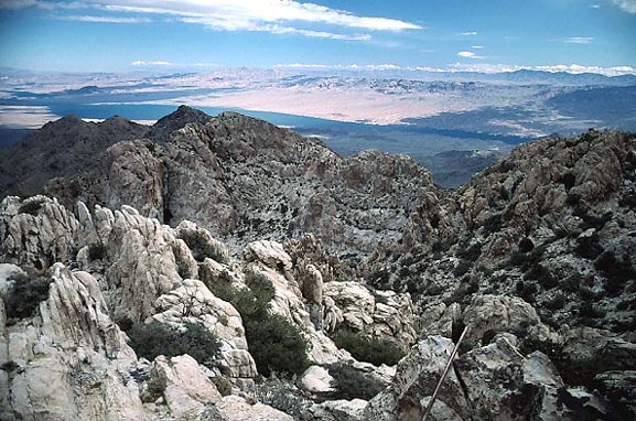
Climbing up rugged terrain, we had no big delays, and shortly gained the summit ridge, then topped out with grand views. Lake Mohave was off in the distance (photo right). Being a bit cold and windy, the air was clearer, and the new resort of Laughlin, NV, was visible to the southeast.
We made an expedient return for everyone else's long drive home. Our round trip hiking time was under five hours. I continued east on the Christmas Tree Pass road to Grapevine Canyon, which is a developed BLM petroglyphs site. I enjoyed being on my own, taking photos, and hiking about the rocks.
I wanted to see Laughlin, so motored through, and inquired about lodging. The trick is to make a reservation early to get the bargain rates. Disappointed, I motored south toward I-40 to see an incredibly cheap room rate at another lone casino, run by the Fort Mojave tribe. I pulled in, and took it.
The next morning, I drove east up AZ 68 past interesting scenery to visit Arizona. Passing through Kingman, AZ, I motored up to Hualapai Mountain Park, seeking another peak hike. Snow covered much of the trail and I just took a picture. I will have to return someday to climb the peaks in this area.
Touring a museum back in Kingman, I drove north on U.S. 95, snapping pictures of the ranges and peaks. I made a short detour to the town of Chloride, AZ. This has some potential for a point of interest, with decaying buildings so typical of a ghost town.
Crossing over Hoover Dam, I still had plenty of time to auto tour. Coming to Las Vegas, I was amazed at the size of this town. The population was said to have surpassed one million.
I took a quick late lunch, then motored to Valley of Fire State Park, about 40 miles east along I-15. The skies were a bit cloudy, but I snapped pictures of the occasional breaks of light on the beautiful red rocks. I stayed till about sunset, then drove back to Las Vegas, hoping to get some cheaper lodging.
Parking at a casino lot, I walked over to Fremont Street, which was the site of a then, major, downtown redevelopment. I used faster film for some photos of the neon, and briefly enjoyed the now closed-off street. A huge canopy encloses the street, turning it into a pedestrian mall.
Leaving at about 7 p.m., I sought to get lodging and food in Stateline, NV, but the buffets were closed as I got there. I made an all-night drive home to avoid, what were for me, the steep lodging rates most everywhere.
BACK TO PETE'S THOUSAND PEAKS HOME PAGE