UNDER CONSTRUCTION
TAHOE HIKES 2X October 13, 2014
 Never now with ever a partner, I figured on doing a shorter road trip. I had been gaining weight, dining well, and despite my apps to help with walking about town, they seemed to show more miles than I actually had walked. My hiking app is stupid, unable to tell if I had been riding in a car. It seemed that I had cured some issue with the device barometer by a software restore, but it counts gain as flights of stairs, not as feet or meters of elevation gain.
With mountain fall colors showing online as peak or past peak, I’d seek to do some video as I drove. The June Lake Loop is especially pretty in the fall, and once I had tried to record the drive through magnificent aspen groves, but failed. Room rates were high in Mammoth Lakes, CA, so I first figured to do the drive down U.S. 395, to June Lake, and back through Yosemite, in a day. Having driven a 900 mile day, not many years ago, this’d be fun.
Up early Monday, I wondered whether to do this. The forecast was good to Wednesday, so I had two days. I figured to make reservations on the fly if I decided to do that, so I left home by about 6:15 a.m. Setting my dash cam, I was still fearful of some slip, and getting into an accident. My mind isn’t as sharp as it used to be, and I can see from my old peak buddy that senility does happen, and he gets into accidents all of the time.
As I motored eastbound on U.S. 50, I began to get drowsy. I decided to skip all this, and headed for Kalithea Park to capture the dawn glow, by a time lapse video. There in time to get the sunlight creeping across the scene, I took photos of the sunrise and clouds in the other direction. Speaking with my peak buddy, he wasn’t interested, as usual, in riding along on a big loop for the day, preferring to have his car maintenance. Going to a nearby fast food eatery, I drank plenty of diet soda, which helped. So, instead of going straight home, I’d head for South Lake Tahoe. I could lodge there, and complete the loop the next day.
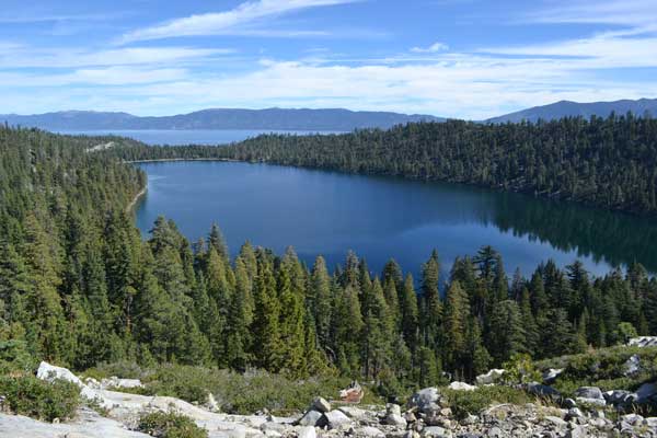
 Motoring east again, I skipped a stop at the ranger station, and made it to Taylor Creek visitor center. Doing the Rainbow Trail once again, I saw that it was indeed past peak, here. The Kokanee salmon made for video, and a sign said that due to the drought, there would be less fish. Ducks floated about, apparently consuming the eggs, and I wandered along the trail, with holiday crowds.
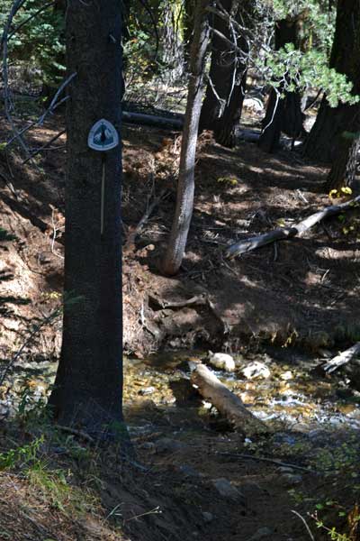
Next was to hike to Cascade Falls, which I haven’t ever seen. Parking at the Bayview Trailhead, a sign stated the campground would be closed, and the gate shut, at 12:30 p.m. I had a bit over an hour to do my hike, so off I went. Rushing along, other hikers didn’t seem to have any urgency. Cars filled the parking, and I presumed they’d be locked in. A couple trail crews stopped work to let me pass, and I feared of a stumble or trip. It isn’t that far to the falls, but I looked for them at the crossing of a creek. Asking a person, she said that they were down a bit, and not running much. I just wanted to say that I had been there. Going back, I saw a trail sign at a junction that I had missed. Choosing to skip it, I hurried back to avoid being trapped by a gate closure. Making it out of the campground by 10 minutes to spare, I’ll try to return when the falls are going better.
Having perspired a lot, I went to the fast food for plenty of drink and a snack. Nice in the sun, I took my time, surfing on my device. I sought to do another easy hike, with plenty of day left. Finding a Becker Peak by Echo Lakes that I haven’t climbed, I sought to get the directions. Most people had done it on snow, and I wasn’t that sure that there is a trail. My downloaded topo map didn’t show any trail, but I recalled that there was an old one.
Motoring back west on U.S. 50, there was road work, and nobody seemed to notice that they were being recorded. Though I was exposed to porn by the hiking club peak chair, with his massive collection, few think much of it, nowadays. That I have footage of people unbeknownst to them, doesn’t excite me. The news about password breaches and private photos is all in the normal course of events. Some people like being seen, and shown to the world. Starlets have gone from unknowns to quite famous, due to nude photos. While many in the old hiking club were induced to doff all, and with their hidden photographers clicking away, I was attacked for pictures of peaks!
Taking the Johnson Cutoff road, I came to Echo Lakes parking by the chalet. I had to use the facility, though I brought my pee bottle. Driving back up to the main parking lot, I started my hike. Hiking the Pacific Crest Trail southbound, it appeared to cross over the ridge that leads to Becker Peak, so I’d watch for a use trail. I set my hiking app, but it isn’t very accurate. Other hiking web masters show routes on maps of their adventures, but they use GPS devices, and now, I have better and cheaper. Used to be those ran much more than my latest device!
Hiking upward, I looked, but saw no use trail. Deciding to just hike with no peak today, I reminisced about my backpack trips when I was young, hiking every foot from Whitney Portal to Meeks Bay, Lake Tahoe. There hadn’t been any PCT back then, so I enjoyed doing this section, taking lots of pictures.
The trail descends downward, so there isn’t any obvious use trail to the peak. I knew the PCT goes to U.S. 50, and I had to use a facility. There was a creek crossing with a log, but I hopped on rocks to make it across safely with my electronics. Going over the Echo Lakes road, it shortly comes to U.S. 50., and I did a panorama to mark the crossing.
 Hiking back to the lakes road, I headed east to get to the Sno-Park and the outhouse, which was gratefully unlocked. Taking the road back to the hiker parking lot, it was now right to start heading home. June Lake would be likely past peak, as Conway Summit, and the lodging would cost $40 in Carson City or SLT. I seem to like webwork, as much as hiking and travel, and a major software upgrade was due for this week. What cost other people in the past, I will get for free!
The sun lay in the sky ahead as I motored home, and I was concerned about fire, or even an explosion, due to the sensors being heated by the sun’s rays through the lens. In other cameras, you do not point the camera at the sun! Clouds may have diffused the light, and I was too late going by the ranger station to make any trail report or have any discussion. Passing Camino, I saw a sign, so took the Apple Hill scenic road. I set my camera, as this is scenic enough, and of some interest to non-hikers. I didn’t stop for apples, as I prefer blueberries myself, but the short loop was a video coup.
Back to the freeway, I did a loop through downtown Placerville, too, and it remains to be seen whether I can ever edit the dash cam video to correct the color. The sun was still high in the sky ahead, so I went to the casino to have some soup, and then to try a bit of cards. Learning a new game variation, I won a slight bit, but gave it to the helpful dealer as a tip. The free Wi-Fi here is fast enough to view the online TV HD news on my ancient handheld. Never was the technology as it is, today!
The sun had already set as I motored again on the freeway, but I enjoyed what will be nice footage from this trip, to share with the world. Dusk magic hour set as I motored down the hill, and I didn’t waste my time calling my old peak buddy. Claiming he can’t get up fast enough from his chair as the phone rings, I constantly advise him of the cheap technology available years ago, whereby he can run a cable to a $5 phone extension that can be placed right by where he sits watching TV. Miser, moron, 1950’s to the end. A Ph.D. The hiking club is filled with dimwits.
Coming home after another quick stop for food, I got to the downloads, and settling in for the week. I had done some 4 miles, estimating from my app measurements, being that they are about 50% in excess. It said “12” flights of stairs, but I take that as being some 250 feet, total. Driving 232 miles, I spent about $30 cash, and used the $20 worth of fuel, purchased at 3.299. Capturing 330 images and movie clips, with several lengths of video by my dash cam, I’ll be working on my website for awhile, as the High Sierra fall color season, I deem, is about over.
It will be nice to return to Yosemite Valley for the fall colors, there, and to enjoy the freebie, with now my Senior Pass, and also other discounts with age. The new challenge is to survive Ebola, with the virus spreading, and perhaps soon to be everywhere. Grim scenarios presented by Hollywood movies do cause me to be fearful. To move to a south seas island may delay the inevitable, but as my peak buddy and I discussed, a good immune system, with healthy habits, good sanitation practices, and luck, may see us through!
BACK TO PETE'S THOUSAND PEAKS HOME PAGE