June 9, 2013: U.S. 20 east to Cody, WY, WY 120 south to Thermopolis Hot Springs State Park, WY 789 south, Riverton and Lander, WY, Sinks Canyon State Park, U.S. 287 to Dubois, WY
Up early again, I had been in my car seat in my sleeping bag, with medium coolness, no hat or gloves at night needed. No frost, condensation, or anything as in the Sierra high country, say. I enjoyed having the slow connection, but could hardly wait to get back to a good motel.
 Leaving then the campground in the early a.m., I headed south on the park roads, and passed by Fishing Bridge on U.S. 20. I snapped some photos with my flash, and descended on good highway in the dark. No animals in the roadway, as I was mindful of driving too fast. I may have to come back to see the views, but I can now say that I have driven all of the major Yellowstone highways.
The drive east in the dark went fine, and finally, I was passing cliffs and a canyon at Buffalo Bill State Park in the early morning light. Another sight to see in the daytime, someday. I came into Cody, WY, and sought breakfast. I shot some street scenes, and waited at the fast food eatery for them to open. I had my muffin sandwich and caffeine, then motored on in the dawn light.
Taking WY 120 south, I wished to make a short jaunt out over two more passes in the Rockies for another list completion, a future bucket list goal, with more passes to drive in New Mexico, and Colorado, someday. I thought of a stay at the economy chain motel in Riverton, but it was too much for me at over $60/night.
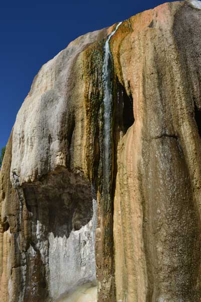
Coming then to Thermopolis, WY, I had some time with a sight to see. The world’s largest mineral hot springs awaited to visit, here. I stopped in town by a mural for the dinosaur museum, and got my directions. Coming then to the state park, I went under a bridge and to the main parking lot, and then to the first hot spring for information. The park is free, but they charge for hot springs use. I was allowed to test the water in the indoor pool, and it was tepid, and I may like to return in winter, say, when it is more popular. I got drink, and did a short walk past some formations and then over a bridge on the Bighorn River.
Doing video, I crossed the swinging bridge, and went to a viewpoint, with some flowers. Completing a loop, I used one of the convenient restrooms, and took some telephotos of the other sights.
I had some driving to do, taking then U.S. 20 further south past the Boysen Reservoir, with a photo stop. Shoshoni made for a break, and then I took WY 789 south to Riverton, WY. I took another break with food and drink, then went by a Walgreens for ATM cash. A long main street, with services.
Now, it was to WY 789 south again. There were sights ahead, and then I made an impulse stop at the Wind River Casino to seek rates for lodging. Asking, they said $80 for a room. I thought about food, but signs disallowed cameras. I didn’t wish to not be able to take a photo of my food, so left. Attractive females, though, and I had thoughts.
Going on to Lander, WY, I parked on the main street in the center of town, and went to a coffee shop. Food here was fine, and I was refreshed. By the street, there is the NOLS headquarters, so I went by to take a look. In a historic hotel, there were displays of history and the use for outdoor rec, now. This is a gateway to the Wind River Range, an immense wilderness, and also the highest point of the State of Wyoming, Gannett Peak. Long ago, I sought to climb this summit, but never could get any partners. It necessitates crossing a glacier, so ropes and teamwork are needed for safety. Some locals have claimed to have done it, but with no good photo vistas from the top. I post the views from all of my peak conquests, but for others in the old hiking club, that gets zero priority. Once they did advise of not leaving a paper or even a film trail, as then otherwise, say, if you failed to achieve a summit, you then wouldn’t be able to claim it, as then, where would be the photos?
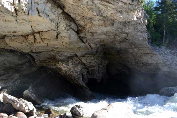 Finding the way to Sinks Canyon State Park, I sought a visit to this wonderful feature. The river here flows under a cave, with two parking lots. I came to the first, lower one, an outlet for the water gushing from a spring, with large fish in the river. To the upper second, with a visitor center, I took the short walk to an overlook, then down to the river cave mouth. A huge flow of roaring water entered into the underground cavern, and it was quite a sight. I did my photos and video, and some of this water disappears into some aquifer unknown, as the outflow does not match the inflow.
Checking the campground, it was late in the day, and I had to stay somewhere. It didn’t look too appealing, so I left to go back into Lander. I motored northwards on U.S. 287, with a stop at the Shoshone Rose Casino for a break and some gambling. I won a dollar, and used the restroom.
Seeing a sign, I detoured to see the supposed final resting place of Sacagawea, the Native American maiden who had helped lead the Lewis and Clark Expedition, the 1804-06 Corps of Discovery. There was a cemetary, and I looked about, taking pictures, but failed to discern the grave. There is dispute on her fate, and she is depicted on a coin, but by an artist’s rendering, some speculation, as no photos exist of her. If any facial remains can be accessed, I suppose the looks can be reconstructed by computer, but with no DNA or other identification, who knows if some skull is really her?
Coming then to U.S. 26 after sights ahead, I headed west to Dubois. Tired, I came to a RV park, and took a site. For under $20, I slept in my car again, having drink and a restroom right nearby. I used my 4G for some surfing, and managed to doze off.
Summary, 30, 31, 1, 2, 3, 4, 5, 6, 7, 8, 9, 10, 11, 12, 13, Movies
BACK TO PETE'S
THOUSAND PEAKS HOME PAGE