THUNDER MOUNTAIN (9,408’ and 9,410’) 4X July 10, 2012
 Still needing to try to lose some weight, I also wished to escape the heat and avoid being stuck indoors with a high predicted to be 106. I decided not to do a road trip, so far, and the local peaks loomed for a quick, cheap adventure. The trail to the top of Thunder Mountain had not been built till about fifteen years ago, so I have not hiked it very much. I’d do an update and check for my peaks guide.
Taking U.S. 50 east, I stopped in Placerville, CA, for drink and food. The Mormon-Emigrant Road makes for a good way to get to Highway 88. I made a stop at Shot Rock vista for a rest and photos, then motored east to the Thunder Mountain Trailhead. Getting there at about 10 a.m., I managed to start hiking at 10:17 a.m.
It wasn’t yet warm, and a few mosquitoes were out. I had applied sunscreen, knowing that I’d have a full day at altitude. I took photos and video of the snow deflectors, and enjoyed the light uphill on this trail today. They had built some new trails, and I came to a junction with a trail headed down to Kirkwood. There seems to be a new trail out towards Thimble Peak, too. I had my fun with video and photos, and the wildflower show was alright.
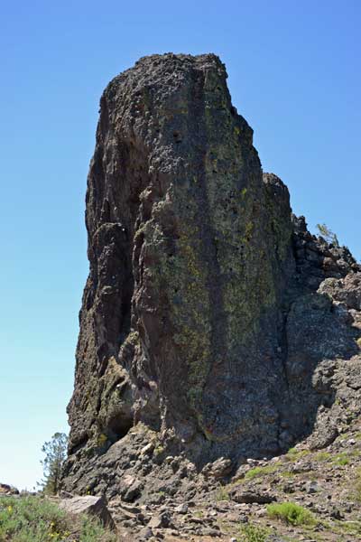
Thinking they had rerouted the trail, I seem to have some failing memory. I hiked on along the top of a ridge, and anticipated the high summit ridge, and the short hike to the top of the highest peak, 9,410’. This is the highpoint of Amador County. Gaining the notch, I seem to have underestimated the distance to a use trail. I scrambled up on steep rubbly dirt, then found the use trail. It leads up through some rocks, but I see that some people are interested in this peak.
Topping out at 12:33 p.m., I started with my 360, then more photos. Drinking water, I saw no register. I enjoyed resting alone, and noted a group of people over on the lower summit, 9,408’. I did some video, and then figured to get moving again.
Running into two hikers asking, “Are we there yet?,” I inquired about their goal. Informing them about the highest peak, I headed on for the lower summit. Some quite young children had been hiking this lower peak, and I was impressed. Scrambling along the rocky trail, I soon reached the top at 2:01 p.m..
I did another 360, then more photos and video. There is a taped up jar to hold the register. I haven’t been here for 8 years, so my book was long gone. I am retired from register placement, but two books weren’t filled, so I signed in. A few names that I recognized.
A cute chipmunk came around, and I shot some video. Those other two hikers appeared on the trail, shouting about what there was on this summit. They were interested in signing into the register. One of them came up to this airy summit, and signed herself in. She handed down the book to her friend, who wasn’t so game in reaching the top. Only a matter of feet, I mentioned that this was “cheating,” but the old peak club was notorious for claiming what they do not do. Better to have liars or exaggerators than numerous dead or injured people about the Sierra, having then to be rescued, all because of having to climb the peaks! I am seeing myself, in my aging ability, that you get more prone to accident when you get older.
 Another hiker came up, and we chatted a bit. He wasn’t interested in signing in. Many entries were from young people, as I find it great to see your name still up there maybe years from now, ideally. I began down at 3:19 p.m., taking photos of the rocky trail with some slight scrambling required in spots.
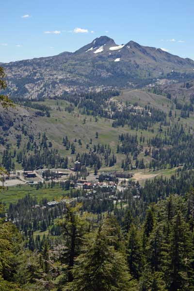
Using caution, I went slowly down the trail, doing more video, and enjoying the cool breeze. It must be awful hot in the Valley. Resting on the top of a rise, I wondered about my estimate of how much the trail dips on the ascent. The views of Kirkwood remained good, and people down below can keep visual track of hikers on the trail in spots. The last hiker passed me going down, and I sped up my pace as the trail got less rocky and steep. I fretted a bit about some freak mishap, but reached the car at 5:30 p.m. Here, it was warm.
Motoring off, I took a detour to Kit Carson Lodge to get a cold drink, then check for dinner. Parking is scarce, so I left. I took the road back to U.S. 50, and had a light meal at the casino. The sun was setting as I came out of the garage, then my camera battery depleted as I drove down the hill during magic hour.
Home safely, I hiked 7.2 miles with 1,800 feet of gain. I captured 412 images and movie clips (366.7 MB, 12:40, 720p HD). Spending about $21, I had about a half tank of gas as I left home, and came back empty. The drive was about 195 miles round trip.
The city high was lower than the radio said, so I imagine that I may stay in town for awhile. I’ll be working on my website, and that takes a couple days or so. It is due to cool down, so there is relief. I am adjusted to walking in the cooler morning, so I will be fine for exercise. It’s a matter of refraining from eating too much!
BACK TO PETE'S
THOUSAND PEAKS HOME PAGE