HORSETAIL FALLS AND EAGLE FALLS June 14-15, 2011
 Weakened by inactivity due to various factors, I figured to start my summer by doing some easy hiking. Higher snowpack and elevated temperatures for these two days induced me to leave town to witness the runoff. I also found a low room rate on lodging, so chose to make this an overnight trip.
Highs were to reach 100 degrees in some Central Valley locales Tuesday, but I just knew this would be the prime time for snowmelt. Tioga Pass was still closed, so I was unable to combine a visit to Yosemite Valley with a jaunt to Lake Tahoe. I slept late and left home by about Noon, with only a short hike and drive to do.
Traffic wasn't too bad on U.S. 50, then I managed a movie clip (640 x 480 pixels, 3.2 MB, 0:18) of the South Fork of the American River during a roadwork delay. The river levels were good, but not spectacularly high, as far as my lifetime memories. Reaching Pyramid Creek trailhead, I saw that my annual park pass was sufficient for the $5 parking fee. Phoning the Forest Service the day before, no one knew anything for sure, there.
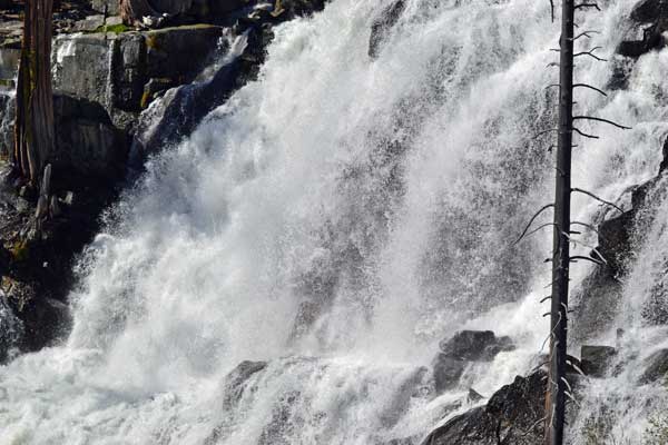
Hiking slowly up the trail, I was not to go very far. I had been to the top of Horsetail Falls a few times before, but as a more adventurous and stronger hiker, with possibly better trails, back then. I stopped for pictures of the roaring creek. I had a tripod along for better movie clips. Gaining a distant view of the falls, I used my telephoto lens. I soon came to the wilderness boundary, and filled out a permit tag. A few other hikers were about.
I soon navigated brushy trails, and finally came to several smaller side creeks, and the same old, wet, shaky logs crossed the rushing water. I took pictures of all three of them, and got one foot wet stepping on a slightly submerged rock. Later, other hikers were seen to just get wet feet. Hiking up the side of the hill to the left, I came to a nice view of the falls, and stopped for movies and photos. Other hikers had gone further, but this would be it, for me today. Despite being prepared with jeans, I knew it would be a heavy brushwhack to get to where I wanted to go. I had my pictures, so turned back.
It was a nice late afternoon saunter back to the cars, and I shot one more set of movie clips on my way back. Driving east on U.S. 50, I saw the new rockwall on Echo Summit Grade, and then descended to South Lake Tahoe. Securing my room, I shortly left to head for Stateline, NV. I'd catch magic hour there, for whatever that was worth.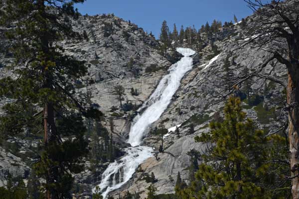
Going into a casino, I spotted a reasonable buffet price, so chose that on the spot. I captured the views from the 18th floor, and the low light on the surroundings was pleasant to see. I had two plates, and remembered how one time, I had taken two friends who had flown up from Southern California to climb some Northern Sierra peaks, and then to enjoy such culinary mountain treats. South Shore seems to have lost a lot of business.
It was out onto the street to do some photography, and I liked the new development on the California side, with fountains, art, and neon. The sunset wasn't very good, so I walked back to my car, and motored back to my motel.
Not able to sleep, I waited till about 4:30 a.m. to motor to the lakefront stroll, where I captured the dawn glow on the waters. Then, it was to check out some new eats for breakfast. Motoring back to my motel, I lay in bed trying again to doze off, but finally got back up to head for some icy soda drink.
On my way to Eagle Falls, I stopped at the new parking area, Inspiration Point, overlooking Emerald Bay. It was nice to see what was fairly new about Lake Tahoe. Using my annual park pass, I parked at the Eagle Falls area and started to take pictures of the lower Eagle Falls. I discerned a short scramble to a better view of the lower falls, and shot many movie clips with my tripod. Then, it was up the trail to Upper Eagle Falls, with a loop to a vista point, and then to the bridge crossing over the falls.
 I now had time to kill. It would still be hot when I got back home. I had more drink, then motored back along U.S. 50 to Pyramid Creek trailhead. Using some time shooting the lower cascade on the creek loop, I was wary of injury. People with dogs gave me cause for concern. Then, it was back slowly to my car, and then to endure some road work delay at a few spots along U.S. 50. They are laying new blacktop, a nice sight to see.
Stopping at the ranger station, I used more time to give a trail report, then sought more drink about some new foothills development. Figuring on getting home early then, I got back, and had made this such a short, easy trip, suited for photography more than anything.
Driving 240 miles, I had hiked maybe 5 miles with 700' gain. I did some 500 still images and movie clips. Including lodging and gas, my total expenses were about $100. I saw no mosquitoes, but lots of other bugs. Hoping for higher quality and to do some 1080p size webwork, I think that I am disappointed at the hardware that I own. I had thought to get a new camera, but technology still has a long way to go. My downloads are too big for most people, and my movies boring. As far as I know, no one has ever seen any of them!
BACK TO PETE'S
THOUSAND PEAKS HOME PAGE