RALSTON PEAK 27X August 2, 2008
 After a time of frugality, with costs up to 4.659
for a gallon of local, regular gas, the price sank to 3.999 this
Saturday morning. Summer was passing by. I was still waiting for
a weather window for a trip to the Northern Rockies, but due to
my concerns about limiting my driving for global warming and conservation
purposes, I ignored one window in the past week. The ten day now
showed a near constant chance of rain and lightning out there
for the next week, so I began to wonder if I shouldn't save this
trip for next summer.
After a time of frugality, with costs up to 4.659
for a gallon of local, regular gas, the price sank to 3.999 this
Saturday morning. Summer was passing by. I was still waiting for
a weather window for a trip to the Northern Rockies, but due to
my concerns about limiting my driving for global warming and conservation
purposes, I ignored one window in the past week. The ten day now
showed a near constant chance of rain and lightning out there
for the next week, so I began to wonder if I shouldn't save this
trip for next summer.
I can quickly make alternate plans, and
the idea of day climbs back here in the Northern Sierra didn't
sound so bad. I badly wish to lose weight, and I can have my peak
fun and burn lots of calories for still fairly cheap. Walking
about town on flat sidewalk and bike trail isn't as good as climbing
a mountain. As far as road trips, there's a few peaks in Utah
and Nevada that I can climb in the fall, too, a favorite time
for me.
The number of hits on my website has really
fallen, and no one is coming forward to carpool and climb. The
economy is not so good, and venues for climbing, now, may sound
frivolous to many.
I rapidly packed my gear and prepared to
do Pyramid Peak (9,983'), a great workout, with nearly 4,000 feet
of gain. Stopping at the USFS ranger station, they told me that
cars were being ticketed due to the poor parking situation along
U.S. 50. I filled out a wilderness permit, and as I motored past
the former, road shoulder, parking op past Strawberry, CA, I decided
not to risk a fine. It looked like some pick-up trucks were parked,
though, but my usual parking for this use trail was orange coned.
I had only seconds to decide as I whizzed by. I'd rather have
more peak ascents on Pyramid, a much more worthy peak, but Ralston,
again, would have to do, today.
 I
had a roll of Kodachrome that I wished to finish, so packed my
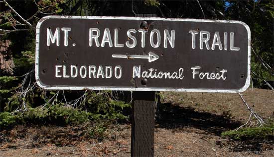
big, heavy film camera. Starting up the Mt. Ralston trail by about
10:15 a.m., I hiked up the initial dirt road. The self service
permit station had plenty of blank forms to fill out. On the morning
TV news, they had said how the wildfire smoke had all dissipated,
and the weather was forecast to be excellent. Indeed, this was
as good as it gets, for Northern Sierra summer peak hiking.
I
had a roll of Kodachrome that I wished to finish, so packed my
big, heavy film camera. Starting up the Mt. Ralston trail by about
10:15 a.m., I hiked up the initial dirt road. The self service
permit station had plenty of blank forms to fill out. On the morning
TV news, they had said how the wildfire smoke had all dissipated,
and the weather was forecast to be excellent. Indeed, this was
as good as it gets, for Northern Sierra summer peak hiking.
I worked up a chat with two other hikers,
and didn't snap as many photos as I normally would. My memory
cards are now well tested. A month ago, though, one card gave
little warning as it failed, and I had to return it to the manufacturer
for a replacement. Some of my work was lost forever. At least
I got that card for cheap, with a lifetime warranty.
Soon, I rested after feeling the slight
altitude, and drank more of my two liters of water. I really need
to climb more often, as I get out of shape too fast, now. From
the high, 8,440+ foot saddle, I chose to go the longer route by
the designated trail, instead of the more direct use trail. I
had plenty of time. This longer way is more gradual, and some
years, it has a vivid, colorful, wildflower show. Not so
much this season, though.
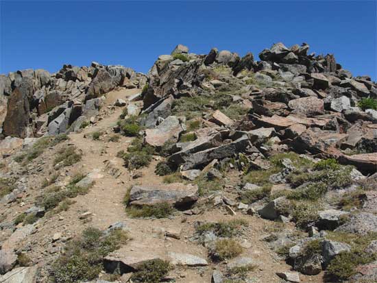
On the top of the ridge, the side trail
to the summit was marked by a cairn and stick. In the past, this
side summit trail was much less distinct. I waited a bit for the
other two hikers, but they went over to see a view, so I left
for the top. It had taken me to 1:39 p.m., to finish the hike
to the top--pretty slow. But, I was carrying a heavier load, and
speaking with the other hikers, had taken my time.
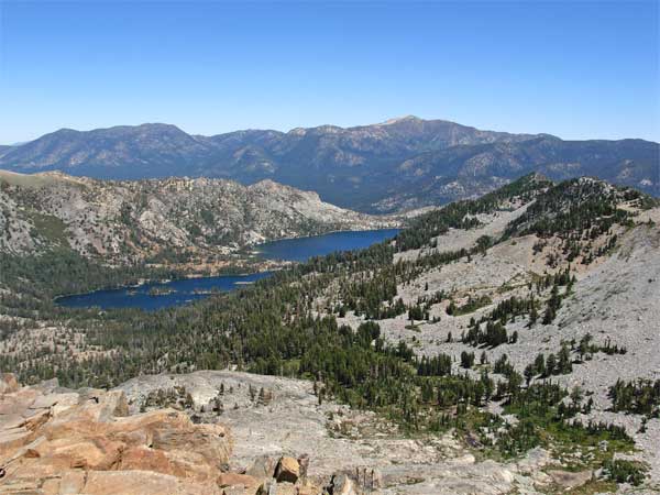
There was a good breeze. I began snapping
pictures, with the typical summer
vistas. Only a few clouds on the southern horizon. The Sweetwater Mountains along the
CA/NV border were clearly seen. I surmised some peaks about Sonora
Pass were peeping out from above a ridge. The Crystal Range had
some residual snow, with none or very little seen about the other
peaks. I could see the boats on the lakes, and cars on the highways.
 Other
hikers came up, and I rested nicely. Good to be doing this, rather
than my usual, flat, city and river walks. I shot more pictures
as I wished, then started back down at 3:30 p.m. Some few more
hikers were climbing up the trail, and my total round trip time
was 7:17.
Other
hikers came up, and I rested nicely. Good to be doing this, rather
than my usual, flat, city and river walks. I shot more pictures
as I wished, then started back down at 3:30 p.m. Some few more
hikers were climbing up the trail, and my total round trip time
was 7:17.
To a phone, I asked a potential partner,
living in Lake Tahoe, to meet me at Echo Summit. It's my policy
to meet first before doing any peak together. We chatted by the
Echo Lake Chalet as I drank a beverage, and got to know each other
better, though I was a bit tired and refused to commit to another
peak this weekend. We talked till dark, and I had to leave.
Having a burger in Placerville, I was shortly
home, and unloaded my gear, showered, and got to my computer.
The hike entailed about 9 miles with 2,800
feet of gain, round trip. I captured about 230 images, mostly
of the sights from the summit. I had spent $20 for gas, and maybe
$9 for food and drink.
It was shorts and T-shirt weather, all
day. I became a bit dehydrated, but replenished my bodily fluids
once back to a store. With a few bugs about, I saw no mosquitoes.
I think there is no stagnant water along this trail, right now.
I am prepping this person for a few future
peak climbs, as he says he is also interested in climbing peaks
in the Coast Range, when it cools down. What my web offers bring
to me. The outlook is grim for more travel and such "frivolous"
activities, by most people, but I seem to remain the only person
from the past, local, peak sections, to keep doing this.
BACK TO PETE'S
THOUSAND PEAKS HOME PAGE