2007 Northern Rockies Road
Trip continued (Page 2)
 Tuesday, the 7th, I motored north on U.S. 95, a
scenic highway. I recorded the smaller towns along the way, and
was feeling good. I would get through these hottest areas for
the trip, and, this day, it was cool enough, and later, overcast.
Coming to Riggins, ID, I inquired about a "road closed"
sign on the turnoff that I was to take. The helpful rangers showed
me a detour on the maps, and said the mostly gravel road was good,
but it turned out to be two miles longer. I jumped at the information
and was on my way.
Tuesday, the 7th, I motored north on U.S. 95, a
scenic highway. I recorded the smaller towns along the way, and
was feeling good. I would get through these hottest areas for
the trip, and, this day, it was cool enough, and later, overcast.
Coming to Riggins, ID, I inquired about a "road closed"
sign on the turnoff that I was to take. The helpful rangers showed
me a detour on the maps, and said the mostly gravel road was good,
but it turned out to be two miles longer. I jumped at the information
and was on my way.
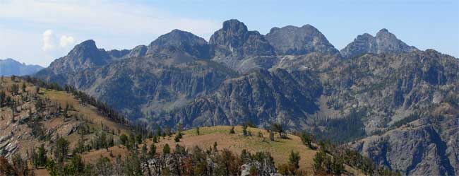
My library guidebook used the words, "most
magnificent," in describing the view from the Heavens Gate
lookout where I was headed. I mostly stayed in second gear on
my drive up, and gained views along the way. Soon, I was high
up, and saw that the smoke had mostly settled into the valleys,
leaving the clear vistas of the Seven Devils Mountains (top photo),
and parts of Hells Canyon National Recreation Area.
It is a short, 350 yard, trail to the lookout,
and I was immensely enjoying the vistas
all about. A few other hikers were about, and although you cannot
see the Snake River, the sights were splendid.
Back to Riggins, I shot the town features,
and saw some rafters on the Salmon River. Then, I had a excellent,
scenic drive, north. Many turnouts and historic points led to
my shooting so many more photos. I
had read of the history of the Nez Perce tribe, with a National
Monument of a battleground along the way. The sky was nice, with
huge clouds and hazy light. This was all new country to me!
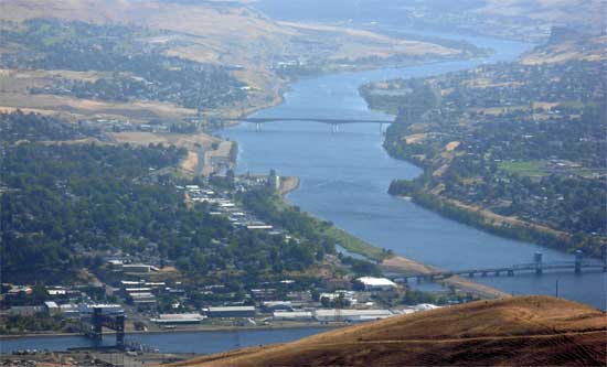 Coming
to flatter land, and keeping to U.S. 95, I stopped at the official
vista point, at the top of the Spiral Highway, with a great, although
hazy, vista, of the Clearwater and Snake Rivers, and the towns
of Lewiston, ID, and Clarkston, WA. I stopped again in the town
of Moscow, ID, looking like this was a nice place to live.
Coming
to flatter land, and keeping to U.S. 95, I stopped at the official
vista point, at the top of the Spiral Highway, with a great, although
hazy, vista, of the Clearwater and Snake Rivers, and the towns
of Lewiston, ID, and Clarkston, WA. I stopped again in the town
of Moscow, ID, looking like this was a nice place to live.
Through rolling hills, I continued north
on U.S. 95, expecting some good scenery about Lake Coeur d'Alene.
There was no highway vista point, but I then came into Coeur
d'Alene, ID. This is an upscale resort, with nice development,
and boat rides and things to do. I parked, and walked about, wishing
for more time here. I didn't get any food, but got more fuel,
and then headed west on Interstate 90 to Spokane, WA, where lodging
was cheaper. I had another sausage and eggs dinner, and resolved
further, then, to lose some weight on this trip.
Up at a good hour, Wednesday the 8th, I
motored through part of town, and headed back east to drive-up
Mt. Spokane. Roads were closed, and I had no good maps. I guessed
right at a way to go, and then came to WA 206, the highway to
the top. The weather was bad, and clouds completely obscured the
view, said to be great. I had no time for any clearing, so motored
on, shortly, after a few summit shots of the stone house on top.
The clouds allowed for a shot from
below the top, though.
The clouds lay over the Interstate, too.
I made a stop at Treaty Rock, with historic carvings and glyphs.
It remained overcast, so I passed by Coeur d'Alene. Now, there
were no better photo ops than the late afternoon sun, the evening
before. I motored east on I-90, planning to visit more towns.
I was disappointed by Kellogg, ID, but Wallace,
ID, was impressive. I had my usual fun walking about and snapping
lots of photos. These are old mining towns, with plenty of historic
buildings.
 I
had no reservations this night, so had to work on that. The overcast
cleared to blue sky and clouds past Lookout Pass. I made quick
stops in St. Regis, and Superior, MT. Then, I came to Missoula,
MT. I was set on the best peak, the next day. I planned to camp,
since I was told that the Bitterroot Valley was as expensive,
for lodging, as Missoula.
I
had no reservations this night, so had to work on that. The overcast
cleared to blue sky and clouds past Lookout Pass. I made quick
stops in St. Regis, and Superior, MT. Then, I came to Missoula,
MT. I was set on the best peak, the next day. I planned to camp,
since I was told that the Bitterroot Valley was as expensive,
for lodging, as Missoula.
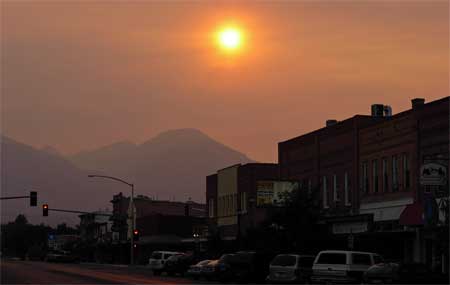
Motoring south, then, on U.S. 93, I was
headed back into more smoke. Arriving to Hamilton, MT, this smaller
town turned out to be a surprise. It has a historic section, too,
but then with diffuse light from the smoke. The Bitterroot Range
to the west was silhouetted by the smoky fires, but I was here.
I found a motel by chance, and then got a reasonable room rate.
So, Thursday the 9th, I got up, with a
motel wake-up call, and had a moderate, early, breakfast. Motoring
south, I followed some good directions, and after about 50 minutes
of slow driving along the gravel approach road, came to the trailhead
for Trapper Peak, the highest summit of the Bitterroot Mountains.
A good trail leads to the top. Sighting
an elk, I had some fears about grizzlies and wolves, with some
Net info about their historic habitat and reintroduction. I ran
into another solo hiker, and my worries were dispelled. Up higher,
the smoke had mostly sunk into the valleys, and the summit vistas
were O.K. I relished being successful, with a time of 3:10, and
snapped away at the gorgeous scene.
The other hiker came up, and I later had my fill of pictures.
Clouds were building up. I sought to find
a better way down, getting into class 2 talus and a false summit
on my ascent, but a use trail took me way down to the south, and
I then had to traverse way left, back to the trail. I sped down
back to the car, and thunder boomed in the distance just as I
returned.
 Motoring
carefully down the rocky and partially rough road, I was back
to the paved highway by about 4 p.m., and then zoomed back north
on U.S. 93.
Motoring
carefully down the rocky and partially rough road, I was back
to the paved highway by about 4 p.m., and then zoomed back north
on U.S. 93.
I had to make Helena, MT, tonight. I managed
to get through rush hour traffic in Missoula, then it was light
traffic eastward on I-90. Lots of smoke overhead. I took U.S.
12 through highly rural parts of Montana, then came to the "visitor-friendly"
town. Room reservations and a reasonable, set price are sure nice!
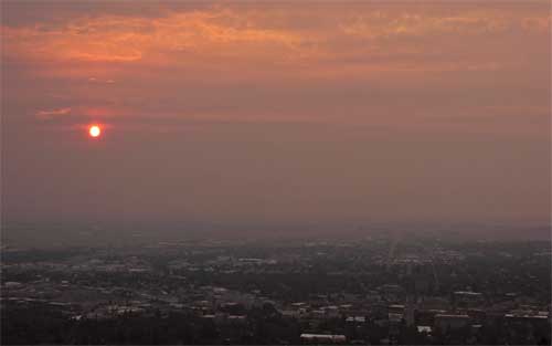
Friday, the 10th, I woke up early again,
to hike the local Mt. Helena City Park, with a prominent mountain
to easily summit in this part of town. Trails led up nicely, with
a smoky sunrise (bottom photo left), and plenty of other hikers
getting their exercise. The view of the town was nice, and shortly,
after a small summit loop on the trails, went back to my motel
room. After visiting the nearby State
Capitol, I was enjoying coffee and a cookie at a bakery in
town.
Checking out of my motel, I headed south
on Interstate 15. I came to Butte, Montana, which I had longed
to see better. I walked about the historic
section of town, with an ongoing Irish festival. I did this
quickly, then drops of rain fell as I was finished.
Continuing south on I-15, I enjoyed relaxing
and making stops along the way. Yellowstone National Park was
to the east, a temptation with scenic mountains to be seen in
the distance. I would do that later, seeing more of that park,
on another road trip.
Passing under various storm cells, my windshield
got a good wash, and I looked forward to better weather southward.
Next