 Seeking to do a couple peaks on this coldest day,
so far this winter, I chose to also save some gas burned by bagging
these two peaks, both, in a day. Waking up at 3:45 a.m., I had
only three hours of sleep, then.
Seeking to do a couple peaks on this coldest day,
so far this winter, I chose to also save some gas burned by bagging
these two peaks, both, in a day. Waking up at 3:45 a.m., I had
only three hours of sleep, then.FISKE (2,868') 12X AND MT. ST. HELENA (4,343') 22X January 13, 2007
Seeking to do a couple peaks on this coldest day,
so far this winter, I chose to also save some gas burned by bagging
these two peaks, both, in a day. Waking up at 3:45 a.m., I had
only three hours of sleep, then.
Enjoying a regular restaurant breakfast of plenty of sausage, eggs, and hotcakes, I had motored north on Interstate 5, then to Woodland. I got my second refill of coffee, then it was time to go. The dawn light grew brighter on the Coast Range's Blue Ridge mountains ahead of me, and I came to the Cache Creek Canyon Regional Park by early sunrise.
Starting my hike at 7:36 a.m., I hoped to make good time. I took the standard trail, and wore my heavy insulated parka. I had problems with weak batteries on one camera, but luckily I had brought along two. I soon saw I was slow, but continued. Then, I came up to the main ridge, and knew I'd quickly be atop Fiske.
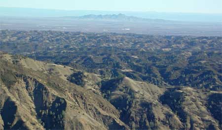
Arriving on the summit at 9:53 a.m., I began to shoot photos of the view. Mt. Shasta had appeared in the distance, earlier, but the haze soon obscured that mighty giant. Lassen's snow was visible, and the Sutter Buttes were clear enough. There seems to have been some new trail work, with the regular dirt trail going directly to the top, now. I didn't remember a small rock/landslide that the trail goes over and about, too.
I had brought up another glass jar and book, in case the register was gone. A futile effort. The register was fine, placed by me in 2004. Not many hikers visit this summit. I used both cameras, and then knew I had to start back down. I was running behind the times of my first double bag in 2001.
 No
other hikers would appear on this trail this morning, and I continued
to wear my heavy parka. I made better time going down, and then
rested, and drank the remainder of my one liter of water. I was
looking forward to getting back, and also forlornly figured that
I would be hiking in the dark coming back from the summit of Mt.
St. Helena.
No
other hikers would appear on this trail this morning, and I continued
to wear my heavy parka. I made better time going down, and then
rested, and drank the remainder of my one liter of water. I was
looking forward to getting back, and also forlornly figured that
I would be hiking in the dark coming back from the summit of Mt.
St. Helena.
Back to the car at 11:57 a.m., I quickly motored off, north on CA 16. It runs into CA 20, then south again on CA 53. I stopped for a powerade drink, and did that make me feel better! I hadn't snapped any photos of the drive in between the peaks, but there was almost nothing that scenic.
Finding a great parking spot right away, I started up this second peak at 1:26 p.m. I had stripped down to four layers, and often carried my gloves and warm cap in my hands, to cool off a bit.
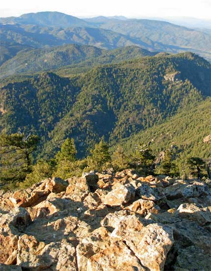
As I hiked up, the sun was still high in the sky. Other hikers were headed down. I admired the views, and got many images with my new camera's telephoto. Then, I was nearing the summit. I had the top to myself, getting there in slightly over two hours. Snapping away, I saw a large bird soaring about. The Sierra was visible, and one of the few times this happened, I could clearly see the Pacific Ocean.
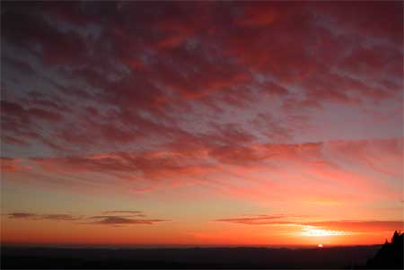
After shooting so many photos, I started down at 4 p.m. I had one flashlight and two headlamps. No worry. Declining to top the mid-peak, I sauntered down and encountered some late hikers. It was getting colder, and then, they turned around. I watched as the sun cast its reddish light on the Palisades, a set of cliffs along the ridge to the south. Then, the sun began to set. It was truly a good magic hour, and I tested out my camera scene modes. The clouds and cliffs lit up red, and I was able to capture good images while near Bubble Rock. Then, the lights of the Napa Valley below began to twinkle on. I knew a rock to steady my camera, but then, almost all of my shots came out blurred. But anyway, Calistoga is not Vegas!
I used my handy $4 flashlight, and then
came upon two hikers who couldn't see in the night. I helped by
guiding them down, as there are many rocks and roots to trip someone,
and possibly break a leg. It was pitch black without the light.
I came back to my car at 6:22 p.m., and some people had a regular
party going in the parking lot. A campfire and bongo drums were
going.
 Taking
off, I twisted and turned down the winding mountain road, CA 29,
with lots of oncoming traffic. Relieved to make it down to Calistoga,
I looked for parking to stop and get some fine food. But, that
couldn't be easily done until Napa. A plate of curried noodles,
shrimp, chicken, and beef, with onions, bean sprouts, and cabbage,
plus lots of tea, put me in the right mood.
Taking
off, I twisted and turned down the winding mountain road, CA 29,
with lots of oncoming traffic. Relieved to make it down to Calistoga,
I looked for parking to stop and get some fine food. But, that
couldn't be easily done until Napa. A plate of curried noodles,
shrimp, chicken, and beef, with onions, bean sprouts, and cabbage,
plus lots of tea, put me in the right mood.
Traffic on Interstate 80 wasn't too bad, and, having failed to locate a cheap motel back in Calistoga (for another two peaks the next day), I came home by about 9 p.m.
Fiske is 8 miles with 2,300 feet gain, round trip, and Mt. St. Helena is 10 miles with 2,400' gain, round trip. I saved about 110 miles of driving by doing both peaks this way. Spending about $30, for gas, drink, and food, I did well, today. Right now, I am able to stop being so frugal, and spend as I need to. The photos came to over 300 images captured, and with no movie clips.
Wearing my heavy jacket during the whole climb of Fiske, I had four layers on Helena. I carried my heavy pack, but with only one liter of water, and other drink, on either peak. Some cans of soda left in the car stayed cold.
Seeing no bugs, there were maybe a couple dozen hikers on Mt. St. Helena. There looked to be a backpack group, and some hikers were carrying babies. One car came by, and there was one mountain biker. No rock climbers, though. On both trails, there was no mud, at all, and no ice to be seen. Some frozen dirt in a few short stretches made me feel good with the crunchy texture. A few Manzanita were already blooming, as well, but I saw no other flowers.
BACK TO PETE'S THOUSAND PEAKS HOME PAGE