NORTH CHALONE PEAK (3,305') 3X,
AND SANTA CRUZ, CA April 18-19, 2006
 Finally now came forecasts of two straight days
of good weather. I made quick plans, and left home by about 5
a.m., Tuesday. Heading south on Interstate 5, I kept awake with
drinks and slight food, on my way out to Pinnacles National Monument.
Taking CA 152 over Pacheco Pass, I turned south to Hollister,
CA, where I stopped for more drink and rest.
Finally now came forecasts of two straight days
of good weather. I made quick plans, and left home by about 5
a.m., Tuesday. Heading south on Interstate 5, I kept awake with
drinks and slight food, on my way out to Pinnacles National Monument.
Taking CA 152 over Pacheco Pass, I turned south to Hollister,
CA, where I stopped for more drink and rest.
Highway CA 25 shoots down to the park's
east side, where a side road enters the Monument. Parking next
to the Bear Gulch Visitor Center, I began my day's hike at 9:41
a.m. I would make a big loop, the most miles I have ever done
in a day, here. Taking the Moses Spring trail, I passed through
some caves to bypass the partial closure of one cave trail. Coming
to the Bear Gulch Reservoir, I took the Chalone Peaks trail.
This trail climbs at a gradual rate to
the top of this highest peak, North Chalone Peak, in the park.
I was disappointed by the lack of a prolific wildflower bloom,
and then, high clouds turned the sky white. I topped the peak
in two hours, and didn't stay long. The summit photo ops were
poor, and I was determined to do another trail, today.
On my hike down, a nice view of the main
part of the pinnacles was enjoyed, with a small spread of goldfields
(photo). I passed by a dropped ski pole, and noted a blue tarp
covering what may be some camping equipment. Then, I ran into
a few peak hikers.
Back to the reservoir, I took the High
Peaks Trail. This is the best hiking in the Monument, and doesn't
take too long. Several hikers were bound for the trail traverse
at the summit of this loop. Spectacular rock formations presented
themselves from along this trail, and I came to the main ridge.
The view down to the west is gorgeous.
Resting a bit, I tended to my digital camera.
Further along, a bird watcher pointed out a condor sitting on
a rock. Wow! This may have been the first time I had ever seen
one in the wild! I tried for a telephoto picture, but didn't want
to get too close to this magnificent bird. They have a 12 foot
wingspan, and are being brought back from near extinction by wildlife
scientists. The best I could do was to have a larger dot in my
photos, but it points out where the big bird was, at that time.
I clambered on, climbing the rock stairs and using the handrails,
along the precariously situated trail.
Then, as I was enjoying more vistas of
such huge rock formations, I thought I saw the big bird soaring
nearby, and snapped several pictures. This might have been a turkey
vulture, but my zoomed-in photos could tell. It is always worth
returning to these places of nature!
 Soon,
I came to the Condor Gulch Trail, which leads back to the main
parking lot. I had snapped many more pictures of the rocks with
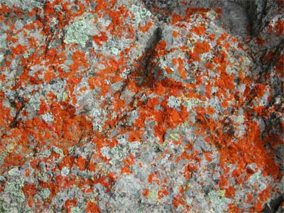
diffuse light, with colorful lichens, and noted my time. Back
to my car by 4:11 p.m., I had hiked maybe 12 miles, with 3,000'
gain, total.
Soon,
I came to the Condor Gulch Trail, which leads back to the main
parking lot. I had snapped many more pictures of the rocks with
diffuse light, with colorful lichens, and noted my time. Back
to my car by 4:11 p.m., I had hiked maybe 12 miles, with 3,000'
gain, total.
I made a trail report to the rangers. This
morning, some important dignitaries had been here, dedicating
a new addition to this Monument.
Shortly motoring off back north to Hollister,
I snacked on some fast food. I pondered on what I would do. It
was plenty early enough to simply drive back home, but now with
gas near $3 a gallon, it might be best to get lodging. I had plans
for more peak hiking tomorrow.
Motoring north to Gilroy, CA, I found a cheap enough motel, and
rested up. I needed a good night's sleep. After more fast food
for dinner, I watched the TV, and dozed off, late.
Hard to get up, Wednesday, I checked out
by about 7 a.m., and got breakfast, then coffee, at a couple fast
food restaurants.
My plan was to climb Mt. Wilson (2,651'),
in a newly opened area for Henry W. Coe State Park. Taking Leavesley
Road east from U.S. 101, this side road leads to a signed auto
tour, which, in about nine miles from the freeway, eventually
comes to Hunting Hollow, the new trailhead. There is a $4 self-pay,
day use fee, and I saw the start of the trail was quite muddy.
Then, a 20 foot wide creek had to be crossed, with no bridge or
rocks to hop on. I have my doubts each time that I start to do
this, but that made my mind up. I'd relax today, with an easy
drive to another mountain park, and Santa Cruz, CA.
Motoring back west on CA 152, I checked
out Mt. Madonna County Park. I paid the $5 day use fee by a machine,
and drove into the park. There is no distinct peak or highpoint,
and the county park mostly seems to be a few campgrounds amidst
redwood groves. I drove about, seeing the place, then determining
that there is no clear point to bag, headed on.
Passing through Freedom, CA, I came to
Highway 1, and shortly, Santa Cruz. Taking Ocean Street, I stopped
at a visitor center. I was given a map, and told what there was
to do and see.
First, I used a free parking garage in
downtown Santa Cruz. I walked along the main street, Pacific Avenue,
snapping photos of everything there is to see. Lots of businesses.
Two historic movie theaters made for some interest.
 Then,
driving west to the Boardwalk, I fed a parking meter, and walked
along the ocean front. The famous Cocoanut Grove building is located
here.
Then,
driving west to the Boardwalk, I fed a parking meter, and walked
along the ocean front. The famous Cocoanut Grove building is located
here.
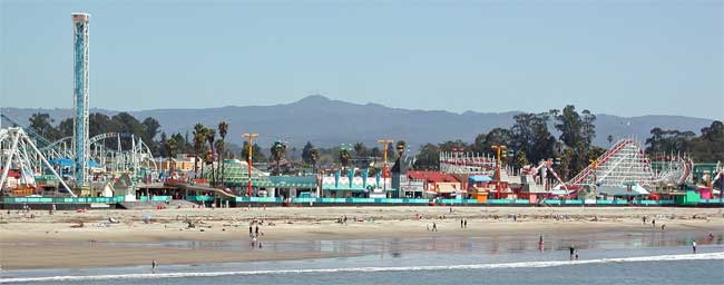
Further, roller coaster rides and other
attractions provided subjects for photos. I walked out on the
pier, and captured a panorama, with Fremont Peak (3,171') in the
background (photo). I tried for more photos, then went back to
my car. A nice shoreline drive made for more stops and photos.
Surfers were using the waves, here, by the dozens. That looked
like fun to do, with smaller sized waves to ride.
There is a surfer museum, and a seacoast
natural bridge. Finished with my sightseeing, I headed back into
town, for more refreshment and rest, then motored northeast on
CA 17. Wondering if I should try Mission Peak for more exercise,
it began to get warm. I had to turn on my air, and so, figured
to get home earlier.
Getting to I-680, I meandered about downtown
Walnut Creek and Concord, CA, looking for gas, then found some,
at 2.959. Back up to Interstate 80, I completed my loop, with
only, then, the one peak.
I walked or hiked some 14 miles, with the
roughly 3,000' gain at the park, and shot almost 600 images. Spending
about $100, with gas and the motel taking most, I brought back
only some free brochures.
Using a few, light, top layers for clothing,
I had on some light weight bottoms under my jeans. I would have
worn shorts and T-shirt, if I had a place to change, later in
the day, both days. Cool at the coast, I wasn't bothered by any
bugs, and all my gear held up well.
Despite a recent, newspaper story about
muddy trails all over the Bay Area, there was no such problem
at Pinnacles. They do great work building and maintaining trails
in a national monument. The sand or rock, used, drains and dries
very quickly. The waterfall at the reservoir dam flowed nicely,
and only a few, very small creeks had to be stepped over.
I may have to come back in the fall, perhaps,
for Wilson Peak. It looks like a nice, easy, bump to hike. Also,
I might have returned through San Francisco, but for the Highway
1, Devils Slide closure. Another mudslide had closed the scenic
highway, and no quick repairs can be made.
Looking forward to doing a few local hikes,
too, another road trip is contingent on a few, straight, forecast,
days of sunshine. Hoping for Oregon, I will wait for my next,
big, peaks adventure.
BACK TO PETE'S THOUSAND
PEAKS HOME PAGE