2005 ROCKY MOUNTAIN ROAD TRIP Page 2
Getting up early and having a croissant and coffee at a Leadville bakery, I headed south on U.S. 24 to Buena Vista, CO. Taking the paved Cottonwood Pass side road all the way to the trailhead, I began my climb of Mt. Yale. My start was about 7:45 a.m. Another good trail leads up some 4,300 feet gain to the top, via a short class 2 ridge. Being a Tuesday, I was liking having other hikers about. So many people work on climbing mountains for their time off!
Able to maintain my thousand feet vertical
per hour climbing rate, I summited by about noon. Perhaps a dozen
other hikers had topped out today. The views
were nice, with hardly a cloud in the sky. My tiredness had required
me to leave one camera in the car. Well, it is nothing like the
Sierra. Many Colorado peaks are rounded bumps. Only a few are
technical to any extent.
Going down went fast, and back to my car, I motored back into Buena Vista to look for lodging. As many times this trip, the set rate was too much. This usually meant from 55 to 70 dollars for a single. I motored east on U.S. 24. The rolling terrain was photogenic, but the Florissant Fossil Beds National Monument was closed when I got there. Pretty area, as much of this fine state, but there seemed to be no great camping ops. Too warm, anyway. Fatigued, I almost broke down to pay the requested high room rates in Colorado Springs. Then back in Manitou Springs, CO, I found a rundown place to save my money, and charged up my camera batteries.
Record highs were being set, and forecast, while I was here. Wednesday morning, I first hiked the scenic, Garden of the Gods park. A stipulation kept it free to the public, so I walked the pathways and watched some morning rock climbers. Walls and pinnacles of red rock caused me to record the scenes. Seeing the balanced rock, I motored out of the park.
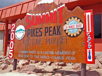
Next was the famous cog railway that goes to the top of Pikes Peak. I found the depot, but gasped as I was asked for reservations, at the $29, per one adult, fare. Would I come this far to be denied a seat? The good ticket person relieved my anxiety by saying there was an excellent chance to be called from stand-by. It was the 9:20 a.m. run. A big crowd must mean bitter disappointment for some, at busier times.
My number was called and I got my seat. This is a popular ride! Humorous commentary, by the tour guide, marked the ride up, at a steady 10 m.p.h. It takes about an hour ride to the top, with a 40 minute wait to allow me, in my madness, to clamber over rocks to the true highpoint. Others enjoyed the view from the balconies, and visited the gift shop or ate doughnuts.
Virga marked the vistas down eastward to Colorado Springs, and dark clouds formed overhead. You have to take the same cab down, so I barely had enough time to walk about and snap the obligatory view photos. My seat number was an aisle seat, but I got plenty of views during the ride. Some large animals were seen running in the distance--elk, I think.
This made a novel change for me, one that I would have snubbed at a earlier time in my life. A good dirt road also leads to the summit, but I would enjoy this fine train ride. I support mass transit. Back to Manitou Springs, it was now early afternoon. I speculated on what to do. I headed south on Interstate 25, through Pueblo, CO, then to Walsenburg, CO. U.S. 160 would lead west toward the Great Sand Dunes National Park and Preserve. I knew the camping there was terrific. As it cooled off for the evening, I ventured to enter the park. I took a campspot, and hiked the Dunes Overlook trail. The ranger talk at the nearby amphitheater was appreciated. Old fashioned slides made for the show about hiking in the area.
 Sleeping
fair enough, I found the campground soda machine was broken. So,
I didn't get my caffeine for the morning. I went to the Dunes
trailhead, changed into my old boots and socks, and set out for
the short climb to the top of the nearest high dune. Some young
adults were having a rough time. I stepped in footprints and followed
the easier grade of the ridges. Topping out in about an hour,
this was stated to be 700 feet gain, with a mile and a quarter
to hike, each way. I liked the views of the other dunes. Star
Dune is said to be taller, but it looked higher here. I had my
telephoto lens for my film camera, so snapped away. The others
must have been envious that I had almost a liter of water. They
all had carried up nothing much, except for a football.
Sleeping
fair enough, I found the campground soda machine was broken. So,
I didn't get my caffeine for the morning. I went to the Dunes
trailhead, changed into my old boots and socks, and set out for
the short climb to the top of the nearest high dune. Some young
adults were having a rough time. I stepped in footprints and followed
the easier grade of the ridges. Topping out in about an hour,
this was stated to be 700 feet gain, with a mile and a quarter
to hike, each way. I liked the views of the other dunes. Star
Dune is said to be taller, but it looked higher here. I had my
telephoto lens for my film camera, so snapped away. The others
must have been envious that I had almost a liter of water. They
all had carried up nothing much, except for a football.
After my photos, I headed down at a good run. Back to my car, I dusted the sand out of my boots and socks. This was it for me, here. I motored back to U.S. 160 and headed west. Alamosa, CO, made a nice town for another quick walk and photos. I often had a small sandwich and drink to use a restroom. Plenty of fast food in the larger towns. I had skipped the turnoff south to Taos, and the highpoint of New Mexico, Wheeler Peak (13,161'). I will leave this for another trip, maybe a late fall visit to Santa Fe and Albuquerque.
Asking a ranger about travel times, I resolved to get to Lake City, CO, for another hike, a double climb of both Red Cloud and Sunshine Peaks. Pleasant scenery marked the drive through Del Norte, South Fork, and Creede, CO. Photo stops at the vista points used up some time. I arrived to Lake City to find an "inexpensive" motel requested 69 dollars a night. Summer rates. I got some drink and food, then motored slowly up the rough road to the peaks trailhead. Camping here was free. Other people had the same itinerary for the next day. There is a real camaraderie for doing the Colorado 14'ers!
Rain fell overnight, and I feared an overcast or wet morning. It dawned clear after some high clouds broke up. This was it. Would I do this and regain some self-esteem?
 Starting
up the trail by 6:20 a.m., Friday, I took three liters of water.
This would be a longer day. Following Silver Creek, I took the
trail in good stride. In a high basin filled with flowers and
greenery, I was passed by other hikers. Some could be seen atop
the first peak, Red Cloud, already. The trail climbs well, and
by about 10 a.m., I was atop Red Cloud. The peak has nice red
rock, making for a good photo op.
Starting
up the trail by 6:20 a.m., Friday, I took three liters of water.
This would be a longer day. Following Silver Creek, I took the
trail in good stride. In a high basin filled with flowers and
greenery, I was passed by other hikers. Some could be seen atop
the first peak, Red Cloud, already. The trail climbs well, and
by about 10 a.m., I was atop Red Cloud. The peak has nice red
rock, making for a good photo op.
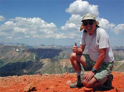
I saw there was also a good trail over to Sunshine Peak. I followed another hiker over to this second peak. Clouds were forming, but I was told it was not yet a hazard. It took me under an hour to hike to Sunshine Peak, done only this way, in conjunction with Red Cloud. We signed in the deficient summit register. No one seems to maintain these very well. I snapped more photos. The vistas of the other peaks of the San Juan Mountains I had waited for a long time to see. Glorious! Cloud shadows over the summits and slopes impaired any great photos, but at least I had made both peaks. It is recommended to climb back to Red Cloud rather then drop down a long rocky slope to the trail and canyon below. One hiker decide to try the shortcut, and he reported it as "not bad." I climbed back to the top of Red Cloud and snapped my own photos.
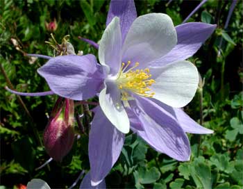
A few hikers had come up behind, so I knew I would not be the last one on the peaks. I safely hiked down the trail, over snowfields, and along the good sized creek. Lots of columbine. Back to the trailhead by about 3:15 p.m., I carried up a conversation with an old time peak climber, him stating to "700 peaks." Then, it was time to motor slowly down the rough road. This went on for only a few miles, then I was back to good dirt road, and then, blacktop.
BACK TO PETE'S THOUSAND PEAKS HOME PAGE