HORSETAIL FALLS May 30, 2005
Game
for another short hike this holiday weekend, I pondered over what
I might do. Leaving home after the noon news, I made up my mind
as I pulled out onto the freeway. It was probably a choice of
what road I get stuck on, but then, with the warm temperatures
in town, already, I thought to go high.
Motoring east on U.S. 50, I knew if I came
home later, the traffic might be less. After three days of play,
many people choose to return home early.
 I
haven't done this easy hike for a few years, the last being with
the Reno Sierra Club in mid-summer. This hike, in 1971, was my
first introduction to local chapter trips. It was easy to see
how they lose hikers. No safety policy. A few other hikers have
been killed here, with some going over the falls. A slip on angled
slabs, with boots or sneakers with poor traction, can happen easily.
There are places where you'd slide into the rushing creek. No
hope for survival without a rope and a good buddy to use it.
I
haven't done this easy hike for a few years, the last being with
the Reno Sierra Club in mid-summer. This hike, in 1971, was my
first introduction to local chapter trips. It was easy to see
how they lose hikers. No safety policy. A few other hikers have
been killed here, with some going over the falls. A slip on angled
slabs, with boots or sneakers with poor traction, can happen easily.
There are places where you'd slide into the rushing creek. No
hope for survival without a rope and a good buddy to use it.
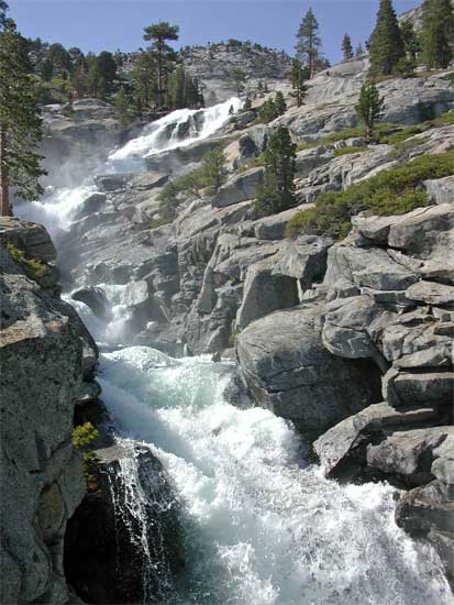
I came to the Pyramid Creek Trailhead after
noting some slowdown, westbound, along the canyon highway. I got
a spot right away. I paid the $3 parking fee, using the envelopes
and the iron ranger, and made ready for this hike. Starting out
at 3:15 p.m., I hoped that the afternoon light would be good.
The falls faces south, and a high sun illuminates it nicely. If
nothing else, I hoped to get some good pictures. I began shooting
movie clips (8.3 MB, 2:02, 320 x 240 pixels) of the white water as I came to it. Beautiful! Amidst
the torrents, whirling pools of deep green also made for photos.
Years ago, the local REI and the USFS put
together a volunteer effort to construct a single trail, out of
all the use trails, to the wilderness boundary. We had about 100
people working under ranger supervision to lessen the impact of
many a hiker, each going their own way. I failed to remember the
route that was chosen, but the way is still not very obvious!
Hiking over huge granite slabs, I followed the trail as best as
I could remember. I filled out the wilderness permit tag at the
self-serve station on the wilderness boundary.
I spoke with a wilderness ranger about
certain matters, and asked about summit registers. He wasn't so
sure about policy, but finally reiterated that they don't belong
in wilderness.
The trail route gets more obscure past
the wilderness boundary. The trail route was aflood with water.
Two shaky log bridges are crossed in quick succession, then the
brush whacking starts. The trail route becomes indistinct, and
many would turn back. I have a vague memory of where it goes,
and remembered the large boulder that it winds by. Soon, after
ascending a rocky and awash gully/trail, I came to the base of
the falls. A route exists up through the manzanita, cliffs, and
granite slabs, and only hardy hikers, for tourists, would continue
all the way up here. I recalled a local chapter youth group stopped
below this point, even in good conditions.
I began to snap photos of the falls, up
close. I edged up to the gorge to get a better angle, and shot
movie clips vigorously. Some hikers asked me to snap their picture
with their camera. Obliging them, I continued upward, and found
a good vantage point for the main falls. This was about 6,800
feet elevation. Other hikers were descending, and shortly, my
thought to go to the top of the falls was met by disappointment.
I faintly remembered the class 3 chimney and steep gully, but
I wasn't prepared for that right now. I already had many good
photos of the falls. The light wasn't so good to make going on
worth the effort. There's no better view of the falls, further
along. And much of the route seemed overgrown by new, thick, brush.
So, at about 5 p.m., I turned back. Shadows
were setting in, and the best light on the falls was gone. I carefully
made my way down, seeing a few groups still heading up.
This trail serves to represent the "wilderness"
for the thousands who must choose to take a hike here, and then
nowhere else. Many must meet similar disappointment. While I like
the Desolation Wilderness, most of it is not as poorly maintained,
or "rough," as far as trails. To give so many the thick
brush, flooded trail route, with few or no signs, may serve to
alienate so many hikers who wish to explore, but safely. Such
discouragement may keep visitation low, so the numbers of potential
wilderness enthusiasts are held in check. I suspect the local
chapter has a similar goal.
I found a better way back, but the shaky
log bridges still had to be crossed. With that over, I could relax
a bit. The angle lessens, then the terrain opens up. It is nice,
gentle, glacial terrain, here, with examples of glacial polish,
and many erratics--odd rocks that were deposited by the receding
ice.
Figuring that the highways were still jammed,
I slowed a bit and drank my water. Then other hikers passed me,
headed back. I was back to the parking lot by 6:13 p.m., glad
I made this effort. Believe it or not, I never got my feet wet--good
boots, and careful stepping on rocks around the rivulets and puddles.
There was a breeze, so no mosquitoes--yet. Ticks don't live up
here. And, I did see a marmot!
Fine in shorts and t-shirt, I carried a
smaller pack than usual. One liter of water was fine. Most hikers
I saw carried nothing. Plenty of hikers to help in case of an
emergency, with even one of the two area rangers nearby.
Motoring off quickly, I saw the traffic
was moving well, and stopped for fast food at Pollock Pines. There
would be no great sunset, so I motored on home without another
stop. The nicely uncrowded freeway was a pleasant surprise.
This hike is about 4 miles and 700' gain,
round trip, to the point level with the main falls, with the top
being about 500' elevation further than I went. I snapped over
100 images and movie clips. A nice enough afternoon for my $9
worth of fuel!
BACK TO PETE'S THOUSAND
PEAKS HOME PAGE