 Unable to
sleep again, as my late sleeping causes, I stayed up all Saturday
night, updating my computer software. It came to be about 4 a.m.,
so I figured what to do today. At 6 a.m., I got breakfast and
drink at a local fast food restaurant.
Unable to
sleep again, as my late sleeping causes, I stayed up all Saturday
night, updating my computer software. It came to be about 4 a.m.,
so I figured what to do today. At 6 a.m., I got breakfast and
drink at a local fast food restaurant.FISKE (2,868') 11X AND COLD CANYON LOOP 6X October 23, 2005
Unable to
sleep again, as my late sleeping causes, I stayed up all Saturday
night, updating my computer software. It came to be about 4 a.m.,
so I figured what to do today. At 6 a.m., I got breakfast and
drink at a local fast food restaurant.
Motoring off in the dark of the night, I took Interstate 5 north. Taking the Main Street Exit in Woodland, CA, I continued west, on CA 16. Getting good coffee and a rest break at the CA casino mini mart, I had witnessed the dawn, with reddish clouds. Would it be a fine day!
At Cache Creek Canyon Regional Park, I found that the dirt road gate was open. I motored slowly down to Cache Creek, and crossed the low water bridge. Another car was parked on the far side of the bridge. I chose that spot, too, worried a bit about gate closure or getting a ticket. The currently open, large, paved, parking lot, for the picnic area, has a self-pay fee of $6. I'm not using any of it, but I know rec districts want money!
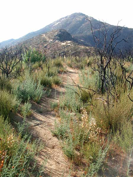
Starting my hike at 8:06 a.m., I took the usual Blue Ridge trail. All side streams or creeks, not major ones, were dry. A few fall colors appeared.
Hiking solo, I had tried for a partner. I often fear for mountain lions, for one thing. Looking at the footprints in the trail dirt, I was keen on sighting any cat tracks. I'd turn back immediately, if I thought a big cat was in the area.
Making good time, I arrived at the Fiske summit at 9:51 a.m. Great that I took only an hour and three-quarters. I looked at the register, and noted new sign-ins. It looked to be in good condition, with plenty of room for more hikers to sign-in. I wished people would use the back sides of the pages to sign.
Hazy today, I quickly shot my usual photos, and left the top by 10:20 a.m. No 100 mile views. I sometimes jumped, and otherwise scurried, down the steep trail. No other hikers were coming up, this fine morning.
Back to my car at 11:52 a.m., I motored off for another rest break and drink at the CA 16 casino mini-mart. The 99 cent sweet tea, in a tall can, is a good bargain, and well quenched my thirst. I took Interstate 505 south, then took the Winters Exit. Headed back west again, I motored along CA 128 to the still primitive parking for hikers at Cold Canyon, or the Stebbins Reserve.
It was 1:26 p.m., when I began this next hike. Contrasting with the vacant Blue Ridge Trail, there were plenty of other hikers. Hiking up the higher, steeper, trail that goes directly to the top of the ridge, I topped bump 1,475' at 2:17 p.m.
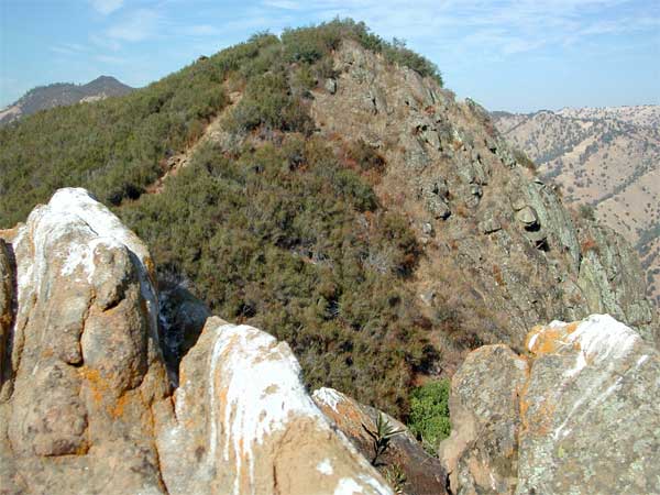 Resting
for twenty minutes, I looked at Lake Berryessa, below. Continuing
to some colorful lichen and fulgurite laden rocks, I stopped for
some pictures. The bump 1,475' is also seen in the second photo
(left), from the south. Ambling over the next bump, 1,580+, I
climbed over a couple more lesser bumps, and began my descent,
down wood post steps. Nice to have an easy hop down, as a steep
climb up!
Resting
for twenty minutes, I looked at Lake Berryessa, below. Continuing
to some colorful lichen and fulgurite laden rocks, I stopped for
some pictures. The bump 1,475' is also seen in the second photo
(left), from the south. Ambling over the next bump, 1,580+, I
climbed over a couple more lesser bumps, and began my descent,
down wood post steps. Nice to have an easy hop down, as a steep
climb up!
Running into a few more hikers, I came back to my car at 4:14 p.m. I had time for another 1,200' gain on Pleasants Ridge, but with my lack of sleep, decided to go home.
I had hiked 12 miles, with a total of 3,800' gain, round trips. I drove about 150 miles. Snapping 140 digital images, I had shot no movie clips.
The trails were all overgrown, and someone might do a good job with hand clippers. Easy to get scratched from sticker bushes, and protruding twigs. Thousands of branches or stems need to be lopped.
Cache Creek and Putah Creek were flowing fine, for this time of year. But, all seen tributary streams were dry. I noticed some new burned areas in the oak woodlands, about the Putah Creek canyon.
I had on two light layers, at most, and jeans. I drank only two liters on the trails. I saw no ticks, or mosquitoes. No snakes, either. Lizards, butterflies, and other bugs made for the wildlife.
BACK TO PETE'S THOUSAND PEAKS HOME PAGE