CASTLE PEAK (9,103') 13X August
27, 2005
A
repeat partner, something fairly new for me, nowadays, had the
Saturday off from work, or commitments. I suggested this class
3 peak, along with Basin Peak (9,015'), as a good double climb.
He agreed, so I picked him up from his home at 7:30 a.m.
Motoring quickly up Interstate 80, we needed
only one stop at Nyack. I had some food and drink there, using
the facilities, and we soon came to the end of the paved road,
north, at the Castle Peak Exit. I parked along the shoulder, and
we started hiking by about 9:23 a.m. Me seeking to update my peaks
guide, we took the side trails, eastward to the Pacific Crest
Trail, along the freeway. I lost the trail in spots, but remembering
how it ran, found it, and soon we were hiking northward on the
PCT. My companion said it was too late in the season to run into
any through hikers, as they would be coming up to Oregon, or past,
by now.
 A
few other day hikers were seen, then we came to Castle Pass for
a quick break. There are now three trails running from here. One
heads left along the ridge to Andesite Peak (8,219'), the PCT
runs down into the meadow to the north, and a use trail, now pretty
visible, runs right up to Castle Peak. We snapped pictures of
the rocks and cliffs, with many pinnacles. Not having been here
since November, 1999, I remarked this should be a wilderness area.
The peak and surrounding crags are nice to see, again.
A
few other day hikers were seen, then we came to Castle Pass for
a quick break. There are now three trails running from here. One
heads left along the ridge to Andesite Peak (8,219'), the PCT
runs down into the meadow to the north, and a use trail, now pretty
visible, runs right up to Castle Peak. We snapped pictures of
the rocks and cliffs, with many pinnacles. Not having been here
since November, 1999, I remarked this should be a wilderness area.
The peak and surrounding crags are nice to see, again.
The use trail climbs steeply, then soon
we could see Lassen Peak. We climbed the northern crag, which
entails a slight bit of class 2. Many hikers presume this is the
top, but I know better. We scrambled down southward on rubbly
use trail, then contoured right (west) around the middle crag.
The use trail is now more distinct, and I needed no scouting to
find the way.
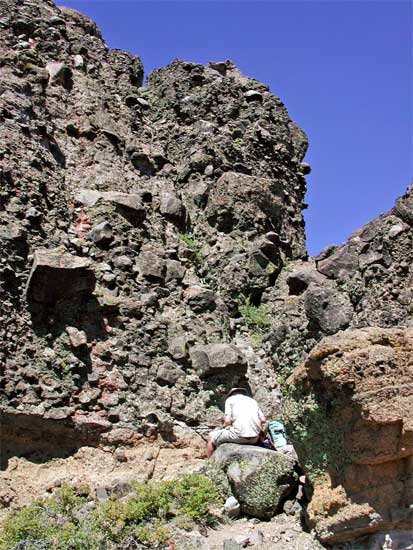
Having a 100' 9mm rope along, for my partner,
I had assumed he had not done much, if any, rock climbing. He
then stated he had climbed in a rock course, but I repeated the
rope commands, like "up rope," and "slack,"
to refresh his memory. I did have to tie his bowline knot for
him, then soon I was leading the rope, taking my time, on the
50 foot high, class 3, section (photo, right). I had no difficulty,
and soon was on top, at about 12:20 p.m.
Setting the rope about a large immovable
boulder, I had anchored myself, and was quickly belaying my partner
up the class 3 agglomerate. He had no problem, summiting in five
minutes, then we were free to enjoy the views. I had left my pack
below, hearing from a local climber that the register was fine.
I had four books and two sets of nesting cans, in case our mountain
records needed maintenance.
The Harding fire to the northeast was hard
to see, with only a layer of smoky air on the horizon. No big
column of smoke. This blaze jeopardized the town of Loyalton,
but it was said later to be 50% contained. Lassen Peak had a stripe
of snow, Lake Tahoe was partially visible, and we could see the
Sutter Buttes and the distant Coast Range. A nice day!
Soon, I belayed my partner down the class
3 section, and then was downclimbing myself. I thought to protect
my moves by running the rope around some likely rocks, but found
myself throwing the rope loose to not get stuck or held up. It
really is a snap, not class 4, like some may say.
I had waited on top to offer to assist
some game hikers, using my rope, but no one came up to take me
for a belay.
Hiking back down after photographing a
rock window, my companion slipped on some ball-bearing gravel.
He suffered some long cuts on his leg. Blood was oozing. I got
out my first-aid kit, and offered bandages and gauze. I told him
to clean the wounds, with spare water out of his canteen, before
applying the materials. It was almost just scratches, but I deemed
it bad enough to skip on hiking the ridge over to Basin Peak.
He reported little pain, and was able to hike normally. I felt
it was important to wash the cuts, immediately, with soap and
water, so we beelined back to the cars, taking the 4WD dirt road
back, from below Castle Pass.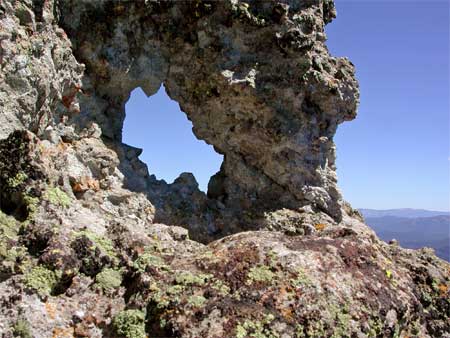
Back to the car at 3:40 p.m., I found the
nearby Boreal Ridge Ski Resort was pretty much shut down. I figured
they had a first-aid station, thinking a slide flume was in operation,
but even the ski museum was closed. We wound up at the Big Bend
ranger station, where he washed and treated his own leg, nicely.
After a quick sandwich in Auburn, I dropped
him off, and was home early at about 6:10 p.m.
I had slipped on this steep use trail,
too, but with no injury. Warning a sizable set of young people,
hiking up toward the top, about my pal's accident, I hope they'd
learn about being careful in the wilderness. Being that it may
have been a school activity, I spoke with a responsible person about
the hazards. Some of them had sneakers, which don't do as well
as lug soles on this type of trail. But it was nice, for us, then,
to have completed the class 3 part with no problem.
We did some 7 miles with 2,000 feet gain,
round trip. I shot almost a hundred images. The round trip from
town is under 200 miles. It was to be 102 there, this day, and
it was getting warm even at 9,000 feet. I had advised my friend
to take plenty of water. But, we had some cool breezes, up high,
and dust and heat plagued hikers and mountain bikers, down low.
We both wore only T-shirts and shorts. I drank only two liters
of water.
I am always trying to be careful, and the photos will show
why you must watch your step, and not get careless. Most accidents
occur on the descent, when climbers are tired and aren't used
to downclimbing. It was important to clean the wound, in due time,
and prevent infection. I've had bad scrapes for days before I
could get back to civilization, as your body has natural healing
and immune systems. But in this case, it was good for him to have
me along, with my two first-aid kits, although this will most
likely come to nothing, similar to a plain bicycle accident. But
bad things can happen in the wilderness, and I don't carry a heavy
day pack for nothing!
BACK TO PETE'S THOUSAND
PEAKS HOME PAGE