ROUND TOP (10,381') 16X June
22, 2003
Checking
on an online associate, we e-mailed each other in preparation
for a Nevada Peaks climb in the Snake Range, about Great Basin
National Park. I have my doubts about recruiting people off the
Net for climbing partners, but then what good is my website? We
had been exchanging e-mails for years, but I had never met this
person.
So, I gambled to give it a go. He came
by, this fine early weekend morning, with his Jeep, but since
our plans had changed, we chose to go in my 41 mpg passenger car.
We were able to start at Carson Pass, up
the PCT, by 10:30 a.m. I was climbing with a stranger. Fortunately,
because of road work and snow, the Blue Lakes Road was closed.
Otherwise, my choice was to climb Da-ek Dow Go-et Mountain (8,990'), a
class 4 peak, for my 4X.
Arguing for a half hour, I had my doubts
about this person. I found that he had little snow climbing training,
and it appeared that he misrepresented his ability and experience.
Thank goodness I wasn't trying to lead 50 feet of class 4 rock
with him on the other end of my rope!
 To
not waste the day, we agreed that he'd hike with me to at least
Winnemucca Lake. I'd see how he did, and if he didn't kill himself
slipping on any of the various, low angle snowfields we had to
cross, maybe I'd reconsider taking him up this class 3 peak. We
did O.K., and I cautioned him to remember the route. The PCT,
then the Winnemucca Lake Trail, was covered with some sizable
snowfields. Trenches were forming by hikers all going the same
way over the snow. But, it was turning to be a beautiful day.
To
not waste the day, we agreed that he'd hike with me to at least
Winnemucca Lake. I'd see how he did, and if he didn't kill himself
slipping on any of the various, low angle snowfields we had to
cross, maybe I'd reconsider taking him up this class 3 peak. We
did O.K., and I cautioned him to remember the route. The PCT,
then the Winnemucca Lake Trail, was covered with some sizable
snowfields. Trenches were forming by hikers all going the same
way over the snow. But, it was turning to be a beautiful day.
My erstwhile, computer chat, climber did
well enough, so we rested near the lake, and then chose to continue
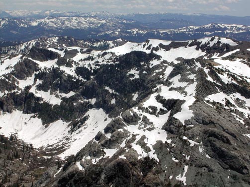
up the peak. I regard Round Top as an easy two hour climb in the
summer, and I had thought to climb another peak this fine day.
I kept a good eye on him, fearing some bad slip. It isn't worth
an injury and rescue to have people explore, enjoy, and protect.
I had given him the benefit of the doubt, but I recalled doing
the same to others. They jeopardized themselves and the rest of
the group. Watch out for some quite false entreaties to
skills and ability!
We climbed on snow more directly to the
peak's northwest ridge. My partner chose some less steep snow
slopes for himself. We worked up to the northwest ridge, which
was partly bare. We caught the scree trail, and worked up to the
steeper, rocky part. He was doing O.K. I surmised to leave him
at a spot, and bag the peak myself. But, he seemed fine, all smiles
at the beautiful views. The snow was in good condition, perfect
for step kicking and standing glissades. He stated to have never
ever done a self-arrest, but the footsteps were holding, and there
was sufficiently safe run-out under the snow slopes we climbed,
or were traversing. But, as I warned, you can slash yourself,
even fatally, with your own ice axe. This is a extremely dangerous
instrument, in the hands of novices. I take none of this lightly.
Keeping a good eye on his rock technique,
I ascended the final, rocky, class 2 part to the hikers' summit.
Wow! We were on top of the point where many people will stop.
I regard the true highpoint on the last summit mass to the east.
I led my companion carefully, not wanting to rush or disconcert
him. I know the best way, being my 16X, so we carefully scrambled
to the last gully before climbing up to the true highpoint. Some
delicate moves for a beginner were done, and then I directed him
to downclimb, crouching, with a low center of gravity. A short
loose, rocky slope needed to be descended. This is class 2, and
the "exposure" here turns many a hiker back. It must
be at least 1,500 feet down to the bottom. Early in the season,
this chute may be filled with hard or frozen snow. If you slip
and can't stop yourself, you are definitely toast!
This last chute was clear and free of snow,
for us, however. I spotted some moves for him. He had to downclimb
facing inward. Then we had downclimbed into the chute, and now
it was an easy scramble over to the summit mass. Ledges, and an
easy class 3 gully, with great holds and plenty of steps led us
up. It was in the bag!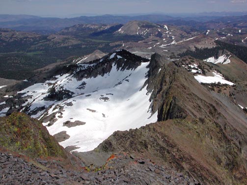
I topped out at 1:54 p.m., and he followed
shortly. I immediately went about snapping the spectacular views.
I urged him to take off his pack and get comfortable. We would
be up here for some time.
I had several projects with my digital
camera. We took out the several books out of the ammo can register,
and laid them out with the first page up. I snapped photos to
show the start date for each book. Then we turned the books to
the last page, and I shot more photos of each book. This gives
us a digital record of the dates of the presumed first and last
sign-ins for each book. Yes, I do know people don't always sign
in order, but there were hundreds of pages we'd have to look through.
I also left a new, large notebook, which might last a couple years.
The next project was to use my clear plastic
canteen to employ the water level as a sight. This would line
up over or under the peak in the distance, captured in the same
photo. Some hikers say the first, west summit you'll come to is
the higher one. l have always disputed that, since the maps indicate
the eastern bump is the one with the peak name affixed to it,
on the maps. The register has been there for the 31 years
I have been climbing this peak, and I think it looks higher.
My photos seemed to show, on review, that
it might be a toss-up. Depending on the particular photo, the
water line can show that the two peaks could be in any order as
to height. Mostly, they showed I was right, but it is too close
for a conservative measurer to tell. Starting down at 2:57 p.m.,
I did the same surveying with my water bottle on the hikers' peak
back toward the climbers' peak. My call, by the photos, too, is
that the climbers' peak is the higher one.
I kept us together, and urged my companion
to hike down carefully. I didn't wish an accident. It is probably
very unwise to recruit a peak climbing partner from the Net. I
may not do this again.
Gratefully he made it down, and then we
were back on scree. I chose a direct route down on some snowfields
for my standing glissades. The snow was like silk! My companion
chose to hike down on adjacent dirt slopes, and couldn't move
very fast, on even gently angled snow.
Thankfully, we made it back to Winnemucca
Lake and the good trail, and now it was only a matter of time
to get back to the cars. I sped ahead to let the ranger volunteers
at the visitor center cabin know we had been successful, and were
safely back. I didn't want anyone to call up a search and rescue!
To the cabin at 5:08 p.m., eight minutes
after closing, I began to write a note. You do not tell staff
that you'll check back with them, after your climb/hike, and then
fail to notify them! The door swung open as I was going to slip
my note under the door. The ranger volunteers were still there,
inside. What a relief!
All clear with the USFS, we packed our
gear into my car and left for home. I had thought to go to another
peak for a late day climb, but we had had enough.
Our climbing stats were maybe 8 miles with
1,900' gain round trip. I shot some 186 images, but with no movies.
So our total hiking, round trip time was some six hours and thirty-eight
minutes. We saw other hikers climbing the peak, but they all stopped
at the hikers' summit. I would have loved to help them up the
true summit, but I was taking up enough responsibility with my
ill trained companion. And two downhill skiers had left tracks
on the peak slopes.
I don't like being told one thing to have
another thing be the fact. The local hikers don't regard telling
the truth, about their skill level and experience, of any concern
or importance. Wild and improbable claims are the norm. Anything
to get on the trip, a ride, and start up a trail! Most will then
see the peak we'll climb, and that's too much for the novice.
Votes to go for beer and pizza, by some. Or to Stateline or Reno,
even! I am still learning about people.
BACK TO PETE'S THOUSAND
PEAKS HOME PAGE