HIGHWAY CA 88 FALL COLORS AND FREEL PEAK (10,881') 11X October 25, 2003
Being that the end of the Sierra hiking season was nearing, I sought to make a short trip to enjoy the remnants of fall colors, and make this easy climb to the top of this highest of peaks on the Lake Tahoe Rim.
My luck was pretty good, lately. I had
won from each of my latest, past trips to Reno, Vegas, and the
local California casino. Albeit small amounts, I left with more
than I came in with. I even nearly doubled my money with my latest
Lotto ticket!
With my car, whose repair was going smoothly, I can leave town in the morning, and that evening, be sipping a latte watching the sunset over the Columbia River Gorge. Or, I could leave early, and wake up the next day with miles and miles of Utah red rock all around me. More modestly, I can be munching a fish taco to watch the ocean sunset from San Diego, or hiking about downtown L.A., both with not even leaving early. This winter, if I should get a sharing travel companion, I can take off early and be standing in line, the next morning, for the first ski lift to open, all the way to Western Colorado. But, I assume there'll be no takers. Without any congenial partner for any of this, I figure on mainly walking about town, and occupying myself with my computer.
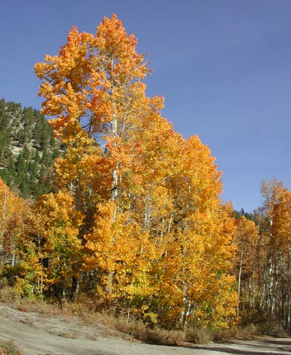
Up at a good hour this Saturday morning, I drove east on U.S. 50 to take the Mormon-Emigrant Road over to scenic Highway CA 88. I am apprised of some colors lingering, with the latest "peak" I have heard of. I had to see this for myself.
The aspens near Silver Lake were all turned. Various groves shone with yellows in the morning sun. Caples Lake was good, although some, entire stands were now bare of leaves. My favorite stops on the east side of Carson Pass were O.K., but past "peak." Some other photographers were snapping away.
I headed north along CA 89, and came to the dirt side road, 051, for my solo peak ascent today. I enjoyed more good colors driving slowly up this rough road.
I started my hike at 11:07 a.m., and noted the new details. Most all of the signs were different from my past peaks guide details. I came to Armstrong Pass, and headed right on the Tahoe Rim Trail.
Good, colorful, groves were seen to the west below me. I was having a good time with my camera. The winds had cleared away the haze, and I expected a great vista from the top. Seeing no one till the high point of the trail, I spoke briefly with a trail runner who had come from Kingsbury Grade. It took me two hours to get here.
Taking the use trail upwards to the peak, I stayed on the right (west) side of the small ridge. Spotting two figures on top, I followed the good sandy use trail, then came to a sign, stating, "please do not enter." The concern is that hikers may be damaging the endangered plant, Tahoe Draba, that grows up here. The sign advised staying off ridges, and the north and east facing slopes.
The sandy use trail climbs up in a large, sandy bowl, and with care, one need not step on any plant. They are easy to avoid. I came to the top at about 2 p.m., less than 3 hours after starting. I did well.
Surfing the Net, beforehand, looking for accounts about doing Freel Peak, I had come upon a site with a USFS document addressing the construction of a trail to the top of Freel Peak. I'd be mildly opposed, due to the cost, and the crowds that an official trail would bring up here. More damage might be done with just one thoughtless person picking the flowers. Right now, most peak hikers will follow the use trail. But, whatever the government decides is fine with me.
I shot many photos from the summit, and did a panorama sequence of the Lake which came out pretty good. I tried for a good picture of myself, as well.
I looked through the ammo box register, with three books that I had placed, filled and still up here. Loose pages and plastic baggies filled up the container, with packaged food left by someone. I prepared and placed another book, which should last another year. A larger container is needed.
Another hiker came up with two dogs. I
chatted a bit, and then saw other hikers far over on Jobs Sister
(10,823'), the next peak to the east.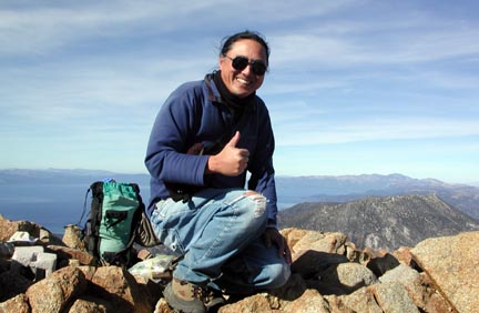
We two hikers agreed to hike back down the south side of the peak, together, a more direct way back to our cars. A fine sand and scree route heads down, allowing for plunging steps, and thus a quick descent. The trick to this is to stay left, and follow the sandy route all the way down to Horse Meadows. To the right, one will encounter rocky dirt and brush, making for a more tedious descent. We got into a boggy meadow near the bottom, but I didn't get my feet too wet.
Back to a dirt road in one hour from the top, we talked a bit as I navigated us back to the main dirt road. I went on to my own car, and arrived there at 4:26 p.m. Informed of the easy way to climb this peak, the other hiker checked it out. The TRT trail route isn't well known, and doesn't appear except on the latest maps. I am always happy to help.
I drove slowly back down this rough dirt road. Some low clearance cars might not do it safely. The sun was setting, and the light was getting lower. Along CA 88, I snapped a few more photos, then enjoyed the evening views while motoring down on the west side of the Sierra.
The dry weather pattern is said to be holding, so maybe another Sierra peak will be my choice, for later this fall.
I had hiked some 5.5 miles with 2,400' gain, total. I shot some 230 digital images. I spent only some $5 for food and drink. But, I used maybe 3/5 of a tank of fuel.
The structure once standing near the top has been removed. Maybe they are attempting to restore the summit area back to nature. I like this!
It was breezy on top, but I wore only a T and jeans hiking up. I put on a light pullover below the summit, then later, on top, a parka, gloves, and warm hat. Some record highs are predicted for the area, so these are fine conditions to enjoy the high peaks, at this late time of the year. I recalled my first climb of Freel Peak, with up to three feet of fresh snow, all hiked from CA 89 via Road 051. This was in early November, on a long past, scheduled, Sierra Club trip. There is a big difference between year to year!
BACK TO PETE'S THOUSAND PEAKS HOME PAGE